Learning lessons from disasters
While humans, through the emission of greenhouse gases, bear some measure of responsibility for sea-level rise, ocean warming and acidification, the coasts are also exposed to a number of natural threats as well. These include earthquakes, landslides, tsunamis and volcanic eruptions, as well as natural climate phenomena, particularly the Pacific climate anomaly known as El Niño. Although humans have no direct influence on the occurrence of such events, a variety of technological solutions have been developed to protect coastal communities as far as possible and to minimize damage to property. Many lessons have been learned from past disasters, as evidenced by modern disaster preparedness schemes for tsunamis.
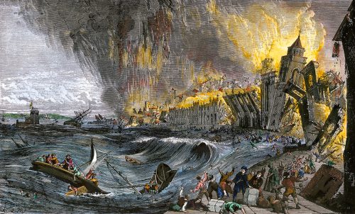
- 3.19 > It was one of the most devastating natural disasters in the history of Europe. When the earth shook on 1 November 1755 in Lisbon, tens of thousands of people died beneath the rubble of buildings, in the fire storm, and in the floods of a tsunami.
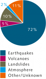
- Tsunamis are especially large waves that can travel for thousands of kilometres across the sea. As they approach a coast they are slowed down by the shallow water, which causes them to rise up many metres in height. Up to 70 per cent of all tsunamis are triggered by earthquakes, mostly in the sea. Other causes include volcanic eruptions or landslides, in which large amounts of sand, rocks or sediments surge downslope like an avalanche. The more material that is set in motion or the faster it moves, the more energy the resulting tsunami possesses.
Catastrophes out of the blue
For a long time people in coastal areas were simply at the mercy of tsunamis because they came with no warning at all. A tsunami on 1 November 1755 caught the people of Lisbon, Portugal’s capital city, completely unprepared. On that day, about 200 kilometres to the west of the Strait of Gibraltar, a powerful submarine earthquake occurred that was so violent it destroyed most of the city. To add to the devastation, it triggered an enormous tsunami that flooded large areas of the city around 40 minutes after the earthquake. According to various estimates, between 30,000 and 100,000 people lost their lives due to the earthquake and tsunami in the Portuguese capital alone. Other cities and villages on the Portuguese and the Moroccan coasts were also devastated. Even on the other side of the Atlantic, in the Caribbean Islands, the tsunami caused damage to harbour structures and boats.
Especially high-risk regions
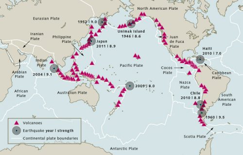
Regions in the Pacific are especially threatened by tsunamis because of the tectonic plate boundaries that run parallel to the coasts and are often characterized by heavy seismic and volcanic activity. This is why the term “Ring of Fire” is used to describe these regions. In the western Pacific they include the coasts of the Philippines, Indonesia, Japan and Russia, while in the east large segments of the coasts of North and South America make up the ring. Many sites within the Ring of Fire have repeatedly experienced strong earthquakes throughout history that have also triggered large tsunamis.
Japan also lies on the Ring of Fire. Because multiple plate boundaries meet here, the country has frequently been shaken by strong earthquakes. Likewise, numerous giant waves have occurred in this area throughout the past, and the phenomenon received its name there long ago. The term “tsunami” is of Japanese origin and derives from the words “tsu” (harbour) and “nami” (wave). The term tells us that the waves are especially destructive to harbour cities.
- 3.20 > The Ring of Fire circling the Pacific. The coastlines run parallel to plate boundaries, where many earthquakes originate. These may often be followed by tsunamis.
- 3.21 > Tsunamis can have different causes, but earthquakes are the most important triggers.
Development of the Japanese tsunami warning system
It was a long time before people began to understand how to interpret the initial warning signs. On 15 June 1896, a tsunami with a wave height of 38 metres hit the northeast coast of Japan. Around 20,000 people died. It was unusual that the earthquake preceding it was only weakly felt on the Japanese coast, but still produced such a powerful tsunami. This led to a debate in Japan over the origin of this enormous wave. Some specialists attributed the tsunami to submarine landslides. Although the causes remained unclear, the ensuing discussion led to an increased awareness of tsunamis in Japan.
Among the citizens of Japan, the perception generally spread that earthquakes were an important warning sign for possible tsunamis. The general rule was accepted that “When the ground shakes it’s time to evacuate”. In 1933 a tsunami hit the northeast coast of Japan, again following closely after an earthquake. This time the population was better prepared and many saved themselves by escaping to higher ground. Still, around 3000 people lost their lives.
In 1941 Japan became the first country in the world to implement a tsunami warning system – at the meteorological station at Sendai, a large city on the east coast. A seismometer was permanently installed there that could be used to estimate the strength and approximate distance of earthquakes. From then on tsunami warnings were announced on the radio, and police stations were informed in the affected regions. As a rule, it took 20 minutes from assessment of the earthquake data until a tsunami warning was given.
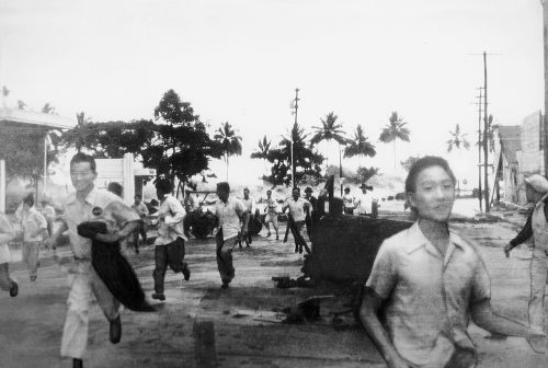
- 3.23 > A tsunami hit the coast of Hawaii on 1 April 1946. The triggering event was an earthquake that occurred 4000 kilometres away near the Aleutian Islands. It took 4.5 hours for the tsunami to travel from the site of its origin to Hawaii, where it took the lives of 159 people.
- In the following years more seismometers were installed in various other regions and finally, in 1952,
the Japan Meteorological Agency (JMA) implemented a nation-wide tsunami warning system. By 1999, increasingly technologically advanced seismometers had been installed that constantly improved the speed and quality of determinations of the intensity and location of earthquakes. Tsunami warnings could ultimately be announced within 3 minutes after an earthquake. But in spite of the use of mathematical simulation models, it was not possible from the earthquake data alone to reliably determine the size of the tsunami to be expected. After the tragedy of
11 March 2011, the tsunami warning system in Japan was finally significantly improved. On this day, off the coast of the northeast Japanese region of To–hoku, a strong submarine earthquake occurred. Around 16,000 people died in the quake and the great wave it produced.
As a consequence, sensors were installed on the sea floor off the Japanese coast that could recognize a tsunami wave passing overhead based on discernable changes in pressure. Thanks to the deployment of these additional sensors, the ability to determine the path of a tsunami and estimate the size of the wave expected to hit land has been greatly improved.
Development of the tsunami warning system in the USA
Not only in Japan but also in the USA, efforts to develop a warning system began relatively early. In the Aleutian Islands, which extend from the coast of Alaska far out into the Pacific, a strong earthquake occurred in 1946 and triggered a large tsunami. The wave was so enormous that it completely destroyed a steel-reinforced concrete lighthouse that stood atop a 12-metre-high cliff on the Aleutian Island of Unimak.
4.5 hours later the tsunami reached the Hawaiian Island group 4000 kilometres away. It hit the inhabitants with no advance warning, because the earthquake was not felt here at all. The waves were up to 16 metres high and in some locations the water penetrated a thousand metres inland. 159 people died. The tsunami was also felt on the northwest coast of the USA. The waves here were only about 2 metres high, but there was still some damage to boats in a number of harbours.
After this experience, US officials established a tsunami warning centre in 1949 near Honolulu, Hawaii. Similar to the system in Japan, their method was based on identifying earthquakes and calculating the travel time of a potential tsunami. If a partner country reported an earthquake, the centre would calculate the travel time of a possible tsunami wave to its arrival on the coast of the USA.
-
Earthquake intensity The intensity of an earthquake is determined on the basis of a moment magnitude scale. The scale ends at a value of 10.6. This maximum intensity is reached when the Earth’s crust breaks completely apart in the area of the earthquake. Theoretically it is not possible for an earthquake to release more energy than this. The structure of the scale is logarithmic. This means that the strength of the earthquake increases exponentially with the scale value. One point on the scale is equivalent to an increase in energy of about 30 times. For the purpose of visualization, the seismic energy of an earthquake can be compared to the explosive power of TNT. The energy of an earthquake with a magnitude of 5 is equal to about 475 tonnes of TNT; that of a magnitude 6 earthquake is equal to about 15,000 tonnes of TNT.
International cooperation emerges
For a long time Japan only generated warnings for its own coast, while the system in the United States rapidly developed into an international warning centre for the entire Pacific realm. The impetus for this international cooperation was an earthquake that struck near the large city of Valdiva in Chile on 22 May 1960. The Earth’s crust ruptured on land in Chile from north to south over a length of 1000 kilometres. This included the jarring movement by 20 metres toward the west of a 200-kilometre-wide block situated between the continental margin and the Andes. This triggered an enormous tsunami wave that caused immense damage nearby, particularly on the coast of Chile, and then spread westward across the entire Pacific.
Hawaii experienced 10-metre waves, while the more distant east coast of Japan was subjected to 5-metre waves. Because other countries in the Pacific and island nations in particular were impacted, UNESCO (United Nations Educational, Scientific and Cultural Organization), beginning in 1960, strongly pushed for the implementation of a Pacific-wide warning system. The Intergovernmental Oceanographic Commission (IOC), established by UNESCO after the earthquake in Chile, was responsible for the international cooperation. The IOC member states decided to integrate the system with the existing warning centre in Hawaii. It began operations in 1965 as the Pacific Tsunami Warning Center (PTWC). The PTWC still coordinates tsunami warning and prediction for the entire Pacific realm on behalf of the USA’s National Oceanic and Atmospheric Administration (NOAA).
As in Japan, the accuracy of tsunami prediction was limited in the beginning. The warning system essentially consisted of member states informing each other by telephone whenever an earthquake was recorded. Aided by the seismographic information and travel-time maps, calculations could then be made to determine whether and when a possible tsunami could hit land. This information was augmented by water-level measurements in various coastal areas. But predictions still remained uncertain.
75 per cent of all tsunami warnings were false alarms, which often led to expensive evacuation measures. In 1986 an alarm led to the evacuation of Waikiki, a district of Honolulu. Many public buildings in this part of the city had to be vacated. Although waves arrived at the beach at the expected time, they were only slightly larger than the normal surf. Officials in Hawaii estimate that the interruption of normal business as a result of the false alarm caused losses equivalent to 41 million US dollars. This was followed by considerable criticism of the efforts of the PTWC tsunami warning centre.
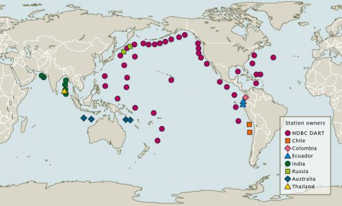
- 3.25 > Since the 1980s a tsunami warning system of buoys has been installed around the Pacific that receive signals from pressure sensors on the sea floor. These sensors detect tsunami waves.
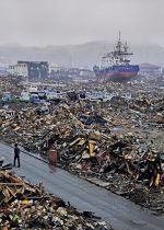 3.24 > The earthquake off the east coast of Japan on 11 March 2011 lasted around 5 minutes. It triggered a tsunami that devastated broad areas of northeast Japan and also breached the seawall of the Fukushima I nuclear power plant.
- In 1987, therefore, NOAA decided to install a completely new warning system that delivers tsunami data in real time. This consisted of pressure sensors on the sea floor that send data to buoys at the surface through an acoustic signal. The buoys then transmit the data via a satellite connection to the PTWC. The advantage of this is that the system directly measures the strength of the tsunami wave, providing a reliable indication of its magnitude and behaviour at landfall. It therefore complements very well the classic seismographic earthquake measurements.
This buoy system is known in the USA as DART (Deep-ocean Assessment and Reporting of Tsunamis). It is operated by the National Data Buoy Center (NDBC) of NOAA and continues to be upgraded even today. Australia, Chile, Colombia, Ecuador, India, Russia and Thailand are now also using these kinds of buoys. Japan developed its own buoy system, but is gradually giving this up in favour of pressure sensors connected by cables. In the Pacific and adjacent marine regions today, more than 50 buoys have been installed that can be used by the PTWC.
A tsunami alters global awareness
The cooperation among many countries around the world today in the field of tsunami warning is, to a large extent, a consequence of the catastrophic tsunami that occurred on the morning of 26 December 2004 in the Indian Ocean. At 7:58 a.m. there was a submarine earthquake with a magnitude of 9.1. It was centred about 85 kilometres off the northwest coast of the Indonesian island of Sumatra on the Sunda Arc, and triggered several seismic shocks and severe tsunamis that struck the coasts of 16 countries around the Indian Ocean.
The Sunda Arc is a 6000-kilometre-long subduction zone that runs along the coast of Sumatra, extending from Myanmar in the north, through and beyond the Indonesian Island of Java in the south. At the Sunda Arc the Indo-Australian Plate is thrust beneath the Sunda and Burma Plates, which is why this region frequently experiences earthquakes and strong volcanic activity. The coast of the island of Sumatra, the island of Sri Lanka located to the west of the epicentre, and the Indian coast were especially hard-hit because of their proximity to the Sunda Arc. The northern coastal districts of the large Indonesian city of Banda Aceh on Sumatra were completely destroyed. In all, 235,000 people lost their lives, 170,000 in Indonesia alone. 1.7 million people lost their houses and dwellings.
- It was disastrous that, in contrast to the region covered by the PTWC, hardly any of the affected countries had established tsunami catastrophe protection programmes. Because the victims also included many tourists, the event had an immediate and huge international impact. Measured by the number of victims, the tsunami was the greatest natural disaster ever for Sweden; for Germany it was the largest since 1945. More Germans died in this catastrophe than in the flooding of Hamburg in 1962. A total of 13.5 billion US dollars were raised worldwide to assist with reconstruction in the disaster area.
The tsunami of 2004 drastically altered public perception. After this momentous event the world immediately developed a heightened awareness of this natural hazard. At their annual meeting in June 2005, member states of the IOC called for the establishment of new international warning networks for the Indian Ocean based on the model of the PTWC. As a further consequence, appropriate warning centres were established under the auspices of the IOC:- The Caribbean and Adjacent Regions Early Warning System (CARIBE EWS),
- The Indian Ocean Tsunami Warning System (IOTWS),
- The North-Eastern Atlantic, the Mediterranean and Connected Seas Tsunami Warning and Mitigation System (NEAMTWS).
The Indonesian warning system – constructed from scratch
After the tsunami of 2004, there were intense international efforts to install a reliable warning system in the Indian Ocean. In especially hard-hit Indonesia, particularly with German assistance, a dense network of survey stations was built: the Indonesian Tsunami Early Warning System (InaTEWS), which is part of the IOTWS system for the entire Indian Ocean.
Unexpected problems arose right away, at the beginning of the installation. Like in the Pacific, plans for the InaTEWS also included incorporation of some DART buoys. These, however, were repeatedly damaged by vandalism or carelessness; batteries were removed or the technical mechanisms destroyed because fishermen frequently used the DART buoys for mooring. It was therefore decided that a combination of other sensors would be installed exclusively on land in Indonesia. This had the additional advantage of avoiding the expensive maintenance costs of equipment at sea.
- 3.26 > The devastated coastal strip of Banda Aceh (left, 2005) was rebuilt (right). One of the towers of the new warning system, outfitted with a siren, can be seen in the right-hand picture.
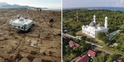
- The system presently includes a network of 160 broadband seismometers that were installed along the coast and precisely record the waves of an earthquake in real time. Additionally, around 50 survey stations record the water elevation to recognize anomalous changes in sea level. About 30 GPS stations were also established on land. This concept is based on the fact that continental plates shift during an earthquake and the GPS sensors can detect this motion. The reliability of prediction is increased significantly by the combination of these three types of sensors, because the information from a single sensor type alone is not sufficient to conclude the formation of a tsunami.
Mathematical models have been developed that can statistically evaluate the sensor data within a few seconds and, with the help of simulations, determine whether a tsunami will be triggered and its impact on land. The sensor data are processed in detail by two models. One models the formation of the tsunami while the other integrates the phases of propagation through the sea and flooding on land. Within a matter of seconds the sensor data are compared with a multitude of previously calculated possible tsunami scenarios. This means that in the case of a catastrophe the time-consuming calculations of probable pathways no longer need to be made. Only now, with this comparison to multiple scenarios, is it possible to make quick and quite reliable predictions accompanied by assessments of statistical uncertainty. All things considered, with the InaTEWS system an alarm can now be sent out within five minutes for the entire Sunda Arc region.
Preparing for the next waves
Not only must warning systems be constantly improved, increased investments in protection measures also have to be made in regions at risk from tsunamis. The IOC is responsible for coordinating this tsunami protection worldwide. It relies largely on educational efforts to teach people to recognize the warning signs of a tsunami and to practice the correct behaviour in the event of a disaster. In many countries, therefore, emergency drills are regularly carried out under the direction of the IOC during which both the warning system is tested and evacuation procedures are taught.
Furthermore, the IOC sponsors the construction of tsunami protection systems. In recent years these have mostly been installed in Indonesia. They include warning sirens, flood-resistant structures built on sturdy stilts that people can escape to, or escape routes that lead quickly to the hills or higher areas of the cities that people can run to. Preliminary evacuation drills have shown, however, that congestion quickly builds up, preventing large numbers of people from making a rapid escape to safe areas. In view of this, the IOC recommends for Indonesia the construction of more flood-resistant buildings in areas directly threatened by tsunamis.
- 3.27 > The tsunami warning system for the Indian Ocean, developed with significant input from German researchers, is composed of measurement stations located exclusively on land. It includes 30 GPS stations, 160 broadband seismometers and 50 gauging stations to record the water level.

- The IOC also endeavours to promote a general awareness of the danger. The tsunami of 2004 clearly showed that the majority of people in the affected countries were completely unaware of the existence of the tsunami phenomenon before the catastrophe occurred. Only on a few islands in the Indian Ocean has the danger of tsunamis been understood and remembered over many decades.
Keeping the memory alive
The island of Simeulue, located 150 kilometres west of Sumatra, is an example. Although the island was struck hard by the tsunami only seven people died. The rest of the inhabitants, still a significant number of around 70,000 people, were able to save themselves by escaping to higher elevations. This was only possible because the people had kept alive the memory of a tsunami that occurred in 1907. The elders referred to this event as “Smong” in their language, and in their traditional stories described very accurately the three phases of tsunami development: the vibrations of an earthquake, retreat of the water, and the approach of the flood wave. The inhabitants of the island were therefore prepared when the tsunami came. They reacted appropriately and most survived.
Threat of tsunamis in the Mediterranean
Similar to the situation off Indonesia, continental plate margins are also located throughout the Mediterranean Sea, and are likewise the sites of frequent earthquakes and active volcanism. Furthermore, the Mediterranean Sea is comparatively small so that, like in the Sunda Arc, a tsunami can reach land within just a few minutes. Second only to the Pacific region, the Mediterranean Sea is considered to be the area most threatened by tsunamis worldwide. The consequences of a tsunami there can be especially devastating because the Mediterranean is a very popular vacation region where hundreds of thousands of visitors go to enjoy the beaches and bathing.
Italy is a good example of a tectonically very active region. At a subduction zone there an extension of the African Plate, the Apulian spur, thrusts beneath the Eurasian Plate to the north. This subduction zone runs lengthwise from north to south through Italy, curves westward in the south and continues further through Algeria and Tunisia. Because of this geological configuration, Italy is repeatedly subjected to large quakes. The intense earthquake in Messina on 28 December 1908 is well known. It almost completely destroyed this Sicilian city as well as the Calabrian cities of Reggio Calabria and Palmi. It also triggered a tsunami that caused further damage. Estimates of the total number of deaths in the region range from 72,000 to 110,000 people.
The difficulty in forecasting tsunamis in the Mediterranean Sea
Although the North-Eastern Atlantic, the Mediterranean and Connected Seas Tsunami Warning and Mitigation System (NEAMTWS) has been in operation since 2005, it is still not possible today to accurately determine how great the risk actually is for tsunamis in the various marine areas of the Mediterranean Sea. In recent years, as part of a European cooperative project, investigations using mathematical models were carried out to determine how tsunamis interact with the sea floor in the Mediterranean and how the complex shapes of the Mediterranean coastlines, with the many offshore islands, deep-cutting embayments and differences in water depth, affect their propagation. The results are now being evaluated, and should help to identify areas that are at especially high risk, in order to install protective facilities such as escape routes or seawalls in those areas. There has been some criticism that cooperation among countries bordering on the Mediterranean is not adequate, even though the NEAMTWS is in place. The countries do inform each other in the event of danger, and they carry out joint emergency drills and communication tests. But Portugal, France, Greece, Turkey and Italy each develop their own scenarios and models.
At the UNESCO level, efforts are now being made to promote a better exchange of information among the countries in the future, because when multiple models are compared with one another the quality of prediction is significantly improved. If the conclusions are all similar, then the confidence that the tsunami will behave precisely in that manner is greater. If the conclusions are conflicting, however, or significantly different from one another, then the uncertainty is greater and it would be prudent to collect additional information.
Earthquakes – a dual threat for the coasts
Not only do earthquakes trigger tsunamis on the coasts, they themselves can cause extensive destruction. This was illustrated by the earthquake that occurred in 2003 a few kilometres off the coast of Algeria. Of the more than 2000 people who died, most lost their lives in collapsed buildings. The earthquake gave rise to a weak tsunami that travelled northward. Just an hour later it reached the Balearic Islands, where it damaged boats and cars but no people were injured. The problem is that the buildings in Algeria were not designed to withstand earthquakes and thus collapsed. There are many other coastal areas in the Mediterranean that are at greater risk from earthquakes because the buildings are not built to withstand them.
The coastal city of Istanbul is of particular interest in geoscience research. The city lies on the western extension of a continental fracture zone, the North Anatolia Fault, and is considered to be at very high risk. Based on seismographic measurements on the fault, an earthquake with a potential magnitude of up to 7.5 has been expected for quite some time. Such an earthquake would probably have catastrophic consequences because many buildings in the Istanbul metropolitan area were not constructed to withstand an earthquake. According to a study by the United Nations up to 50,000 deaths could be expected. In Japan it has been shown that earthquake-proof buildings can be constructed. There, even tall office buildings have been able to survive quakes with intensities greater than 8. The buildings are designed to be relatively elastic so that they can absorb the shock.
Landslides – spatially limited and unpredictable
Danger to the coasts also exists in the form of landslides. These originate on the flanks of slopes when large amounts of debris or sediment break loose and plunge into deep water. Landslides can occur on land or on underwater slopes where the material can be transported to great depths. This can result in various hazards for the populations. For one, in the landslides on land people can be buried and residential areas can be destroyed. For another, when it plunges into the sea, the impulse transferred to the water by the slumping of the material could produce a tsunami.
In contrast to earthquakes, which can be precisely recorded and analysed today by modern seismometers, many landslides occur completely unnoticed because they are relatively limited in areal extent. While earthquakes originate along tectonic faults of up to 1000 kilometres in length and are observable on a very large scale, slope collapse, as a rule, usually only occurs at a scale of up to a few dozen kilometres. They therefore produce only comparatively minor tremors.
Although landslides have been intensively researched for a number of years, there are still many unanswered questions. When or where they may occur is not predictable, so direct observations or measurements are almost impossible. Even though it cannot be stated with certainty why a slope has slumped at a specific time, we do have a fundamental understanding of the factors that can lead to landslides. These include:- Earthquakes that can mobilize the material;
- Gas seeps on the sea floor that destabilize the material;
- Storms producing powerful wave action that break material loose;
- Undercutting of steep cliffs by erosion, for instance by currents over long periods of time;
- Changes in the pore pressure in the sediments;
- Volcanic activity that causes entire flanks of volcanic islands to collapse and fall into the sea.
- Worldwide, research on landslides has intensified since the turn of the century. One reason for this is the tsunami that occurred on 17 July 1998 in northern Papua New Guinea. On that day there was an earthquake on the coast followed 20 minutes later by the flood wave. It destroyed three coastal villages and killed 2200 people. Soon afterward, because of the severity of the tsunami, the coastal region was intensively investigated. The studies revealed that on the slope off the coast, in a 4-kilometre-wide area, sediments had slumped downward by about 1000 metres. This sudden collapse probably led to a vertical motion of the water column. The waves triggered by the motion were strong enough to cause destruction along a 30-kilometre-wide segment of the coast.
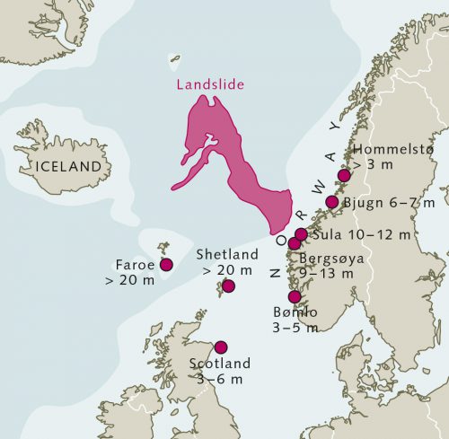
- 3.28 > 8200 years ago, off the west Norwegian coast, one of the largest landslides known today occurred. At that time a large piece of the Norwegian shelf edge slumped off and plunged several hundred kilometres out into the Atlantic.
- As a consequence of this event, debate intensified regarding the frequency of such landslides and the kinds of hazards they pose. Many coastal regions were investigated using research ships and surveyed with geophysical instruments – including the multibeam echo sounder, which scans the bottom with acoustic waves. The acoustic waves are transmitted from the ship in a fan shape so that a wide strip of the sea floor is recorded. The time required by the acoustic waves reflected from the sea floor to return and be recorded by the ship varies depending on the depth of the sea floor. From the differences in travel time, an elevation profile of the sea floor is calculated on which the evidence of landslides can be clearly seen because, like an avalanche, they leave deep scars in the sediment. The Mediterranean Sea, for example, which is characterized by steep slopes in many locations, has now been almost completely mapped. The depth profiles have been stored in large databases. These document numerous past landslides whose traces have been discovered with the help of the modern instruments.
An area of the Norwegian Sea in the North Atlantic has also been thoroughly studied. There, on the continental slope off Norway on the southern Vøring Plateau – called “Storegga” (the great edge) in Norwegian – one of the largest slumps known today, called the Storegga Slide, occurred 8200 years ago. At that time a 5600 cubic kilometre block of the Norwegian shelf edge slumped off. This impulse triggered a tsunami in the North Sea that attained a height of 20 metres at landfall on the coast of the Shetland Islands. Researchers were able to conclude this based on deposits at the corresponding elevation.
Repeated massive collapses
It is now known that there are some coasts where, over the course of time, landslides have occurred repeatedly. Off the coast of the West African country of Mauritania, for example, there are areas where multiple old and young slides overlap. This region is known as the Mauritania Slide Complex. Through coring and analysis of the various sub-bottom layers, it has been discovered that the oldest slide deposits are around 20,000 years old, whereby the individual events apparently occurred at intervals of a few thousand years. Compared to the billions of years of Earth history, that is a short period of time. In the Gulf of Mexico off the coast of the USA, in the Ursa Basin, a flank was discovered on which slides have occurred in the past at a frequency of about one every 5000 years. Further research will be necessary, however, in order to estimate the global average frequency of landslide occurrences.
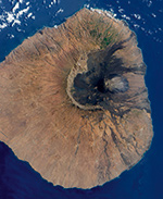
Efforts have also been underway for a number of years to resolve the possible wave heights of tsunamis triggered in this manner, and their destructive potential. Useful evidence toward this goal is provided by deposits on coasts that have been struck by tsunamis in the past. Noteworthy in this respect is the example of the volcanic Cape Verde island of Fogo, which rises out of the water with a diameter of around 30 kilometres. Based on deposits on the sea floor, it has been discovered that around one-third of this volcanic cone slumped into the sea about 73,000 years ago. The material that was mobilized had a volume of about 500 cubic kilometres, which is equivalent to a block five kilometres high with an area equal to that of the german city of Osnabrück. This mass motion produced a powerful impulse that forced the water at the shore of the neighbouring island of Santiago, 40 kilometres away, to a height of 270 metres. Tsunamis like this, with wave heights of greater than 100 metres, are referred to as megatsunamis.
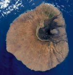 3.29 > Landslides can trigger megatsunamis with heights exceeding 100 metres. When the flank of the Cape Verde island of Fogo plunged into the sea 73,000 years ago, a tsunami wave was formed that heaved water at the coast of the neighbouring island of Santiago to a height of 270 metres.
Understanding the distance effect
Researchers are currently investigating how far waves initiated by landslides can travel. Because they are relatively small events compared to submarine earthquake waves, the impacts of landslides are more local in nature. But waves triggered by them can reach very great heights. It is unknown, for example, whether the landslide on Fogo caused any damage on the coasts of Africa or America because it is difficult to find any traces there of a tsunami that happened 73,000 years ago. It is generally assumed, however, that tsunamis triggered by landslides do not have the kind of long-distance destructive effect that the earthquake of 2004 had. But even when landslides do not trigger a tsunami they can still be destructive. There have already been many cases where submarine landslides have severed telecommunication cables, which then led to expensive repair work. There has also been some discussion of the potential dangers to oil pipelines and drilling platforms that have been installed on slopes.
There are also known cases of landslides being triggered by human activity, such as the slide at Nice on 16 October 1979. About two kilometres off the coast of Nice the sea floor falls steeply parallel to the shoreline. In 1979 a harbour jetty was built outward like a finger pointing into the sea. The construction activity and especially the immense weight of the breakwater structure itself eventually caused the slope to cave and slump downward, taking the new harbour with it. Shortly afterward a tsunami reached the area around Nice with a height of three metres, but it subsided again relatively quickly. Still, several people died.
El Niño – climate fluctuation with major consequences
Another natural phenomenon that can impact coastal habitats is the El Niño climate event, which occurs irregularly every three to ten years in the tropical Pacific. It arises when the atmospheric pressure relationship between the western Pacific and the central Pacific is reversed, leading to large-scale directional changes in the prevailing winds and surface-ocean currents. As a result, it greatly changes the spatial distribution and intensity of precipitation over land and thus, to a similar degree, the living conditions for coastal human populations and marine organisms. There are natural climate fluctuations in other marine regions of the Earth that occur with a certain rhythm. But El Niño is considered to be the largest in the world and the one with the most severe consequences.
The phenomenon is especially dreaded by the fishermen on the coasts of Chile, Ecuador and Peru because El Niño can lead to a decrease in the volume of their catch. Because of the upwelling of nutrient-rich deep water, the Pacific coast of South America is normally very productive. Plankton grows here in large amounts, providing the fish with abundant food. There are especially large stocks of anchovies here, as well as other species of fish.
- 3.33 > Peru is a major supplier of anchovies. During El Niño events the catch sizes can fall drastically.

- When the ocean current reverses during an El Niño event, warm, nutrient-poor water from the equatorial region flows toward the coast of South America. The upwelling process is interrupted, the influx of nutrients is stopped and plankton growth declines, thus inhibiting the production of anchovies. These are replaced by tropical fish species that migrate in with the warm water. Because the incoming water is very oxygen-rich, it is beneficial to the bottom fauna, and a number of invertebrate animal species that are important for the fisheries can thrive under these conditions. For example, during the two strongest El Niño events of the past century, in the years 1983/84 and 1997/98, the populations of scallops and octopuses exploded. In both cases the El Niño phases lasted for several months and brought strong rainfall and high water temperatures to South America. The anchovy stocks, however, fell drastically. Many of them starved, while others were able to concentrate in the remaining cold-water cells, but they were easy prey there for the industrial fisheries. As a result of the El Niño of 1983/84 the anchovy fishery off Peru ultimately collapsed completely. Lessons were learned from that mistake, and in 1997/98 the fishing pressure during El Niño was drastically reduced. The yield dropped from the previous average of 12 million tonnes per year to a mere 2 million tonnes, but by the following year the catch sizes had already begun to increase again.
Heavy rainfall over South America
El Niño events are also known to produce prolonged heavy rainfall on the west coast of South America. The most recent example is an El Niño event that brought flooding and landslides in February and March 2017, especially to Peru, and resulted in the declaration of a state of emergency in more than 800 of the approximately 1800 districts of Peru. Nationwide more than 70,000 people were left homeless and suffered heavy loss of possessions. A hundred people died. In addition, the voluminous rains led to a freshening of the coastal waters. The salinity of the seawater was reduced in some locations to a quarter of the normal level. Hardest hit by this were the scallop farmers, much of whose crops died in the low-salinity water.
How far the impact of a strong El Niño extends is still not precisely known today. It is believed that El Niño can also alter climate outside the Pacific for periods of several months. The following consequences can be attributed to El Niño with a relatively high degree of probability:- an increase in tropical storm activity in the eastern North Pacific;
- a decrease in hurricane activity in the Atlantic Ocean and a corresponding aridity in the Caribbean and Central America, increased precipitation in the southern USA and in eastern Africa, but also drought in northeast Brazil.
- The explanation for these long-range effects is presently being studied.
El Niño Modoki events can also have serious consequences for coastal habitats, even though they do not directly involve the entire Pacific. Extensive climatic changes in various regions have been attributed to one such event that occurred in 2015, including severe negative consequences such as flooding in southeast India and Paraguay as well as droughts in Ethiopia and southern Africa, but also positive effects such as milder winter temperatures in the USA and fewer hurricanes over the Atlantic. It is not certain whether all of these effects can in fact be ascribed to this El Niño Modoki event. It is fairly conclusive that the 2015 event led to particularly heavy coral bleaching in the Great Barrier Reef on Australia’s northeast coast. There had already been a number of coral bleaching episodes on the reef since the beginning of the millennium, so that some reef segments were already vulnerable. The El Niño Modoki led to further warming of the water, subjecting the corals to additional stress and causingbleaching in large areas of the reef. Even today, many of these areas have still not recovered from the bleaching.
