A brief history of the polar regions
The fascination of the high latitudes
The 21st century is the century of the polar regions. There are hardly any other natural landscapes that fascinate mankind as much as the distant land and marine regions of the Arctic and Antarctic. Most of the practically inaccessible ice and snow regions today are as yet unexplored. There are still no answers to many fundamental scientific questions such as: What exactly is hidden beneath the kilometre-thick ice sheets of Greenland and Antarctica? How did the Arctic Ocean originate?
Besides fascination, the world also views the polar regions with concern because, acting as cooling chambers, they play a crucial role in the planet’s climate system and significantly impact the patterns of global air-mass and ocean circulation. Small changes in their complex structures can have far-reaching consequences. This is especially true for the large ice sheets of Greenland and Antarctica. Between them they contain 99 per cent of the ice on the Earth. If they melt, global sea level will rise. The melting of these two ice covers would raise water levels worldwide by around 70 metres, and long stretches of the Earth’s coastlines would be flooded.
Today, the impacts of global climate change are more clearly observed in the polar regions than anywhere else, and this is particularly true for the Arctic. Since the middle of the 20th century it has been warming more than twice as fast as the rest of the Earth, and is thus seen as an early warning sign for climate change. Weather services and scientists therefore follow the events at high latitudesclosely in real time – at least where satellites and measuring networks have made observations possible.
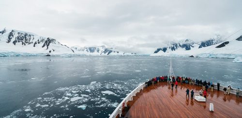
- 1.1 > A tourist ship on the coast of the Antarctic Peninsula. 42,000 cruise tourists visited Antarctica during the Antarctic summer of 2017/2018. That was 16 per cent more than the previous summer.
- But the fascination of the polar regions also partly reflects the fact that there is nowhere else in the world where ice, snow, biting cold and the long darkness of the polar nights present such huge challenges for life. Both in the Arctic and the Antarctic, animals and plants have developed sophisticated survival strategies and impres- sive species diversity that people want to see for themselves. The number of tourists in the two polar regions is therefore increasing, just as economic interest in the exploitation of polar resources is growing. South of the 60th parallel, the Antarctic Treaty establishes strict limits for the major economic players. In the Arctic, on the other hand, the five bordering states alone will determine what happens. The competition for raw materials and shipping routes there has already been underway for some time.
So similar and yet so different
The regions of the Earth designated as polar are those areas located between the North or South Pole and the Arctic or Antarctic Circles, respectively. The northern polar region, called the Arctic, encompasses the Arctic Ocean and a portion of some surrounding land masses. The southern polar region, called the Antarctic, contains the continent of Antarctica and areas of the surrounding Southern Ocean. The diameter of each region is 5204 kilometres because both the Arctic and Antarctic Circles maintain consistent distances of 2602 kilometres from their respective geographic poles, which are not to be confused with the Earth’s wandering magnetic poles.
On world maps the Polar Circles are generally marked by dashed lines at 66° 33' north and south latitude. This delineation was originally established based on the orientation of the sun. The Arctic Circle is thus defined as the latitude at which the sun does not set for exactly 24 hours during the summer solstice on 21 June each year. The winter solstice occurs in the southern hemisphere at the same time. Thus, the position of the Antarctic Circle is defined by the latitude at which the sun remains below the horizon for 24 hours.
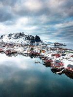 1.4 > Winter in the Arctic fishing village of Reine, in the western Lofoten Islands of Norway. Due to branches of the warm Gulf Stream, the air temperature in this part of the Arctic does not fall much below freezing.
- The many parallels observed between the Arctic and Antarctic realms should not obscure the fact that the two polar regions are fundamentally very different from each other. In the far south, Antarctica is a vast landmass – a remote continent with an area of 14.2 million square kilometres, almost twice the size of Australia. 98 per cent of this area is covered by ice up to 4700 metres thick. The continent is completely surrounded by the Southern Ocean, also known as the Antarctic Ocean or Austral Ocean. This allows an active exchange of water masses among the Atlantic, Pacific and Indian Oceans, and large areas of it freeze over in the winter (seasonal sea-ice cover). This ocean not only separates Antarctica physically from the rest of the world, its clockwise-flowing water masses also insulate the continent climatically, which is one of the reasons why large parts of Antarctica are much colder than the Arctic. As a broad comparison: The average annual temperature at the South Pole is minus 49.3 degrees Celsius, while at the North Pole it is minus 18 degrees Celsius. Furthermore, the Antarctic is considered to be the windiest and driest region on the Earth. The extreme climate here, along with its remoteness, is also the reason why very few animal and plant species have been able to establish themselves on the frozen continent. People come only to visit for a short time. Apart from research stations, there are no permanent human settlements on the Antarctic continent today.
The Arctic, by contrast, is diametrically different in several respects. Here, land masses surround an ocean that is centred on the pole. The Arctic Ocean, also known as the Arctic Sea, is connected to the rest of the world’s oceans by a limited number of waterways and, with an area of 14 million square kilometres, it is the smallest ocean in the world. In contrast to the Southern Ocean, the Arctic Ocean has a permanent sea-ice cover whose area varies with the seasons. It achieves its greatest extent at the end of winter and its smallest size at the end of summer, whereby scientists are observing a steady decrease in the extent of summer ice. Since the beginning of satellite measurements in 1979, the surface area of summer ice has shrunk by around three million square kilometres. This is an area about eight times the size of Germany. Because the continents of Europe, Asia and North America extend far into the Arctic region, the Arctic has been more successfully settled by plants, animals and people than the Antarctic. Historical evidence suggests that the first aboriginal people were hunting in the coastal regions of the Arctic Ocean 45,000 years ago. Today more than four million people live within the Arctic polar region.
Where does the Arctic begin, where the Antarctic?
The term “Arctic” comes from the Greek word arktos, which means bear. Greek seafarers called the Arctic region, into which they had presumably already ventured for the first time around 325 BC, “land under the constellation of the Great Bear”. Seamen at that time used the constellations of the northern sky, primarily Ursa Major and Ursa Minor, to aid them with orientation during their voyages of discovery.
Another celestial body, the sun, was decisive in defining a northern and later a southern polar circle as the boundaries of the polar regions. The two circles mark the geographic latitudes at which the sun does not set on the dates of the respective summer solstices. In the northern hemisphere the summer solstice usually falls on the 21st of June and in the southern hemisphere it is usually the 21st or 22nd of December. The precise positions of the polar circles are determined by the tilt angle of the Earth’s axis. Because the degree of tilt of the axis (obliquity) fluctuates slightly with a rhythm of about 41,000 years, the locations of the polar circles are also constantly shifting. They are currently moving toward the geographic poles by around 14.4 metres per year.
The Arctic Circle has never become established, however, as the definitive southern boundary of the Arctic region. This is primarily because there is no natural feature coinciding with the astronomically determined path of the Earth-encircling line that clearly distinguishes the Arctic realm from regions to the south. On the contrary, if the Arctic were limited to the regions north of the Arctic Circle, the southern tip of Greenland and large portions of the Canadian Arctic would not be included.
For this reason scientists today define the natural region of the Arctic mostly on the basis of climatic or vegetational features. One southern boundary that is often employed is the 10° Celsius July isotherm. North of this imaginary line the long-term average temperature for the month of July lies below ten degrees Celsius. By this criterion the Arctic Ocean, Greenland, Svalbard, large parts of Iceland, and the northern coasts and islands of Russia, Canada and Alaska all belong to the Arctic realm. In the air above the Norwegian Sea, the 10° Celsius July isotherm shifts northward due to the heat of the North Atlantic Current, so that, on the basis of this definition, only the northern reaches of Scandinavia are included in the Arctic. In Siberia and North America, on the other hand, cold Arctic air pushes the temperature boundary further to the south, so that regions such as the northeastern part of Labrador, the Hudson Bay, and a large portion of the Bering Sea are included as part of the Arctic
- 1.5 > On 21 June, the date of the summer solstice, the sun is at its highest elevation in the northern hemisphere. On the Arctic Circle it does not set for 24 hours, and on the Antarctic Circle it does not rise for 24 hours.
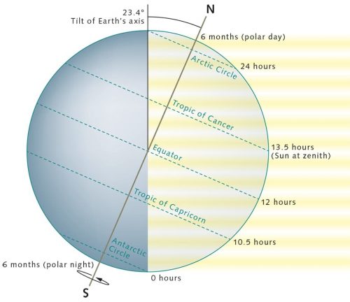
- Another natural southern boundary sometimes used for the northern polar region is the Arctic tree line. As the name suggests, the present-day climate conditions north of this line are so harsh that trees are no longer able to survive. But because, in fact, the transition from contiguous forests to the treeless grass and tundra landscapes of the Arctic is often gradual, researchers tend to refer to a zone for the boundary rather than a sharply defined line. In North America, for example, this transition zone is a relatively narrow strip. In northern Europe and Asia, however, it can be up to 300 kilometres wide. The course of the northern tree line corresponds in large part with the 10° Celsius July isotherm. In some areas, however, it can be located as much as 200 kilometres to the south of the temperature boundary. According to this definition, western Alaska and the Aleutians would also belong to the Arctic, and the Arctic region would have a total area of around 20 million square kilometres.
A third natural boundary can be delineated based on ocean currents. According to this definition, the Arctic waters begin at the point where cold, relatively low-saline surface-water masses from the Arctic Ocean meet warmer more saline waters from the Atlantic or Pacific Ocean at the sea surface. In the area of the Canadian Arctic Archipelago, the island group between North America and Greenland, this convergence zone extends to 63 degrees north latitude. As it continues eastward, it turns to the north between Baffin Island and Greenland. In the Fram Strait, the marine area between East Greenland and Svalbard, it is located as far as 80 degrees north, i.e. well to the north of the Arctic Circle. On the other side of the Arctic Ocean, in the Bering Sea, the definition of a convergence zone is somewhat more difficult, because here the water masses from the Pacific and Arctic Oceans mix extensively with each other instead of one flowing over the other. On maps, therefore, this vague boundary line runs straight across the narrow Bering Strait.
- Besides these three boundaries to the Arctic, which are all characterized by natural features, other boundaries have been defined according to different delineating criteria. Various working groups of the Arctic Council, for example, sometimes draw different boundaries. For the group of experts in the Arctic Monitoring and Assessment Programme (AMAP), for example, all of the land areas in Asia north of 62 degrees north latitude belong to the Arctic. On the North American continent they draw the line at 60 degrees latitude. The territory based on this method is significantly larger than the physiographic region defined by the tree line. The most generous definition of the Arctic is found in the Arctic Human Development Report (AHDR), where political and statistical aspects were considered in defining the area, which is why the boundary, especially in Siberia, extends further to the south than any other. According to this definition, the Arctic region has an area of over 40 million square kilometres, which is equal to around eight per cent of the total surface of the Earth.
In this World Ocean Review, the term “Arctic” will always refer to the physiographic region defined by the tree line on land and by the convergence zone in the seas. If, in special cases, other definitions of the Arctic region are necessary, this will be specifically pointed out.
In the southern hemisphere, the definition of the boundary is not as difficult. The fact that the continent of Antarctica is essentially an island and the presence of distinctive ocean currents allow a relatively clear delineation of the boundary of the southern polar region. The word “Antarctic”, by the way, derives from the Greek word antarktiké, which means “opposite to the north”. The Antarctic realm includes the continent of Antarctica and the surrounding Southern Ocean, whereby the tip of the Antarctic Peninsula and coastal areas of East Antarctica extend beyond the Antarctic Circle. The northern boundary, therefore, is often considered to be the line at 60 degrees south latitude, which was agreed to by the signatories of the Antarctic Treaty System in 1959.
The Antarctic region becomes somewhat larger if the zone of Antarctic Convergence is used to indicate the northern boundary. This is the encircling oceanic zone where cold, northward-flowing surface water from the Antarctic meets warmer southward-flowing water masses from the north. The cold, saline water sinks as a result of the density differences, and is diverted beneath the warmer water masses. For polar researchers the 32 to 48 kilometre-wide zone of the Antarctic Convergence represents the northern edge of the Southern Ocean because it clearly separates the Antarctic region from lower-latitude waters, and it delineates the natural biological associations of the two marine regions. Generally, the convergence zone is located at a latitude of around 50 degrees south, which means that this boundary definition would also include within the Antarctic region some subantarctic islands such as South Georgia and the South Sandwich Islands. The precise position of the convergence zone, however, varies somewhat depending on longitude, the weather and time of year, and can therefore shift regionally by as much as 150 kilometres to the north or south.
This World Ocean Review will conform to the delineation of the Antarctic polar region established in 1959 by the Antarctic Treaty unless otherwise noted. It thus comprises all land and marine regions south of 60 degrees south latitude.
Wandering continents
The fact that both polar regions of the Earth are covered with ice at the same time is an exceptional situation in the 4.6 billion-year history of our planet. Only a few times in the past have the Earth’s continents been so arranged that the necessary cold climate conditions prevailed both in the north and the south. It was the migration of the continents, then, which provided the initial impetus for the icing over of the two polar regions.
The German polar researcher Alfred Wegener was the first to scientifically postulate that the continents are moving. In 1912 he published his hypothesis of continental drift, which geologists to this day have only been able to supplement and refine because Wegener’s reconstructions of continental motion were so accurate. According to his theory the outer shell of the Earth, the crust, with a thickness of up to 60 kilometres, broke apart into large plates around three to four billion years ago. Since then, these have been moving independently of one another upon the Earth’s mantle, which underlies the crust and is composed of molten rock, or magma. The plates travel at speeds up to ten centimetres per year. They collide with one another, are pushed atop one another at their margins or drift apart, creating trenches and fractures through which liquid magma can rise from the Earth’s interior. In this way, new continental or ocean crust is formed at the fractures.
Climate researchers consider continental drift to be one of the most influential factors in the history of ice formation in the polar regions. After all, the relative positions of the continents and oceans determine the patterns of air and ocean currents, and thus the distribution of heat on the planet. This applies particularly to the two polar regions, whose geological structures and subsurfaces were shaped by completely different plate-tectonic processes.
- 1.6 > From a geological point of view, the current positions of Antarctica and Spitsbergen near the poles represent only a momentary glimpse. In the past, parts of both regions have been located in the opposite hemispheres.

Antarctica – an ancient continent
In order to understand the origins of the southern polar region, it is necessary to know that the Antarctic continent actually consists of two parts: One is the relatively large, solid landmass of East Antarctica, which is composed of continental crust up to 3.8 billion years old and 40 kilometres thick. The other is West Antarctica, which comprises four considerably smaller and thinner crustal blocks. These four crustal fragments even today are not firmly connected to one another. They are constantly drifting.
Although the land mass of East Antarctica and the crustal blocks of West Antarctica lie on a single continental plate, a wide trench separates the two parts from one another. The Transantarctic Mountains, on the East Antarctic side of the trench, rise to heights well over 4000 metres and extend for a length of 3500 kilometres.
The geographic position and remoteness of Antarctica are relatively recent phenomena from a geological perspective. For most of the Earth’s history the Antarctic Plate has been positioned directly adjacent to other continents. At least twice, in fact, it has been located far from the South Pole at the centre of a supercontinent. The first time was around one billion years ago, when all of the continents united as a consequence of worldwide mountain building to form the supercontinent Rodinia. The land mass that is now East Antarctica formed its centrepiece and was located north of the Equator, presumably very near the Laurentian Plate, which was the primeval North America. Some reconstructions place it beside Australia or Mexico. Which scenario is correct is still being debated today.
Approximately 550 million years later, during the Ordovician geological period, the Antarctic Continental Plate again moved to the centre of a great continent. This time it formed the core area of the giant Gondwana continent. This land mass united all of today’s southern continents as well as the Indian subcontinent, and was positioned such that Antarctica was located between the Equator and the Tropic of Capricorn. This time it was bounded by India and Australia to the west and South America to the south.
- 1.7 > As the supercontinent Gondwana began to break apart 200 million years ago, Antarctica gradually separated from the other tectonic plates and drifted toward the South Pole.
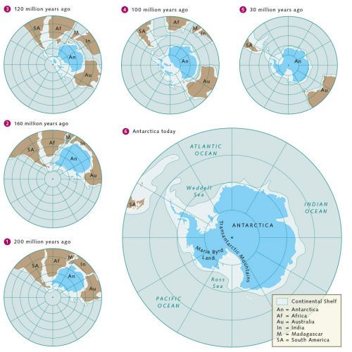
- Gondwana existed for a period of more than 300 million years. Its landscapes were characterized by widely branching river systems, lakes, dense forests, and intermittently even by a thick ice shield, which covered the continent 300 million years ago near the end of the Palaeozoic Era. Around 180 million years ago Gondwana began to break apart again – accompanied and driven by numerous volcanic eruptions, deep fractures in the Earth’s crust, and strong drift movements. These initiated the movement of the Antarctic Plate toward the south, which became possible as all of the neighbouring continents slowly broke off.
This began around 160 million years ago as the southern tip of Africa began to break away from the Antarctic continent, opening the rift that ultimately resulted in the formation of the Weddell Sea. The land masses of India and Madagascar then slowly drifted away toward the north, centimetre by centimetre. Then, between 90 and 80 million years ago, as New Zealand separated from Antarctica, the crustal blocks of West Antarctica were reorganized. Hot magma currents within the Earth began to lift the blocks along their border to East Antarctica. One consequence of this was the formation of the Transantarctic Mountains and the mountain range on Marie Byrd Land. Another was the creation of a fracture in the Earth’s crust that still exists today as a vast trench, riddled with faults and extending from the Ross Sea to the Weddell Sea. Geologists call this fault trench that runs parallel to the Transantarctic Mountains the West Antarctic Rift System. It is 800 to 1000 kilometres wide, more than 2500 kilometres long, and is one of the largest continental trench fault systems on the Earth – comparable in size to the East African Rift Valley, which runs through Africa from the Red Sea to Mozambique.
Gulf
Large marine embayments, semi-enclosed seas, or marginal seas that are largely surrounded by land masses are called gulfs. Well-known examples include the Gulf of Mexico, a marginal sea of the Atlantic Ocean enclosed by the coasts of the USA, Mexico and Cuba, and the Persian Gulf – a 1000 kilometre-long inland sea as much as 300 kilometres wide between the Persian Plateau and the Arabian Peninsula.- The Antarctic continent could someday break apart along this active fault zone, but currently the trench is only widening by two millimetres per year, which is equal to about one metre every 500 years. In the recent geological past, however, relative movements of the plates and the drifting apart of West and East Antarctica have caused the Earth’s crust to become thinner along the fracture zone and deep basins to form in the Ross Sea. This explains why large parts of the subglacial surface in West Antarctica today lie one to two kilometres below sea level, and without their unifying ice sheet would not look like a continuous surface but an assemblage of islands of various sizes.
The formation of the West Antarctic Rift zone about 80 million years ago was not the last tectonic milestone in the drift history of the Antarctic Continental Plate. Two others followed, almost synchronously with one another, and both were again driven by the spreading processes in the Earth’s crust. One occurred at the plate boundary between South America and the Antarctic Peninsula where the spreading increased significantly 50 million years ago. Around 41 million years ago the Drake Passage opened here, an oceanic strait that is about 800 kilometres wide today and connects the Pacific and Atlantic Oceans.
The second notable spreading process occurred on the other side, in East Antarctica, where Australia was drifting away from the Antarctic Plate. Researchers today find this separation fascinating because it occurred in part, at least from a geological perspective, at breath-taking speed.
It is now believed that the Australian Plate separated from the Antarctic Plate in two steps. Initially, 95 to 60 million years ago, the southern coast of Australia detached itself from East Antarctica, while the part that is now called Tasmania was still in contact with Victoria Land in the Antarctic via a land connection that was at times flooded by shallow water. This land bridge, however, already bordered on a long, shallow gulf that was formed between the two plates. Around 34 million years ago, the sea floor in the area of the land bridge subsided within a period of just one to two million years, presumably because the drift direction of the Pacific Plate had changed. A strait was created that opened a pathway for cold oceanic deep water from the Southern Ocean, which could now flow unimpeded between Australia and Antarctica. The ring of water around Antarctica was now complete and the Southern Ocean was born. The continuous band of current today still climatically insulates the southern continent from the rest of the world, and this same situation significantly contributed to the initiation of ice formation in Antarctica 34 million years ago.
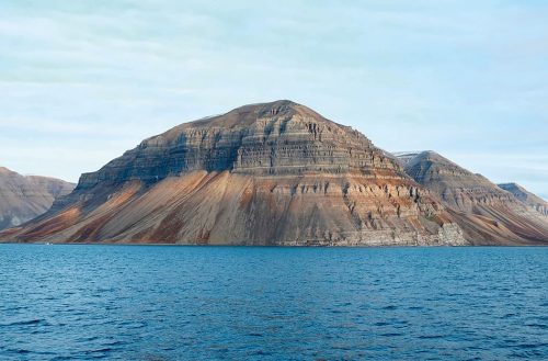
- 1.9 > Skansen Mountain, at the entrance to the Billefjorden, Spitsbergen, has clearly defined sediment layers that enable geoscientists to trace the history of the island‘s origins. The limestone layers visible here, for example, dating from the Middle Carboniferous to Lower Permian Periods, are 320 to 290 million years old.
The Arctic – an ocean opens
The land masses in the present-day Arctic region have undergone a much longer voyage than that experienced by the Antarctic continent. 650 million years ago the island of Spitsbergen, for example, as a part of a larger land mass, was located near the South Pole, as evidenced by thick glacial-period deposits that scientists can still find on the island today. Since then Spitsbergen has drifted 12,000 kilometres to the north at an average speed of less than two centimetres per year. Evidence for the wandering history is found in the various rock layers on the island.
Rust-coloured rock faces are the vestiges of a time 390 million years ago, when Svalbard was part of a large desert near the equator. 50 million years later, at the beginning of the Carboniferous Period, the region was located in the northern subtropics. The climate was hot and humid, and dense rain forests grew on Svalbard.
When the age of dinosaurs began 225 million years ago, the land mass of Svalbard was covered by a sea in which first ichthyosaurs, and a few million years later 20-metre-long plesiosaurs swam and hunted their prey. Researchers have discovered large numbers of the skeletons of both of these marine reptiles.
At the same time, rivers that existed then must have transported large amounts of sediment and organic material into the sea. These sank to the bottom and produced kilometre-thick deposits in large basins. These sediment layers play an important role today in the search for natural-gas and oil reservoirs.
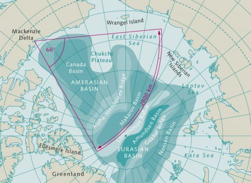
- 1.10 > The history of the origins of the Arctic Ocean has not been fully researched. One possible explanation is that the continental plates of North America and Siberia drifted apart rotationally, thereby creating room for the Amerasian Basin.
 1.11 > Palaeontologists pose beside the fossil remains of marine reptiles found on Spitsbergen.
- In the Late Jurassic epoch, 150 million years ago, plate-tectonic processes began to act that led to the formation of the Arctic Ocean and the present-day configuration of the continents. At this time, the supercontinent Pangaea split into the southern continent of Gondwana and the northern continent of Laurasia. The latter comprised the continental plates of present-day North America, Europe and Asia, a composite that likewise began to break up around 145 million years ago. Geologists believe that at that time a small ocean basin formed between North America and Siberia, which was the beginning of a division and the subsequent rotational spreading between the two plates. Based on present knowledge, the exact motions that occurred in this scenario can only be surmised. It is certain that between Canada and Alaska on one side and Siberia on the other, the present-day Arctic Ocean originated with the opening of the triangular Amerasia Basin, which is now the oldest part of the ocean.
Along the margins of this basin, Franz Josef Land, Svalbard, North Greenland and the Canadian Arctic were sites of intense volcanic activity. Liquid magma penetrated from below into the Earth’s crust to form volcanic pathways. Some lava masses also escaped to the surface and formed volcanoes.
About 110 million years ago the opening of the Amerasia Basin came to an abrupt end when the western edge of a piece of Alaska, called the Alaska-Chukotka microcontinent, collided with Siberia. At this time, Svalbard had reached its position in the high latitudes, but was still a part of the large land mass of Laurasia, which, like all of the areas surrounding the new Arctic Basin, was covered with dense forests of giant redwoods. The climate must have been very warm and the vegetation lush because thick coal deposits formed throughout these regions. On Ellesmere Island in the Canadian Arctic, scientists have found the fossil remains of turtles and crocodiles from this time. These are also indicative of the tropical conditions in the high north.
Laurasia began to break apart completely as crustal spreading between Canada and Greenland around 95 million years ago created the Labrador Sea and Baffin Bay. 40 million years later a new phase of repositioning of the continental plates began, during which the North Atlantic opened. At around the same time, 55 million years ago, an 1800 kilometre-long submarine mountain range, named after the Russian natural scientist Mikhail Vasilyevich Lomonosov, detached from the Eurasian continental margin and began to drift toward its present position at the North Pole.
In the process of this separation, the Eurasian Basin of the Arctic Ocean opened between the continental margin of Eurasia and the Lomonosov Ridge. In its centre there is an active mid-ocean ridge today, the Gakkel Ridge, named after the Russian oceanographer Yakov Yakovlevich Gakkel. This ridge is a continuation of the North Atlantic Ridge. It extends from the north coast of Greenland to near the Lena River Delta and divides the Eurasian Basin into the northerly Amundsen Basin and the Nansen Basin, which lies to the south and thus nearer to the coast.
- 1.12 > Because the two continental plates are moving away from each other, the sea floor is split open. At the opening a mid-ocean ridge has formed where magma rises from the Earth’s interior and forms new sea floor.
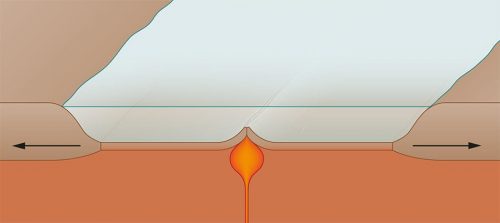
- As is typical of mid-ocean ridges, the Gakkel Ridge is a tectonic spreading zone. This means that the ocean floor is spreading apart along the 1800 kilometre-long ridge. Magma flows out of the Earth’s interior and creates new sea floor in the rift zone of the ridge. At the Gakkel Ridge these tectonic processes are occurring more slowly than at any other mid-ocean ridge in the world. The sea floor is spreading here at a rate of only one centimetre per year. Nevertheless, it is enough to explain why hot seeps simmer on the sea floor and why the Eurasian Basin is continuously growing even today.
The fragmentation of Laurasia and the opening of the Eurasian Basin over the past 55 million years have induced very complex plate motions between Svalbard and the northern margin of North America. Where plates collide, large zones of deformation and buckling occur. Mountains fold upwards – for example, on the west coast of Svalbard, in northern Greenland and in the Canadian Arctic. Where plates slide past each other, kilometre-long, box-shaped valleys form near the coasts, which are useful for geoscientists in the identification of lateral continental drift. Such fault zones exist today on Banks Island and Ellesmere Island, for instance. Researchers have found that plate movements have shaped the entire continental margin of North America over the long term. This is supported by the fact that the margin of northern Canada is surprisingly straight from the Mackenzie Delta in the southwest to the northern edge of Greenland.
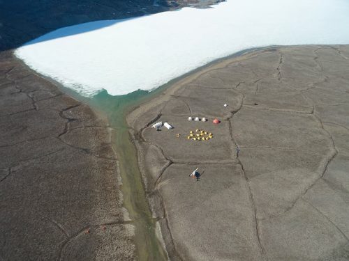
- 1.13 > In order to better understand the opening of the Arctic Ocean and the associated plate motions, geologists regularly carry out expeditions to the high latitudes of northern Canada. Here they have set up camp on a remote part of Ellesmere Island.
- Ocean formation in the Labrador Sea and Baffin Bay ended around 35 million years ago. Greenland, which had existed for some time as a separate continental plate, now became part of the North American plate again. Just ten million years later, however, Spitsbergen detached itself from northern Greenland and drifted with the rest of Eurasia into its present position.
During this separation, 17 to 15 million years ago, a trench up to 5600 metres deep was created between the archipelago and the east coast of Greenland. This deepsea trench, called the Fram Strait and named after Norwegian polar explorer Fridtjof Nansen’s research ship Fram, remains to this day the only deep-water connection between the Arctic Ocean and the world’s oceans, and is very important for the exchange of water masses.
Despite all of these geological indications, the history of the Arctic Ocean remains a plate-tectonic enigma. Many of the details are still not understood today. For example, geologists do not know the origin of the Alpha-Mendeleev Ridge. This undersea mountain chain divides the Amerasia Basin into the Makarov Basin in the north and the Canada Basin to the south. Ship expeditions to this vast marine region are extremely rare and expensive because, despite climate change, this part of the Arctic Ocean is covered with sea ice even in summer, making geological drilling particularly costly and risky.
Ice formation in Earth’s history
In terms of climate history we are living in an exceptional time. For most of the approximately 4.6 billion years since its creation, the Earth has been too warm for the formation of ice covers on large areas of either the North or South Pole. The planet has been predominately ice-free. Large-scale glaciation in the high latitudes has only occurred during the glacial periods. These are defined as times when glaciers and inland ice masses cover extensive areas of the northern and southern hemispheres. The conditions for permanently ice-covered polar regions only exist during so-called ice ages.
The present ice age began with the icing of Antarctica around 40 to 35 million years ago. For about the past million years, colder and warmer periods have been alternating at intervals of about 100,000 years. Climate researchers designate these phases as glacials (ice periods) and interglacials (warm periods).
The Earth is currently in an interglacial period. That means we are experiencing a climate with mild winters, moderate summer temperatures, and glaciers in the two polar regions and in high mountainous areas.
There is much debate about what factors trigger an ice age. What is certain is that pronounced climatic changes are always accompanied by changes in the planet’s energy balance. In general, there are four possible triggers:- cyclical fluctuations in solar activity;
- changes in the Earth’s orbital path around the sun;
- changes in the planetary albedo, the amount of solar energy reflected from the Earth back into space. This value is largely dependent on cloud cover and the lightness of the Earth’s surface;
- changes in the composition of the atmosphere, particularly the concentrations of greenhouse gases such as water vapour, carbon dioxide, methane and nitrous oxide, or the amount of particulate matter in the air.
- If one or more of these changes occurs, the various processes can work to amplify each other to some extent. A good example of this is the ice-albedo feedback: if ice sheets, glaciers and sea ice form as a result of cooling climate, the white areas of the ice surface grow larger, which increases the reflective effect from the Earth – the albedo. This means that a greater proportion of the incoming solar energy will be reflected back into space, causing the air temperature to cool further and resulting in the formation of more ice.
Beside these four main causes of climate change, however, there are additional factors that can influence the weather and climate of the Earth and thus also the extent of ice formation, either in the short or long term. These include:- meteorite impacts, short-term volcanic eruptions, and regularly occurring marine current-pattern fluctuations such as the El Niño phenomenon;
- decades-long volcanic eruptions or changes in ocean circulation;
- long-term climate swings lasting for hundreds of thousands to hundreds of millions of years, which are mainly controlled by plate-tectonic processes that result in changes in ocean circulation and the carbon cycle.
Climate extreme – snowball Earth
The largest areas of ice covered the Earth between 2.5 billion and 541 million years ago. During this time span there were repeated extremely long-term ice covers, with ice sheets and glaciers so expansive that they extended from the polar regions to the equator. This is supported by various lines of geological evidence that prompted researchers for the first time in the 1960s to suggest that the Earth must once have been under a complete cover of ice. Then, in 1992, the US American geologist Joseph L. Kirschvink formulated the hypothesis of the “snowball Earth”, which said that the continents and seas were so extensively covered with ice that the planet viewed from space at those times would have looked like a snowball. According to this theory, the global average temperature during these extreme ice periods was minus 50 degrees Celsius. At the equator, with an annual average temperature of minus 20 degrees Celsius, it was as cold as present-day Antarctica, the theory holds.
Kirschvink’s hypothesis is still widely debated today. One of the questions raised by critics is how existing organisms could have survived under a completely continuous ice cover. Another is that there is no satisfactory explanation for what processes would have been strong enough at the end of the cold period to return the climate from extremely cold back to “normal”. Nevertheless, most of the geological evidence supports the existence of at least three occurrences of these snowball conditions. The first was at 2.3 billion years ago during the Makganyene glaciation. The second one, called the Sturtian glaciation, occurred between 760 and 640 million years ago, and the third, the Marinoan glaciation, around 635 million years ago.
Extra Info Temperature fluctuations throughout Earth's history

- The triggers for these extreme climate conditions are presumed to be a combination of tectonic plate motions, significantly lower greenhouse-gas concentrations in the atmosphere, and a strong ice-albedo feedback. In the build-up to the first snowball ice period, and preceding the later snowball events as well, large land masses were located in the tropical latitudes. This concentration of continental plates near the equator initiated two processes that led to immediate cooling. For one, in regions with humid climates the rainfall led to accelerated erosion of the young rocks and mountains that had been lifted up by plate motions. Whenever rainwater fell on the bare calcareous or silicate rocks, it reacted with carbon dioxide in the air to form carbonic acid, which was then able to dissolve minerals out of the rocks and thus break them down. By this process, the greenhouse gas carbon dioxide was fixed and thus removed from the atmosphere for a very long period of time. In climate models, researchers have been able to illustrate that the global formation of ice is initiated when the atmospheric carbon dioxide concentration is less than 40 ppm (parts per million, millionths).
Secondly, the dense conglomeration of continents at the equator prevented the tropical ocean from absorbing a large amount of heat because there was less water surface available as a heat reservoir. The ocean currents therefore were not able to distribute as much heat around the globe. In addition, astrophysicists assume that since its genesis, and up to the present, the intensity of the sun has been increasing. For example, 800 million years ago the Earth was receiving six per cent less solar radiation than it is today.
Under these conditions, a large volcanic eruption ejecting millions of tons of ash particles into the atmosphere and thereby further reducing solar radiation would presumably have been sufficient to trigger the transition to a snowball state. It would only require the formation of the first glaciers. As their surface area increased, more of the incoming solar energy was reflected by the ice, thus promoting further cooling of the Earth.
Scientists can only speculate about the reasons why this spiral of cooling eventually ended. The reasons are probably related to renewed plate-tectonic movements and volcanic eruptions over a time frame of five to ten million years that increased greenhouse-gas concentrations in the atmosphere and brought a return to warmer conditions. Carbon dioxide concentrations in the atmosphere at the end of the third global glaciation reached a level of ten per cent, which is orders of magnitude greater than today’s carbon dioxide level of 0.041 per cent (410 ppm). As a consequence, the world flipped from a snowball climate into a super greenhouse climate. Within just a few thousand years, the warmth of this super greenhouse melted the Earth’s ice sheet, which probably had a thickness of up to 4000 metres. This theory is supported by characteristic rock deposits found, for example, in Oman and Australia, as well as by the results of various climate models.
Icing of the polar caps
The recent climate history of the polar regions is like a puzzle with many pieces still missing. It is fairly well known that the present ice formation in Antarctica began around 40 to 35 million years ago. At this time there was a fundamental change in the Earth’s climate. For one, a decline in atmospheric greenhouse-gas concentrations was accompanied by a drop in the air and water temperatures. Another crucial change was the opening of the Tasmanian Seaway in the southern hemisphere between Tasmania and East Antarctica, followed later by the opening of the Drake Passage. Since that time the Antarctic continent has been completely surrounded by a deep continuous pathway along which the waters of the Circumpolar Current flow. Still today they insulate Antarctica from the warm ocean currents to the north.
The first glaciers presumably formed in the high mountainous elevations of East Antarctica, specifically the mountains in the region of Queen Maud Land, the Transantarctic Mountains, and the Gamburtsev Mountain Range, which is completely covered today under the ice sheet and was named for the Soviet geophysicist Grigory Aleksandrovich Gamburtsev. Because it was cold enough at the time and sufficient amounts of snow fell, these glaciers must have grown rapidly. Climate data from deep-sea sediments suggest that Antarctica had one or more ice sheets as early as 34 million years ago that contained about half as much ice as it currently holds.
Antarctic ice masses subsequently expanded and declined depending on the development of global climate and the amount of incoming solar energy reaching the Antarctic. But the ice has never disappeared completely. The two currently existing ice sheets of East and West Antarctica attained their greatest extent at the climax of the Last Glacial Maximum about 19,000 years ago. The ice tongues extended to the outer edge of the continental shelf, and sea level was lowered by about 5 to 15 metres. By comparison, the West Antarctic glaciers extended about 450 kilometres further out into the Southern Ocean than they do today and transported so much ice that the tongues no longer floated (ice shelf), but lay on the seabed (ice sheet). The same was true for the glaciers in the Ross Sea and Weddell Sea regions. At the peak of the last glacial, global sea levels were about 120 metres lower than today.
- Since 2004, the question of timing for the onset of ice formation in the Arctic can no longer be answered with confidence. Until then it had been assumed that the large-scale formation of glaciers in the northern polar region did not begin until 2.7 million years ago, which would be more than 30 million years later than in the Antarctic. In the summer of 2004, however, in sediment cores from the Lomonosov Ridge, scientists discovered coarse rock grains in deposits older than 44 million years that could not have been transported into the ocean by either wind or water. A number of researchers have concluded that there must have been icebergs floating on the Arctic Ocean carrying this debris at that time. This assumption implies that at that time there were already glaciers near the sea from which these icebergs had calved.
Since then there has been heated debate as to whether this interpretation, that the Arctic was glaciated earlier than the Antarctic, is really correct. The presence of firm evidence that forests were growing at the time in the Arctic, suggesting a climate much too warm for glaciers,is one of the arguments against the iceberg hypothesis. Other researchers maintain that sea ice could also have transported the rock grains. As further analyses of the Lomonosov Ridge cores have revealed, the Arctic Ocean may have been covered by an initial permanent sea-ice cover long before the first ice sheets formed in East Antarctica.
The first glaciers in the northern hemisphere formed during a significant cooling between 3.2 and 2.5 million years ago. Atmospheric carbon dioxide concentrations decreased at that time from about 400 to 300 ppm. At the same time the Panama Strait closed as a result of plate tectonic movements, ending the previously continuous exchange of water between the central Pacific and Atlantic Oceans.
- The impact that this change had on Arctic climate is strongly debated. Recent and ongoing studies increasingly indicate that marine currents within the two oceans changed as a result of the interruption of water exchange between them. In the Atlantic Ocean the Gulf Stream was strengthened. Together with its branches, it now transported more saline water, heat and moisture to the far north. The surface waters cooled in the Fram Strait and then, cold and heavy, they sank toward the sea floor. These waters then travelled southward along the path of the global ocean conveyor belt. The heat and moisture above the ocean’s surface, on the other hand, was transported by the west winds toward Europe and Siberia. There, it rained and snowed with increased frequency and rivers carried much more freshwater into the Arctic Ocean. During the cold winter months, it should be noted, seawater with a greater proportion of freshwater freezes more readily into sea ice.
Climate researchers believe that more ice floes formed at that time in the Arctic Ocean. The expanding ice area likewise reflected an increasing proportion of the incoming solar radiation back into space, thus inhibiting the storage of heat energy in the ocean. At the same time, around 3.1 to 2.5 million years ago, the tilt angle of the Earth relative to the sun was changing. The planet tilted slightly more away from the sun, so that the northern hemisphere received significantly less solar radiation than it does today. The seasons became colder and less snow melted in the summer, especially in the higher altitudes. Over time the remaining snow masses compacted into firn. Eventually, the ice of the first glaciers was formed from this.
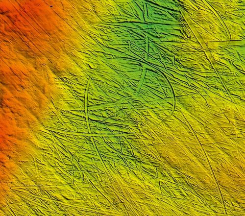
- During the subsequent glacial periods, kilometre-thick ice sheets covered large parts of North America, Europe and Siberia. Deep, parallel furrows on the seabed of the East Siberian Sea indicate that ice sheets have even formed in the Arctic Ocean itself within the past 800,000 years, not floating on the water surface like pack ice, but lying directly on the sea floor. These ice masses were at least 1200 metres thick and presumably extended over an area as large as Scandinavia.
This knowledge of the existence of such marine ice sheets raises many questions about the previous ideas regarding Arctic glaciation history. The furrows prove that large-scale freezing does not originate only at high altitudes on the continents, as was the case in Greenland, North America, northern Europe and Asia. Ice sheets can also develop in the seas. The question of what environmental conditions are necessary for this to occur, however, is one of the many uncertainties in solving the puzzle of glaciation in the polar regions.
