Oceans under threat
Multiple causes of the oceans’ critical state
Be it overfishing, marine pollution, ocean warming or acidification – today the oceans and the ecosystem services they provide are under more serious threat than ever before. The many problems caused by either regional mismanagement or global climate change render marine protection a particular challenge, which can only be met by a multitude of individual measures.
Coastal regions are acutely affected as they are par-ticularly densely populated and coastal seas are subject to intensive use. The bulk of fish are taken from coastal waters which are, moreover, the focus of drilling for natural gas and crude oil as well as intensive shipping transport. Tourism is another particular threat to coastal areas. Many coastal regions are popular holiday destinations, which often results in natural areas in these regions being destroyed for the sake of constructing hotel complexes.
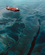
- 2.14 > When in 1989 the oil tanker Exxon Valdez ran aground near Alaska, the oil eventually covered 2000 kilometres of coastline. Several nature reserves and protected areas for birds are located in the area.
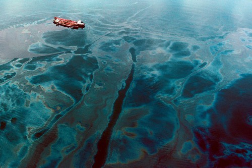
- The recognition and correct assessment of individual threats is a precondition for future sustainable ocean use. This is not always an easy feat. It is relatively easy to estimate the degree of pollution caused by a damaged oil tanker. However, it is almost impossible for researchers to determine the likely impacts of the insidious process of ocean acidification on different groups of marine life such as fish, bivalves, or molluscs.
In recent years, marine scientists have tried to identify and categorize the various aspects responsible for the mounting adverse impacts on our oceans.
The following threats and pressures are of particular significance:- Marine pollution
- Toxic substances and heavy metals from industrial plants (liquid effluent and gaseous emissions);
- Nutrients, in particular phosphate and nitrogen, from agricultural sources and untreated wastewater (eutrophication eutrophicationof coastal waters);Further information on this topic is available here:
- Ocean noise pollution from shipping and from the growing offshore industry (exploitation of oil and natural gas reserves, construction of wind turbines, future mineral extraction).
- Growing demand for resources
- Exploitation of oil and natural gas reserves in in-shore areas and increasingly also in deep-sea areas, resulting in smaller or greater amounts of oil being released into the seasmaller or greater amounts of oil being released into the sea;Further information on this topic is available here:
- Sand, gravel and rock for construction purposesSand, gravel and rock for construction purposes;Further information on this topic is available here:
- For the development of new pharmaceuticalsdevelopment of new pharmaceuticals: extraction of genetic resources from marine life such as bacteria, sponges and other life forms, the removal of which may result in damage to sea-floor habitats;Further information on this topic is available here:
- Future ocean miningocean mining(ore mining at the sea floor) which may damage deep sea habitats;Further information on this topic is available here:
- AquacultureAquaculture(release of nutrients, pharmaceuticals and pathogens).Further information on this topic is available here:
- Exploitation of oil and natural gas reserves in in-shore areas and increasingly also in deep-sea areas, resulting in smaller or greater amounts of oil being released into the sea
- Overfishing
- Habitat destruction
- Building projects such as port extensions or hotels;
- Clear-felling of mangrove forests;
- Destruction of coral reefs as a result of fishing or tourism.
- Bioinvasion
- Climate change
- Marine pollution
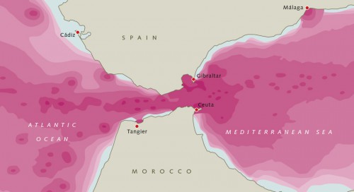
- 2.15 > Oceans are also affected by noise pollution. In 2014, French scientists for the first time produced a map depicting noise pollution in the Strait of Gibraltar which is subject to high levels of shipping traffic. The depth of the red colour indicates the noise level – the deeper the colour, the noisier the area.
- These threats have not diminished in recent year. One exception is oil pollution where changes for the better are evident: There has been a decrease in the amount of oil entering the oceans. Moreover, in Western Europe fewer nutrients are reaching the North Sea. However, for most of the other pressures there is no sign of a reversal of trends. Quite to the contrary, the threats are actually increasing.
Global threats
Many scientists take the view that ocean warming and ocean acidification, two of the effects of climate change, are having a global impact on the oceans. The cause of seawater becoming more acidic is the increase in atmospheric carbon dioxide (CO2), some of which enters the ocean, thus increasing dissolved CO2 in the seawater which leads, simply put, to the formation of carbonic acid. Laboratory experiments have shown that more acidic water renders calcium carbonate (CaCO3) structures of oceanic calcifying organisms, such as corals, bivalves, molluscs and sea urchins, more vulnerable to dissolution. There are a number of naturally occurring forms of CaCO3 which differ minimally in their chemical composition, such as aragonite and calcite, two forms of CaCO3 used by a range of marine organisms at different proportions to construct their shells or exoskeletons. The experiments have shown that those animal species which primarily use aragonite are likely to be the first to be most strongly affected by ocean acidification.
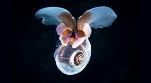
In particular, the zooplanktonic pteropods may be affected in the future; these are pea-sized “wing-footed” free-swimming sea snails. Pteropods are an important food source of fish as well as whales. Their aragonitic shells are particularly delicate and marine scientists are concerned that these shells may dissolve very quickly. Studies have shown that ocean acidification is a threat even to their offspring which may perish during their growth phase. But the shells of adult pteropods also dissolve over time.
- 2.16 > The pteropods’ thin and fragile calcified shells may dissolve as a result of ocean acidification.
- As gases such as CO2 dissolve more readily in cold water, ocean acidification proceeds most rapidly in the colder waters of higher latitudes. In cold waters, marine scientists are already seeing the first signs of the critical point slowly being exceeded at which aragonite is beginning to dissolve. For example, on expeditions conducted by the United States National Oceanic and Atmospheric Administration (NOAA) in the Pacific Ocean off the northern U.S. states of Washington and Oregon, numerous adult pteropods were caught the shells of which displayed clear signs of corrosion.
The ongoing process of ocean acidification also impacts on animal behaviour. Scientists have found that the Atlantic king scallop loses its ability to escape from predators. Normally the animals’ escape strategy involves fast shell closure and jet-like propulsion enabling them to swim out of the danger zone. With increasing acidification, however, this clapping performance weakens, thus compromising their ability to escape from predators.
What is worrying is that the two phenomena of ocean acidification and ocean warming can amplify each other. Laboratory experiments conducted by ecophysiologists studying animal metabolism have shown that some crustaceans and fish have a shortened lifespan if the water becomes both warmer and more acidic at the same time.
Coastal hotspots
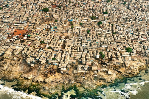
While not all marine regions are threatened by the same environmental problems, coastal regions in particular, counting amongst the world’s most densely populated areas, tend to be affected by a multitude of problems at the same time. Comprehensive marine protection in these regions would benefit a huge number of people. The United Nations estimate that today more than 40 per cent of the world’s population, i.e. more than 2.8 billion people, live within 100 kilometres of the coast. Thirteen of the world’s 20 megacities containing 10 million or more people lie along coasts. These include the cities or conurbations of Beijing (14.3), Calcutta (14.3), Dhaka (14.4), Istanbul (14.4) and Mumbai (18.2). Experts expect further increases in the urbanization of coastal areas over the coming years. They anticipate, for example, that in West Africa the 500 kilometres of already densely populated coastline between Ghana’s capital Accra and the Niger delta in Nigeria will become a continuous urban megalopolis of more than 50 million inhabitants by 2020.
The hinterland’s significance for the coast
The state of the coastal seas is dependent on both the activities taking place directly on the coast and on impacts exerted by the coastal hinterland. Some problems arise directly on the coastline, such as untreated effluent dis-charge or the destruction of the coastal strip as a result of building construction. But in many regions, large quanti-ties of pollutants also arise in the hinterland, reaching the coast via rivers or the air to be discharged into the coastal seas. These pollutants may originate far inland. The chemically highly stable fluoropolymers, for example, which are used for the production of outdoor jackets as well as grease, dirt and water-repellent paper, are released into the atmosphere from factory chimneys and travel thousands of kilometres into far distant regions. Similarly, the journey of sewage or industrial effluent contaminated with heavy metals often begins far inland. Experts estimate that land-based sources now account for 80 per cent of marine pollution including fertilizers.
It is in fact very difficult to define a clear boundary between the coast and its hinterland – where does one end and the other begin? Indeed, there is no universal definition of the term “coast”. Scientists in different fields use different criteria of relevance in this respect. Geologists may look at sediment transport from the mountains or the hinterland into coastal waters, whereas botanists researching salt marsh vegetation might have a more narrow definition of what constitutes the coast.
- 2.17 > A slum in Ghana’s capital Accra. The 500 kilometres of coastline between Ghana’s capital Accra and the Niger delta in Nigeria is expected to become a continuous urban megalopolis of more than 50 million inhabitants by 2020.
The sum of many threats: the coastal syndrome
Considering the accumulation of environmental problems on the coasts, environmental scientists have coined the term “coastal syndrome”. They use this term to demonstrate that coastal waters in many regions are showing symptoms which indicate that their ecosystem functions and services have been compromised. The scientists take into account impacts on coastal waters arising in the hinterland as well as impacts arising directly on the coast. The following aspects contribute to the coastal syndrome:
Eutrophication
In regions that are subject to intensive agricultural practices, a lot of nutrients enter the soil. These nutrients are landspread in the form of chemical fertilizers or slurry from livestock production units. Moreover, municipalities may discharge similarly nutrient-rich untreated wastewater and, in particular, excrements. By way of streams and rivers or the sewage system, excess nutrients are transported all the way to the sea. Phosphorus and nitrogen compounds in particular encourage strong algal growth, resulting in algal blooms. Ultimately, oxygen-consuming bacteria decompose dead algae. The more algae are present, the more intensive the process of bacterial degradation and the greater the oxygen demand. In extreme cases anoxic zones may result in which fish, crustaceans or bivalves can no longer survive. Examples of highly eutrophied marine areas are the Mississippi Delta at the Gulf of Mexico or the Yellow Sea on China’s east coast.
- 2.18 > Algal bloom at the Chinese coastal city of Qingdao. Helpers use fishing boats to gather up the thick green mass. Algal blooms have been occurring in the region for about the past decade. Scientists blame high levels of nutrient deposition into the sea.
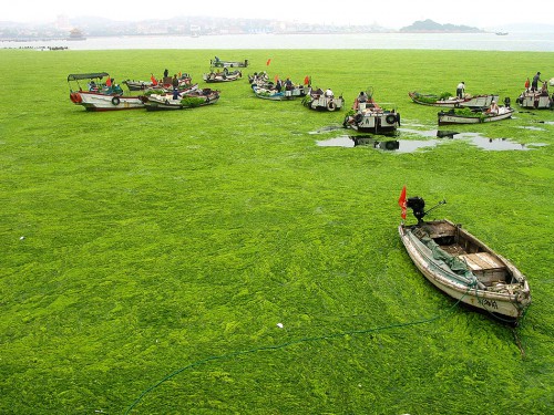
- Owing to high levels of nutrient runoff from agriculture carried by the Mississippi River, a “dead zone” has developed in recent years off the U.S. state of Louisiana, reaching a size of up to 20 000 square kilometres. In the Yellow Sea which is located between mainland China and the Korean Peninsula, massive algal blooms have become an annual occurrence since 2007. Each summer the seaweed Ulva prolifera produces a thick green floating carpet on the water surface. In the summer of 2008, the algal carpet reached an unprecedented size, swathing approximately 1200 square kilometres – twice the extent of Lake Geneva. At the height of the summer season and during the Olympic sailing events, the algal carpet floated to the Chinese urban centre of Qingdao. City officials had to remove about one million tonnes of biomass from the local beaches alone. In a recent study, Chinese scientists concluded that the amount of nutrients discharged into the Chinese coastal waters of the Yellow Sea had increased by an average of 45 per cent in the 2007 to 2012 period compared to the years 2001 to 2006.
- Research conducted in Germany has shown that it is possible to reduce the nutrient load, at least in part. Annual phosphate inputs into the North Sea watershed declined from approximately 67 000 tonnes in 1985 to 18 000 tonnes in 2005 as a result of a ban on the use of phosphorus in detergents, improved wastewater treatment in sewage plants, and optimized phosphate fertilizer applications. Over the same period, nitrogen inputs de-clined from 804 000 tonnes to 418 000 tonnes annually, primarily due to optimized fertilizer application technology. Fertilizer usage in general has improved in recent decades, with more farmers now choosing optimum timing for fertilizer applications and more products now being on the market which facilitate improved plant uptake. As a result, lesser amounts of fertilizer remain in the soil which could leach out with rainfall.
Pollution
Two intergovernmental conventions provide for internationally mandatory marine protection: The Convention on the Prevention of Marine PollutionMarine Pollutionby Dumping of Wastes and Other Matter, 1972 (London Convention, LC) and the 1996 London Protocol (LP) to the Convention, which strengthens and gives more concrete expression to the Convention’s provisions. Nonetheless the situation of many coastal regions continues to be very poor. Large quantities of a whole range of pollutants continue to reach the oceans, such as pollutants contained in untreated wastewater or exhaust air discharged from industrial plants, crude oil associated with the routine operation of drilling platforms or oil spills resulting from tanker accidents, as well as plastic litter. Plastic litter is largely land-born. Especially in areas where there is no well-organized refuse collection, litter is washed down rivers or the wind blows rubbish straight into the sea.Further information on this topic is available here:
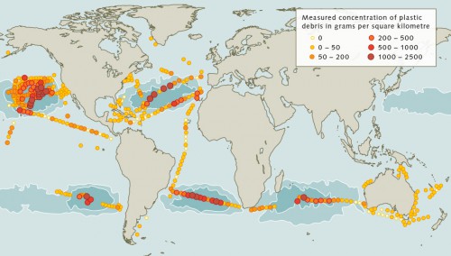
Along highly frequented shipping routes, such as the English Channel, ship waste accounts for a high propor-tion of ocean plastic litter. Global figures on the annual input of marine litter are nothing more than vague estimates. In 1997, the US Academy of Sciences estimated the total input of plastic litter into the oceans, worldwide, at approximately 6.4 million tonnes per year. This figure is likely to have risen since. Plastic litter does not only pollute coastal waters. Much of it becomes concentrated in the middle of the oceans where major sea currents converge and swirl in immense spirals which basically become flotsam-collect-ing vortexes. The largest of these areas is the Great Pacific Garbage Patch. Just how dense the concentration of litter is in this region became evident during the dramatic search for debris from Malaysia Airlines passenger flight MH370 that vanished in the Pacific Ocean on 8 March 2014. For many days, specialists attempted to spot aircraft debris using planes and satellite imagery. One false report chased another, as the searchers mistook sea trash for possible aircraft parts.
- 2.19 > The world’s oceans are polluted with varying concentrations of plastic debris. The highest concentrations of 1 to 2.5 kilograms per square kilometre can be found in the major ocean gyres, and especially in the North Pacific Ocean.
Destruction of coastal habitats
Coastal habitats, which continue to be destroyed, include wetlands, salt marshes and mudflats, coral reefs and mangrove forests. Causes of their destruction differ between regions. Wetlands, such as certain sea bays or mudflats, often fall victim to construction projects, land reclamation or coastal impounding. For example, in 2006 a 33 kilometre long seawall was completed for land reclamation purposes which cut the Saemangeum estuarine tidal flat on the South Korean coast off from the sea. Until that time, the bay had contained the world’s third most extensive area of mudflats (after the Wadden Sea on the Danish, German and Dutch coast, and the Bay of Fundy on the Canadian Atlantic coast). As a result of the seawall project approximately 400 square kilometres of mudflats were lost, an area roughly equivalent to the size of the Greek island of Naxos. While there are floodgates allowing water to discharge from the bay, the regular tidal currents have been disrupted, and with this the tidal flats have dis-appeared. In the past, Saemangeum had been one of the most important resting areas for a range of migratory bird species that breed in Siberia and overwinter in South East Asia. With the estuarine mudflats having been dammed, many birds lost this critical feeding area. Some of the rare migratory bird species have suffered major population declines as a result.
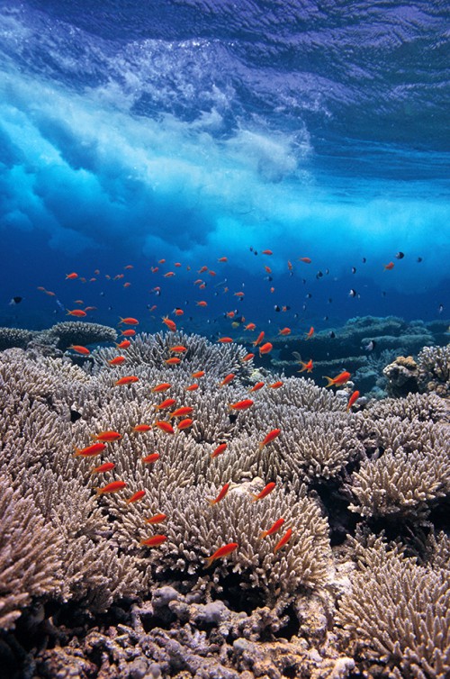
- 2.20 > Coral reefs, such as the one pictured here in the Red Sea off Egypt, are of major significance due to their species diversity. Coral reefs worldwide host somewhere between one and three million different species. However, today these ecosystems face multiple threats.
- Tropics
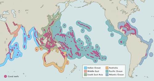
The tropics are a climate zone limited in latitude by the Tropic of Cancer in the northern hemisphere and the Tropic of Capricorn in the southern hemisphere. In some regions, corals may also occur outside of the tropical zone up to approximately 30 degrees of latitude, for example off Florida or in the Red Sea. For simplicity such corals are also referred to as tropical. Cold-water corals also exist; these are adapted to cold water, greater depths and lower light levels. Such corals occur off Norway, for instance. Map 2.22 does not take cold-water corals into account. - Similarly, many coastal wetlands around the world have been or are being destroyed. One such example are the salt marshes and reed beds in San Francisco Bay. The area is roughly the size of Manhattan and it constitutes the largest wetland on the West Coast of the United States. As much of the area has been dissected or covered by roads, bridges and settlements, a mere 8 per cent remain in a natural condition. The Sacramento Fish and Wildlife Office has now completed a management plan aimed at restoring parts of the bay.
Tropical coral reefs are also under threat. Covering only about 1.2 per cent of the world’s continental shelf area, they are highly biologically diverse ecosystems. Estimates of the total number of species of fish, bivalves, corals and bacteria on tropical coral reefs range from one million to three million. Approximately one quarter of all marine fish species inhabit tropical coral reefs. Experts have estimated that about 20 per cent of tropical coral reefs have been destroyed; a further 30 per cent have suffered serious damage. More than 60 per cent of all tropical coral reefs are currently facing at least one of the following threats from local sources:- Destruction as a result of overfishing or destructive fishing methods resulting in severe damage to corals;
- Coastal development (construction projects);
- Pollution of the seawater as a result of pollutants and sediments discharging into the marine environment from rivers;
- Pollution of the seawater at the local level as a result of direct discharges of wastewater on the coast or from commercial vessels and cruise liners, as well as physical damage to corals from groundings of ferries and tourist boats.
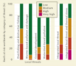 2.21 > An international team of scientists defined four categories of threats from local sources that affect tropical coral reefs. If these threats are integrated it becomes apparent that 60 per cent of reefs are at least under medium threat. When local threats are combined with thermal stress from ocean warming, this figure is as high as 75 per cent. The single most significant threats are overfishing and destructive fishing, with 55 per cent of the world’s tropical reefs under at least medium threat from these factors. Individual local threats were classified as low, medium, or high. Reefs with multiple high individual threat scores may reach the very high threat category in the summary assessment.
- If, in addition to these direct threats, the global impacts of climate change, ocean warming and ocean acidification are taken into account, experts now consider 75 per cent of all tropical coral reefs to be endangered. Ocean warming is of particular concern. Corals are dependent on symbiotic singlecelled organisms living on their surface which photosynthesize and provide nutrients that nourish the corals. If the water becomes too warm, the symbionts die first, followed by the corals. Ocean acidification is an additional stressor for corals.
At the global level, the most highly endangered coral reefs are those in South East Asia, where 95 per cent of all reefs are under pressure from at least one of the individual local threats and approximately 50 per cent are facing multiple threats. Coral reefs in Indonesia and the Philippines are particularly affected. Overfishing and destructive fishing practices are the greatest stressors in those two regions.
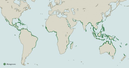
Among the coastal habitats which are highly endangered worldwide, mangrove forests are one of the most important. Mangrove trees are the only tree species that can grow directly in seawater. Their roots are either permanently submerged or anchored in damp sediment. Mangroves occur in the tropics and subtropics. Mangrove trees have developed metabolic processes allowing them to store and secrete salt taken up through their root system. Some 70 mangrove species have been documented worldwide. The highly branched submerged mangrove roots are an important habitat, supporting many species of fauna and, in particular, juvenile fish. As mangrove forests surround the coastline like a green belt, they also function as natural breakwaters and protect coasts from tsunamis and storms.
In recent years, mangroves have been destroyed in many places. Mangrove forests have often been drained and filled in to gain development land for harbours or hotels. In many regions, mangroves have also been des-troyed for shrimp farm developments. Approximately 70 per cent of the mangrove forests of Ecuador and the Philippines were destroyed for shrimp farming.
- 2.22 > Tropical corals occur in a zone extending from roughly 30 degrees North to 30 degrees South of the equator. In order to assess the threat status of the world’s coral reefs, scientists have compared the major coral reef regions.
- An additional factor contributing to the destruction of mangrove forests is timber harvesting, which threatens the livelihoods of the often poor coastal populations. The loss of mangroves entails the loss of fish nursery grounds. In many areas where mangrove forests have been destroyed, fishermen are already landing significantly less fish. And where the mangroves’ coastal protection function has been lost, storms now cause significantly more damage than they did only a few years ago.
- 2.23 > Mangroves occur in the tropics and subtropics. There are a total of 70 species of mangroves, many of which are at risk of extinction, especially species in Indonesia, the Philippines and Central America.
Overfishing
Approximately 90 per cent of the world’s wild-caught fish comes from coastal regions or exclusive economic zones (EEZ) where fishing rights solely fall to the relevant coastal state. Many nations have overexploited fish stocks in their coastal waters and EEZs in recent decades. As a result, some fish stocks have seen a drastic declinefish stocks have seen a drastic decline. According to the Food and Agriculture Organization of the United Nations (FAO) the proportion of collapsed or overfished stocks increased from 10 per cent in 1974 to 28.8 per cent in 2011. As initially many of the northern hemisphere fish stocks had been fished out, commercial fishing moved ever further south from the traditional fishing grounds in the North Atlantic and North Pacific. This situation poses difficulties on two counts: Firstly, in some regions over-exploitation undermines the livelihoods of local fishermen and deprives the local population of an important food source. This problem is known from Senegal, for instance. The Senegalese government, which has since been voted out of office, sold fishing licences to foreign-owned fishing fleets. These fleets fished the waters off the Senegal coast so intensively that the local fishers’ catches have declined massively. Secondly, intensive fishing has the capacity to alter marine food webs and in turn whole ecosystems. In the early 1990s, industrial fishing led to the collapse of the cod stocks off Nova Scotia on Canada’s east coast. Despite a moratorium on cod fishing, stocks have not really re-covered to date. It is thought that the species’ ecosystem has been perturbed to such an extent that cod recruitment is very low. Cod is a predatory fish preying on smaller, plankton-feeding species such as herring or capelin. As the cod stocks collapsed, the small plankton-feeders erupted, competing with the similarly plankton-feeding cod larvae for food sources. Moreover, predation of egg and larval stages of cod by both herring and capelin further decimated the offspring. As a result, cod stocks show little sign of recovery to date.Further information on this topic is available here:
Changes in biodiversity
Overfishing and eutrophication as well as thermal stress and acidification impact on coastal biodiversitybiodiversityand habitats. In some cases there are synergistic interactions between these factors. In other cases even just one factor strongly alters the marine environment. Eutrophication for example can affect larger species of algae that are anchored to the seabed. Increased plankton growth makes the water more turbid and reduces the amount of light reaching deeper areas. Bladderwrack Fucus vesiculosusFurther information on this topic is available here:Bladderwrack Fucus vesiculosus, for example, which anchors itself to rocks on the seafloor, has disappeared from depths of 6 to 12 metres in the Baltic Sea owing to this lack of light. It now only occurs in shallow waters with sufficient light levels. Tragically the loss of bladder wrack stands also entails the loss of habitat of juvenile fish as well as numerous other organisms living on these algae.Further information on this topic is available here:
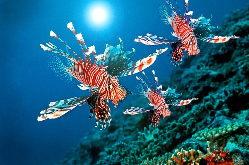
- 2.24 > The red lionfish Pterois volitans is native to Japanese waters. This predatory species has invaded Atlantic waters from Florida to the Caribbean. It is thought that the first individuals were released off the U.S. Atlantic coast in the early 1990s by aquarium owners.
- Coastal habitats also change in response to invasive alien plant and animal species, a phenomenon termed “bioinvasion” by scientists. There are generally three pathways for the introduction of non-indigenous species from one of the world’s coastal regions to another, each of which is responsible for about one third of marine bioinvasions:
- Introduction as a result of the settlement of organisms on hulls of commercial vessels (biofouling). In particular, such organisms include bivalves, molluscs and barnacles all of which directly attach themselves to the vessels’ sides. A large number of other species find shelter amongst the biofouling.
- Introduction with ships’ ballast water. Ballast water stabilizes cargo ships travelling empty of cargo. Ships take on and discharge ballast water as they load and unload cargo. Eggs and larvae of marine species may be transferred with the ballast water, as can pathogens.
- Introduction by mussel farmers or the aquarium trade. Mussel seed-stock, such as is set in oyster farms for example, spread in the areas of introduction. Other species are often attached to the seed mussels and under favourable environmental conditions these may also take hold in the new region. Owners of aquaria occasionally engage in the deliberate release of fish and other species simply to dispose of them.
- The spread in Argentina of the invasive golden mussel Limnoperna fortunei, which is native to estuaries in China, has had major economic repercussions. In the Río de la Plata basin, golden mussels displaced native species and they continue to proliferate on harbour walls and clog pipes carrying drinking water or cooling water as well as hydropower plant turbines. At great expense, they must regularly be removed from such structures with the aid of pressure washers.
It is now known that bioinvasions affect in particular harbours in the subtropics and tropics. Biomathematicians recently calculated the risk of new primary invasions between individual ports through the transfer of ballast water. To this end they analysed the logs for the years 2007 and 2008 from more than 30 000 ships, mapping each individual stop in about 1500 harbours. The scientists combined the network of global cargo ship movements with data on water temperatures and salinity in the ports. Their findings suggest that the ports and regions at greatest risk are Singapore, Hong Kong, the Panama and Suez canals, and Kaohsiung in Taiwan.
Changes in sediment transport
Just how intimately the coast and its hinterland are connected is evident from changes in sediment transport from rivers into the sea. Sediments are often deposited at the mouths of rivers, such as in deltas, where thick sediment packets may accumulate. As a result of this accumulation of sediments the lithosphere, the earth’s uppermost layer, slowly sinks. This process can have different consequences depending on the local situation. The slow increase in the thickness of sediment may compensate for the sinking lithosphere. Another possibility is that sediment transport is so strong that the sediment layer slowly grows upwards, thereby creating an ever-widening delta system as the river continuously seeks new pathways to the sea. Yet another possibility is that the sediment supply is insufficient to compensate for the sinking lithosphere, resulting in the delta region slowly subsiding and the sea level rising in relation to the land surface.
Delta subsidence can also result from the construction of dams. As the water is held back, sediment supply becomes insufficient. Worldwide more than 41 000 large dams are in operation. There are also many smaller dams and reservoirs. Together, they block 14 per cent of the total global river flow and trap enormous amounts of sediment. These trapped sediments are then not available to replenish coastal sediments, which are continuously being lost to currents and wave action, and to avoid subsidence.
- The Nile is a good example of this. Before construction of the Aswan Dam, recurrent annual floods washed fertile sediments from the interior of the continent into the Nile Delta on the Mediterranean Sea. Not only were the sediments essential for the farmers on the banks of the Nile, they were also crucial to compensating for subsidence in the heavy delta region. After the dam was built in the 1960s, the flooding and delivery of sediment came to a halt. Subsidence in the Nile Delta continues to this day. Moreover, this has resulted in saltwater intrusion into the mouth of the river and subsequent groundwater salinization. These processes in turn led to sustained crop yield reductions and massive coastal erosion. Similar problems can be expected to arise in connection with the Three Gorges Dam in China’s Yangtze Delta.
Humans have also impacted on sediment budgets in other ways. Deforestation, overgrazing and unfavourable arable systems give rise to severe soil erosion, especially in tropical regions. Rains wash elevated levels of soil into the rivers. The water then becomes turbid and water quality decreases. Increased sedimentation in the estuaries at the mouths of the rivers can smother and thus destroy estuarine sea floor habitats.
Coastal regions under threat from climate change
Many threats to coastal regionsthreats to coastal regionsoriginate in the region in question or in the coastal state’s hinterland. In contrast, climate change is a phenomenon that knows no borders and has a global impact. From the human perspective, sea-level rise in particular poses a threat. If efforts to limit carbon dioxide (CO2) emissions from the burning of natural gas, oil and coal remain unsuccessful, global warming will lead to further melting of the Earth’s ice masses. The melting of the relatively thin sea ice, which increases and decreases with the seasons in any case, is of lesser concern. Things will get critical however if the very thick ice sheets on land melt: the upland glaciers or the Greenland ice sheet. The latter covers an area of 1.8 million square kilometres, roughly 80 per cent of the surface of Greenland. Their melting would cause a significant worldwide rise in sea levels.Further information on this topic is available here:
- According to recent scientific projections, global sea-level rise to the end of this century will be in the order of 80 to 180 centimetres, unless CO2 emissions are curbed. The scientists note this with grave concern, as many people live in shallow coastal regions today. The United Nations predict that between 50 and 200 million people may be displaced by 2050 due to flooding. Worldwide roughly 700 million people live in low lying coastal areas only a few metres above sea level, or, as for example in the Netherlands, even below sea level and protected by dikes.
It is as yet uncertain in how far climate change will alter ocean currents and, in turn, winds. Similarly, it is impossible to say whether more frequent and extreme storms will occur or where that might happen. A range of mathematical climate models have reached different conclusions in this respect. While all models employ the same equations, standards of measurement and input para-meters, it is difficult to correctly assess small-scale climate impacts and to correctly transfer these into large-scale global models.
Extra Info The vicious cycle of poverty and environmental destruction

The quest for an ideal state
All in all the oceans are in a bad state now. They are over-exploited and polluted. Humankind has clearly failed to sustainably use the marine natural capital and to ensure that the oceans can continue to provide their ecosystem services in the long term. The issues have been known for a long time. While frequently the political will for sustainable development has simply not existed, much too often in the past conservation objectives were set out that were much too vague to be translated into tangible political action. A number of countries as well as the European Union are currently working on defining unambiguous sustainability targets on which appropriate political decisions are to be based. For this to happen the scientific community must provide a detailed analysis of threats and problems, enabling the political level to set the correct course towards sustainable development.
This requires that, firstly, one must determine the present status of a habitat and assess in how far it is intact or damaged by human activity. Secondly, one must define an ideal status the habitat is intended to achieve as a result of conservation measures, in other words one must describe what a habitat is supposed to be like if it was sustainably used.
The problem is that many habitats are now in poor condition. The original state these marine regions were in decades or centuries ago is not always known. Moreover, it is considered unrealistic to strive for a pristine status, unimpaired by humankind, given that most of the world’s regions have been affected and changed by human activity for centuries. Rather, it would be desirable to strive for an environmental status which, in the interest of sustainability, maintains natural capital in the long term. Therefore, the political arena and the scientific community must first define a status which can serve as a guideline and is expressive of the desired outcome of sustainable development.
Global overview
For certain marine regions, such as the North Sea, environmental analyses have of course been conducted for many years. For example, the presence of certain pollutants has been measured. However, a comprehensive worldwide analysis of the status of all oceans had long been missing. Eventually this was delivered by a working group comprising more than 65 U.S. scientists who pub-lished the Ocean Health Index (OHI). The Index initially evaluated the status of exclusive economic zones (EEZs) adjacent to 171 countries.
To establish the Ocean Health Index, the scientists articulated ten generally accepted categories that are reflective of the oceans’ sustainable ecological, economic and social significance for humankind. These are closely related to the ecosystem services categories used in the United Nations Millennium Ecosystem Assessment (MA) and include, for example, coastal protection, biodiversity, tourism and recreation, and the ocean’s carbon storage function. The fact that the sea provides humans with valuable species of flora and fauna, or special places, is also given consideration.
The scientists compiled information and comparable data with reference to the individual categories from both national statistics and international surveys. For the assessment of fish stocks the Ocean Health Index draws for example on FAO (Food and Agriculture Organization of the United Nations) data. The Index assigns a score for each of the categories, framed as goals. Each goal scores from 0 (very poor) to 100 (very good). This evaluation allows both for a ranking of the various marine regions as well as for an overall global assessment of ocean health.
The OHI results showed that the most remote, sparsely settled or little-used marine regions are the most healthy. The highest score for example was reached by the Heard and McDonald Islands, a nature reserve in the southern Indian Ocean and part of the Australian territory. In contrast, the situation is worst in seas near war-torn developing countries, such as in the marine region off the West African country of Liberia.
Strengths and weaknesses of the global analysis
The OHI is definitely considered a welcome tool that provides individual countries with an assessment of the health of their waters. Ideally the Index will inform policies based on the concept of sustainability. However, one of the difficulties in compiling a comprehensive index is the fact that errors or ambiguities may arise when such a vast amount of data is collated and processed, and thus the index may not correctly reflect reality.
Another criticism levelled at the OHI concerns the fact that simple arithmetic averages of the scores for the ten categories were calculated for the Index. Critics argue that a good score in one category can compensate for a bad score in another. For example, if a particular marine region achieves a high score of 90 points for the coastal population’s economic situation but only scores ten points for water quality, the average score is 50. At the same time, a region scoring 50 points for both goals is given the same overall score. The scoring system does not elucidate the actual differences between the two regions. Yet another criticism is that the OHI assessment method is implicitly based on the concept of weak sustainability which basically allows for unlimited substitution between depleted natural capital and other natural capital. Critics therefore call for different weightings to be applied to the categories in the calcula-tion of index scores.
Every year since its publication in 2012 the OHI has been improved and updated. The OHI no longer just covers Exclusive Economic Zones but now also includes the Arctic and Antarctica along with the High Seas. By 2014, 220 Exclusive Economic Zones were being assessed and a further 20 ocean sectors had been added to the Index. All data are published and freely accessible at the OHI website. The current global Ocean Health Index score is 67.
Concrete values for a policy of sustainability
While individual marine health index scores allow for comparisons between regions or for year-on-year comparisons of the global situation, concrete political measures call for parameters and limit values that are useful for practical application.
Efforts are currently being undertaken in Europe to define such values. These efforts are underpinned by the European Marine Strategy Framework Directive (MSFD) which came into force in 2008. The Directive’s objective is to afford better protection to the marine environment than in the past and allow already damaged marine regions to recover. The overarching goal of the Directive is to achieve “Good Environmental Status” (GES) by 2020 across Europe’s marine environment. To this end the MSFD follows an ecosystem-based approach, which considers and protects entire ecosystems rather than just individual species. Moreover, the MSFD takes account of the concept of intergenerational responsibility, a responsibility to be assumed by the current generation. The Directive defines “good environmental status” as follows: “‘Good environmental status’ means the environmental status of marine waters where these provide ecologically diverse and dynamic oceans and seas which are clean, healthy and productive within their intrinsic conditions, and the use of the marine environment is at a level that is sustainable, thus safeguarding the potential for uses and activities by current and future generations.”
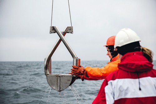
- 2.26 > On a research expedition in the Baltic Sea German scientists lift a marine bottom sampler on board containing a sediment sample. They are looking for certain species and want to find out in which of the Baltic’s sediments these species occur.
- The MSFD sets out that the evaluation and monitoring of marine waters is to be based on 11 descriptors and roughly 100 criteria and indicators. The descriptors are categories of relevance to the marine environment, such as the descriptor “eutrophication”. Each descriptor is associated with several tangible criteria. The criteria in turn are described by directly measurable indicators, which serve as limit values. One of the criteria associated with the “Eutrophication” descriptor is “Direct effects of nutrient enrichment” to which the indicators “Chlorophyll concentration in the water column” and “Water transparency” are assigned. Chlorophyll concentration is a measure of the amount of phytoplankton, which, just like terrestrial plants, contains chlorophyll. The more nutrients are contained in the water, the greater the amount of algal biomass and the higher the chlorophyll concentration, the measurement of which in a lab is quite straightforward.
However, to set appropriate individual limit values remains a major challenge. For example, to answer the question as to the maximum quantity of nitrogen a river may discharge into coastal waters, scientists must first determine the amount of nutrients a coastal region may buffer without suffering deterioration. A current corres-ponding research project on the German Baltic Sea coast shows just how difficult this is.
Guide values for the Baltic Sea have been in existence for some time. They are published by HELCOM, an intergovernmental marine environment protection commission established in the context of the Helsinki Convention by the countries bordering the Baltic. The Commission divided the Baltic Sea into 17, in part very divergent, marine regions (“sub-basins”). They range from the Kattegat which is influenced by North Sea water to the Gulf of Bothnia which freezes over in winter. HELCOM takes account of these differences by setting individual values for maximum allowable nitrogen inputs in each of the sub-basins, i.e. the maximum quantities of nitrogen a given sub-basin can take up without ill-effect.
- However, a German research project has demonstrated that this division does not give sufficient consideration to natural differences between the various coastal waters. HELCOM does not take account of the fact that when it comes to natural nutrient concentrations, there can be variations between individual Baltic coastal waters on very small spatial scales.
Given that bays, inlets (bodden) and fjords are closely connected to the land, nutrient concentrations are much higher in such waters, even in the absence of mineral fertilizer inputs, than for example in coastal segments without any bays or riverine tributaries. Therefore the threshold values as set by HELCOM proved unrealistically strict in many areas. The researchers concluded that it would be impossible to meet such low thresholds even under conditions of massive reductions in riverine nitrogen inputs. The HELCOM values therefore proved unsuitable for German Baltic waters.
The research project mentioned above has now succeeded in defining spatially differentiated thresholds which take more subtle differences between various Baltic water bodies into account and prescribe different levels of maximum allowable nitrogen inputs with reference to the individual local situation. This allows for the preparation and implementation of targeted pollution control measures in Baltic rivers.
Guidance from the nineteenth century
The MSFD proposes that the definition of what constitutes good environmental condition and the establishment of threshold values take their guidance from the situation that prevailed in the second half of the nineteenth century. At that time, European coasts had already been im-pacted by human activity, by harbours and other infrastructure, and waters were less polluted, especially owing to the fact that mineral fertilizers had not yet come into use in the farming sector. Inputs of wastewater and ex-crement were relatively low as they were limited to discharge from a small number of coastal villages and towns. Scientists are facing a problem however, given that historic data on nutrient inputs are scarce; unlike today environmental parameters were not systematically and centrally recorded.
Baltic researchers therefore turn to mathematical modelling to approximate, as much as possible, past conditions. Due to the lack of historical data they are using proxy data.
Scientists engaged in the Baltic Sea project used historical sources on land use which contain details of the extent and location of arable lands. Past crop production methods as well as the amounts of manure that were customarily applied in the past are known. Appropriate models can therefore be used to estimate past nutrient loads in rivers and coastal waters. The model shows that nutrient loads have roughly increased fourfold since then. The application of historic nutrient loads to the model demonstrates that nutrient concentrations in the Baltic were much lower than they are today, with significant regional variations in the ratios between past and present concentrations.
- The nutrient concentrations calculated by the model can not however be directly framed as target values for the present. Firstly, too little is known as to how changes have impacted on the Baltic ecosystems in terms of plankton species composition or benthic macroalgae, which means there are discrepancies between the current situation and that of the past. Secondly, nutrient inputs as low as in the reference period can not be achieved, not even in the long term, since soils have received nutrient inputs for more than 150 years. As a result of their nutrient history, today’s soils are of a different character than those of the past. Even if nutrient inputs to soils were halted today, an unrealistic proposition with a view to food production, the soils would continue to discharge elevated levels of nutrients for a long time to come. It is for these reasons that the newly calculated target values are not simply based on the lower historical values. Instead, higher target values were derived which take current measured water quality into account.
This example demonstrates just how onerous it can be, and how controversial, to define reliable indicators and determine what constitutes “good environmental status”. Generally only wealthy industrial nations and newly industrialized countries have the financial means at hand to tackle this kind of work. The countries which scored the lowest on the Ocean Health Index have neither the funds nor the expertise to carry out comparable studies.