The development of modern sea dikes
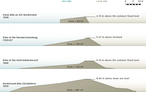
Coastal populations have always been threatened by flooding. Although fairly helpless against such events at first, over time they learned to build protective structures against storm floods. In some countries buildings were built on stilts, so that water could flow freely underneath, while in other places houses were built on man-made earthen hills. As early as the twelveth century, ring dikes were already being built in northwest Europe for the protection of individual settlements. Through time, the design of dikes changed. In the early sixteenth century the dikes in many places consisted of two-metre-high walls of timbers, backed and stabilized by an earthen wall. But because these kinds of dikes were heavily battered by the surf, the vertical form was soon abandoned in favour of an elongated slope and flatter profile, where the wave energy of the storm floods could be absorbed more gradually. In the mid-eighteenth century, these dikes often had a height of around five metres. Although the gradually sloping profile proved to be effective, water would still spill over the top during high-surging floods. This would wash out material on the back side until the dam collapsed. The trend thus developed toward the construction of increasingly higher dikes with even flatter slopes. Today, the large sea dikes in northwest Europe have heights of around nine metres. They have low slope ratios of at most 1: 6, and are around 100 metres wide at the base. These can withstand even high storm-flood surges. But with climate change and its accompanying rise of sea level, coastal inhabitants are facing new challenges.
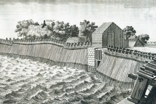
- 4.16 > For several centuries the people in the Netherlands relied on “stack dikes” (Ger. – Stackdeiche) to protect the region around Amsterdam, as shown in this illustration of the Zuiderzee in 1702. These were repeatedly damaged during heavy storm surges.
Climate change as a new challenge to coastal protection
If sea level should rise by one metre by the end of the century, and even by several metres thereafter, today’s tried and tested coastal protection systems will no longer be adequate. They will have to be upgraded in many places. No one knows, however, how strongly or rapidly climate change and sea-level rise will progress. In contrast to past centuries, when it was sufficient for engineers to design structures that were suitable for the existing conditions, precisely this question arises now in the face of climate change: What conditions will exist in the future? Coastal protection will have to account for diverse probabilities and consider the various scenarios of the IPCC (Intergovernmental Panel on Climate Change) in the planning and construction of protection systems.
- 4.17 > Through time, the profile of dikes on the North Sea coast of Schleswig-Holstein changed. There was a trend away from the steep structures to a long and much lower gradient, so that the storm-flood wave energy could gradually run out over a longer distance.
Staying a step ahead of sea-level rise
A fundamental question for coastal engineers is how high or strong coastal defence structures should be designed today. Because the future global progression of sea-level rise is uncertain, and a more rapid advance than the global average is expected in some regions, it would be prudent to incorporate flexibility into coastal protection designs for the future. An adaptive pathways approach is now being promoted. This involves the planning of coastal protection measures adapted to the short-term consequences of change, and not rigidly committed to an uncertain assessment scenario to the end of the century. In this way it may be possible to keep pace with the rising water. A large barrier that closes off a river mouth during storm floods has to be completely rebuilt when it no longer provides sufficient protection as a result of rising sea level. The initial investment would thus be completely lost. It is more sensible to plan for smaller measures that build upon one another. Coastal protection is therefore now facing a paradigm shift. While the axiom of preserving a coastline through the use of large immobile structures was considered valid in the past, the adaptive pathways design approach introduces an array of different concepts and measures, including the selective opening of dikes and the creation of emergency flood plains, or “polders”. Specialists today distinguish the following conventional and adaptive protection principles:
Conventional coastal protection
- Resistance: Planning and construction of coastal protection measures at a large economic cost, which are designed for today’s extreme events such as 100-year floods. This approach represents the classical method for designing coastal protection systems. The disadvantage is that extensive damage can result if these systems do fail, as in the breaking of a dike.
- Static robustness: Planning and carrying out coastal defence measures that are already designed for the worst-case climate scenario for today. This principle has clear disadvantages. For one, enormous investments would have to be made today. For another, the construction would be planned according to the present-day knowledge of climate change. This entails the danger that the protection measures will not be adequate if climate change becomes more intense than expected.
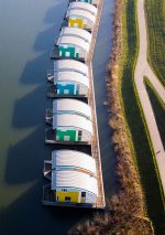
4.18 > Preparations are ongoing in the Netherlands for future flooding: Engineers have designed floating residences like these in Maasbommel. The amphibious houses are anchored to posts and can respond flexibly to high water.Adaptive coastal protection
- Resilience: Planning and construction of coastal protection structures that are designed so that their failure does not result in losses and severe damage to infrastructures, buildings or ecosystems, and allows rapid recovery or restoration. This could be achieved, for example, by building floating houses. Another possibility would be to build elevated streets and railways on the tops of dams. This would limit the extent of damage. Ideally, damage would be completely avoided.
- Dynamic robustness: Coastal protection structures are implemented in succession, to a degree that is based on the latest available knowledge about the development of climate change. This principle is based on a “no-regret” strategy. This refers to measures that would have societal benefits even when the extent of climate change turns out to be greater or less than what was expected, and that do not entail irreparable damage if false assumptions were made in the scenarios. One example of a “no-regret” measure is the creation of a “polder” that serves not only for coastal protection, but at the same time can function as a local recreation area or nature conservation area – and thus has an additional societal or ecological value. The disadvantage of this approach is that, in contrast to the concept of static robustness, the coastal protection is not fabricated in a short time by a single measure, but has to be repeatedly evaluated and expanded over a long time period by supplemental and complementary measures. It thus requires long-term and constantly adaptive planning, as well as a management system that can function over time periods of many decades and even has a planning horizon of a full century.
London leads by example
The larger bulk of coastal protection measures worldwide today are carried out according to the conventional resistance principle, but in a number of countries initial concepts are being developed that follow the adaptive pathways approach. An ongoing example is the protection of the Thames estuary in England. To protect London from flooding during storm surges, a large flood barrier, the Thames Barrier, was put into operation in 1984. It consists of large movable flood gates that are closed during storm tides and prevent the surge of high water from the sea from reaching the city. At the beginning of this century, because of concerns that the existing barrier will not be able to resist the higher storm tides expected in the future, debate began about whether it should be replaced by a new and even larger barrier further downstream within the estuary of the Thames. The ramifications for the population of London and the expected extent of damage if the barrier were to fail would be immense. The storm floods as a consequence of climate change and sea-level rise could indeed exceed the capacity of the existing Thames Barrier. They would acutely threaten 1.25 million people who live and work in the high-risk flood areas, as well as 500,000 dwellings, 40,000 commercial and industrial properties, important government buildings, 400 schools and 16 hospitals.
Polder
The term “polder” originally comes from the Dutch, signifying a piece of land that is protected from high water by dikes. In the context of coastal protection, “polder” designates areas that are purposely allowed to flood in order to diminish the crest of a flood wave.Coastal protection road map for the future
The construction of the new barrier in the Thames, which would cost up to five billion pounds, was rejected as an exclusive solution. Instead, in cooperation with scientists, the authorities created a kind of road map for future coastal protection that provides for various measures to be realized with continuing and accelerated sea-level rise, which is commensurate with the adaptive pathways approach. The Thames Estuary 2100 Plan presents a catalogue of measures, and provides clear options in dealing adequately with the risk situation at any given time, in spite of great uncertainties about the progression of climate change. Additionally, the financial burden that would result from construction of a new barrier will be avoided for as long as possible. In this developmental plan, detailed critical points in time by which decisions must be made regarding planned future measures were identified, and by which times the measures must be carried out. Furthermore, and in agreement with the surrounding counties, it was decided which measures should be carried out on various segments of the river between London and the North Sea. In chronological order, the measures include:
- Option 1: Classical defence systems
- Increase height of existing systems (sea walls, dikes, etc.);
- For old systems that need to be replaced, build the new structures higher;
- Design new defence systems so that they are more easily repaired, replaced, or raised.
- Option 2: Create floodplain areas
- Create target areas for flooding – for this purpose four large areas have already been identified in the estuarine area of the Thames.
- Option 3: New barrier
- Construction of a new barrier, for which possible sites have already been identified and the legal framework already established, so that if it becomes necessary construction can be started quickly without the need for elaborate negotiations.
- Option 4: Massive barrier
- Construction of a barrier that, in contrast to the existing one, is always closed, in order to permanently hold back the water under higher sea level conditions. This barrier will include locks for ship traffic.
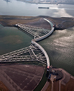
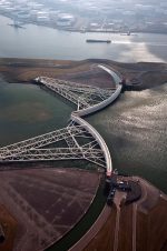
- 4.19 > Steel colossus against storm floods: after a devastating flood, often referred to as the Dutch flood disaster of 1953, dikes and barriers began to be built to defend most of the river mouths in the Netherlands. This is an image of the Maeslant Storm Barrier, which protects a part of the Rhine estuary and the harbour of Rotterdam.
The Netherlands under pressure
Because large portions of the country lie below sea level, the Netherlands and the Dutch-Belgian border region, which lies in the shallow estuarine area of the Scheldt River, are at risk in the future. Sea-level rise and the processes it triggers present a dual threat for this region. For one, it is feared that the higher storm floods associated with rising sea level will damage or spill over the dikes and protective structures. For another, with climate change, an increase in precipitation is expected for Western Europe, so inland rivers could overflow their banks more frequently. When both processes occur together – higher water levels at the coast and strong rainfall inland – the river water is no longer able to flow into the sea, so it swells and backs up in the inland regions.
Around nine million people live in the low-lying areas of the Netherlands. In addition, there is a high concentration of economic assets, comprising infrastructure as well as business and industry. The city of Rotterdam, for example, incorporating Europe’s largest harbour, presently lies an average of two metres below mean sea level. For many years now, these low-lying areas have been protected by massive structures such as dikes, dams or flood walls. Additionally, since the 1950s flood-defence systems comprising large barriers have been installed that seal off many former bays and rivers from the North Sea, either permanently or during storm surges. In order to upgrade this system to adapt to sea-level rise, expenditures have been calculated for the Netherlands of up to 1.6 billion euros annually to 2050. According to present estimates, if the massive coastal defence installations should fail in spite of these investments, and the region be flooded, the resulting losses could be as high as 3700 billion euros.
Making room for water
In view of the enormous costs for maintenance of coastal defence structures and the enormous risk that a failure of coastal protection installations entails, an additional strategy has been followed in the Netherlands since 2012 with the “Ruimte voor de Rivier” project (room for the river). While many river channels have already been highly altered by dikes and barriers, more than 30 separate measures will be carried out on the Maas (Meuse), Rhine and Waal Rivers in the Netherlands by the end of the project in 2019. These include:- Widening river beds so they can hold more water;
- Deepening of rivers;
- New construction of separate canals that will relieve the main river and provide a substantial creative landscape element for new residential areas, which would be built at the same time;
- Relocation of dikes and creation of wide polders, in order to give the high water more room.
- With these measures, the “Ruimte voor de Rivier” project also fits rather well with the concepts of the “Building with Nature” initiative, which was jointly initiated in recent years by Dutch coastal protection experts, engineering agencies, government offices, and researchers, and has already been implemented through a number of pilot projects. “Building with Nature” means that coastal and high-water protection measures are designed to conform to the natural conditions, while at the same time offering new locations for the development of natural areas. An example is the relocation of dikes for the creation of flood polders where species-rich wetlands can develop. The “Building with Nature” concept expands on conventional coastal defence systems, which could more appropriately be described as “building IN nature”. With the conventional measures, rigid artificial structures are imposed on the landscape, looking like foreign objects and often tending to slice through natural spaces.
Major project on the Scheldt estuary
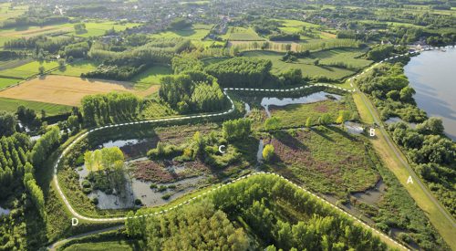
One of the first major projects to adopt the “Building with Nature” concept is the creation of a number of polders along both the Belgian and Dutch sides of the Scheldt estuary. This involves flattening all of the old dike lines to make lower overflow dikes, and moving the position of the new dike back to form a polder. The polder is bounded on the river side by the overflow dike, which only allows water to spill over at times of high water. In addition, the water level in the polder is regulated by a sluice built into the overflow dike. The purpose of the low overflow dike is to keep water in the polder to sustain wetland habitats. The polders will have a total area of 40 square kilometres. In case of high water they can take on large volumes of additional water and protect against flooding in the hinterland in the future.
- 4.20 > New polders are being built on the Scheldt estuary. The existing levee (A) is lowered to function as an overflow dike. The water level within the polder is regulated through a sluice (B) in order to form a wetland area (C). A new ring dike (D), located behind the original location, protects against high water surge.
- On around 60 per cent of the polder area wetland areas should develop naturally and will serve, among other things, as breeding grounds for birds. The first polder was created in 2006. The project is to be completed by 2030. The total costs will be around 600 million euros. Compared to this, the high-water damages that would result if the polders were not built would be significantly higher. These could be as much as one billion euros annually throughout the period to 2100.
Different coasts, different measures
As Belgian and Dutch experts point out, “Building with Nature” is possible in river estuaries and deltas as well as on sandy coasts. The latter are primarily impacted by erosion, which during the course of climate change could intensify through more frequent or higher storm floods. If buildings are present, they could be damaged or even destroyed over time. Many sandy coasts are therefore protected by massive structures. These include stone groynes in particular, which stretch from the shore out into the sea like long fingers, and considerably reduce current strength on the shore. These groynes prevent the erosion of material from the coasts during periods of strong wave activity. But this creates another problem when the primary current direction is parallel to the coast. Normally in this situation, sediment removed from one site is subsequently deposited at another location farther along the shore. It is then available to protect the sandy coast at another site. If this natural sediment transport is inhibited by groynes, other segments of the coast can be strongly eroded because the normal replenishment process is interrupted. The construction of groynes can thus lead to a deficiency of sediment somewhere else and to a gradual loss of beaches and protective dunes.
Artificial island as sediment contributor
On many coasts worldwide, beaches need to be restored by artificial filling after the storm season. This usually involves pumping sand from deeper sea-bottom areas through a pipeline onto the land, or transporting sand in with ships. This periodic filling with sand is an accepted, but laborious and expensive coastal protection measure. In the areas of sand removal and sand fill, biological communities can also be disturbed. Within the framework of the “Building with Nature” initiative, therefore, a pilot project was begun to find a different way to solve the erosion problem on a 17-kilometre-long strip of coastline in the Netherlands. To this end, a hook-shaped peninsula was filled in with a volume of 21 million cubic metres of material. This is enough sand to cover 60 football fields to a height of 50 metres. The artificial island functions as a natural sand repository that will be gradually worn away over several decades by waves, tidal currents and wind, thus providing long-term delivery of fresh sediment to the beaches on the 17-kilometre segment of coast to compensate for erosion there. This measure not only saves the construction of new massive groynes, but also the annual hydraulic filling at many sites along the coast. Thanks to this one-time filling action, it is possible to avoid repeated long-term disturbances of the ecosystem by annual sand removal.
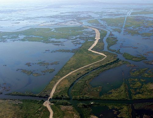
- 4.21 > Since 2013, sand from the Mississippi River at New Orleans has been pumped through a pipe for a distance of over 20 kilometres into the delta. Sand banks are created on which many square kilometres of salt marsh can develop. These, in turn, act as natural coastal protection.
- In the Mississippi Delta, off the coast of the US state of Louisiana, natural coastal protection measures of even larger dimensions are planned. The delta is heavily impacted by flooding and erosion because the amount of sediments being supplied to the delta has been severely curtailed by reservoir dams along the river. In a major project that includes more than 100 separate measures, the delta should begin to grow again and the danger of flooding be reduced.
Since 2013, for example, sand has been transported out to the delta through a pipeline more than 20 kilometres long. This sand is retrieved from the bed of the Mississippi by dredgers and pumped directly from the ships into the pipeline. Ecologically important sandbanks are created where salt marshes many square kilometres in size will develop in the coming decades and act as a natural protection for the coast. In practical terms, this should protect towns south of New Orleans from flooding. At other sites along the Louisiana coastline dunes are presently being replenished and beaches broadened by dredging.
Shellfish protect coasts
Another ecosystem-based coastal protection measure that is being employed in Louisiana, in the Netherlands, and in other coastal areas is the creation of oyster beds off the coast. These act as natural breakwaters that absorb a large portion of the energy from storm-flood waves before they reach the shore. The advantage of oyster beds is that they sustain themselves because young shellfish larvae colonize every year. Artificial breakwaters, by contrast, have to be periodically maintained and improved. In many cases, for the colonization of oyster beds wire baskets with empty shells are placed on the sea floor. These shells provide the free-swimming larvae with a firm substrate on which they can colonize and grow to mature animals. Because new larvae settle year after year, a reef is created over time.
The ecosystem-based approach – a trend with a future
The Dutch “Building with Nature” concept is now being adopted by many countries as a model for semi-natural protection from storm floods on the coasts and high waters inland. A common phrase heard in international discourse today is ecosystem-based coastal defence. In Germany, for example, as a major pilot project, a dike has been relocated on the Elbe River in south Hamburg to create the Kreetsand polder. This polder will protect the surrounding area from flooding by high inland waters that occur as a result of sustained rainfall. This project is notable because in Germany, as well as many other countries, there are still strong reservations toward ecosystem-based coastal protection, in spite of the large projects in the Netherlands. This is mainly because specialists still have relatively limited experience with these alternative measures. There is also still too little knowledge about the effectiveness of the protection and its performance over time. In addition, there are no established standards for the construction and maintenance of ecosystem-based alternatives. Thus, more trust is still placed in the classical coastal defence approach with its rigid protective structures. Moreover, our knowledge about the design and construction of classical coastal defence systems such as dikes and barriers has grown significantly over many decades. We have learned from flood catastrophes how these structures have to be designed in order to provide adequate protection even during heavy storm surges.
Practical test of alternative coastal protection
In order to better assess the efficacy of ecosystem-based solutions in practice, a number of test projects are currently underway. On the Indonesian island of Bali, for example, an ecosystem-based structure is being directly compared to a conventional rigid coastal defence structure. Bali is a popular vacation spot for tourists around the world largely because of its wide beaches and clear water. Preservation of the beauty and unspoiled nature of the coasts is thus very important both economically and socially.
The purpose of the project is to protect a stretch of coastline on the south side of Bali that is being affected by erosion. Strong wave action here carries large amounts of sediment away, and there is a lack of fresh sediment because the region is surrounded by rocky peninsulas that prevent the transport of sediment. In cooperation with coastal engineers from Europe, local agencies and the local population will compare the performance of a new protective structure made of bamboo poles and coconut-fibre mats with that of a recently built protective wall almost two metres high. Because it is known from other segments of Bali’s coast that rigid walls can actually increase erosion by altering the surf and wave activity, it is desirable to find out whether construction using natural materials is more suitable for protecting the beach from further breakdown by heavy surf. The structure consists of a series of bamboo poles, behind which the coconut-fibre mats are rolled out on the beach. To prevent them from washing away, the mats behind the poles are buried and then planted with small seedlings of a native dune grass, which form a dense network of roots over time and stabilize the structure.
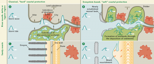
- 4.22 > While dikes or other man-made structures based on classical coastal defence concepts have to be raised to keep pace with climate change, ecosystem-based coastal protection utilizes the full natural potential of the coastal environment. Instead of setting forced limits on the water with increasingly higher dikes (A), polders can be built in estuarine areas to make more room for the sea (B). Instead of defence by groynes and sea walls (C), sandy coasts can be protected in the future through the creation of depots by artificial filling (D), which can provide the coastal areas with sand over several decades.
 This kind of direct comparison between a classical and an ecosystem-based construction with regard to their performance and effectiveness is new for the island of Bali. Because the bamboo and coconut-fibre construction has only recently been completed no information has yet been gathered regarding its effectiveness. Should the protection by bamboo and coconut-fibre mats prove to be effective, however, it would have the following advantages:
- Cost saving: In the past, specialists and labourers had to be flown to Bali for the construction of conventional coastal defence structures made of concrete. This result- ed in high costs. Construction using bamboo and coconut fibres is less expensive than a concrete structure.
- Local expertise: In the past there has been a lack of local specialists to periodically test and maintain the concrete structures, which is why they are defective in many places. Local people help, however, in constructing the systems of bamboo poles and coconut-fibre mats. They then have the knowledge and ability to provide upkeep and maintenance on the systems.
- Use of native and renewable resources: Bamboo and co-conut fibres are traditional, renewable materials that can be obtained locally. Long-distance transport is avoided.
- Creation of employment: Local employment is expanded through the construction and maintenance of the natural coastal protection systems.
- Identification with coastal protection: Because the local people themselves construct the protective structures, they have a more direct relationship to the structure and a feeling of responsibility for its preservation. When the construction is carried out by foreign companies, subsequent maintenance of the structures is often neglected.
Eelgrass – a plant with potential
One new idea for coastal protection that is to be realized as pilot projects in the coming years is the establishment of eelgrass beds. Eelgrass grows tall and prolifically, and in this respect is similar to grasses growing on land. Furthermore – in contrast to seaweed, which usually attaches to firm substrates – it produces roots that help it to withstand strong wave activity and to protect the sediments from damage and gradual erosion. While coral reefs and mangroves have long been recognized as natural breakwaters, the importance of eelgrass beds for coastal protection has only been recognized in recent years, primarily as a result of their disappearance from many coastal regions. The causes for this include water pollution and, in areas of heavy fertilizer use, high rates of algal growth, which leads to a cloudiness of the water. In areas where eelgrass has been lost, increased erosion of the sediments is often observed today. New colonization by eelgrass then becomes improbable. Seedlings can no longer get a foothold because the currents are too strong in the barren areas.
An international research team of coastal engineers, geoecologists and material scientists is therefore working on methods to facilitate the settlement of eelgrass. They are developing synthetic mats of artificial seagrass that they plan to lay out on the sea floor in the future. The artificial seagrass should reduce water currents sufficiently to allow the eelgrass seedlings to take root again. In addition, these mats are so loosely woven that the sea floor beneath them is not hermetically sealed off, so no other native organisms are harmed. While material scientists are developing a suitable synthetic composition for application in seawater, the engineers carry out experiments in a water channel at a college lab. These experiments will make it possible for the first time to quantify how efficient the damping effect of eelgrass beds can be with regard to coastal protection. A further aim is to determine how fast eelgrass seedlings can colonize.
Salt marsh and dike in a wave flume
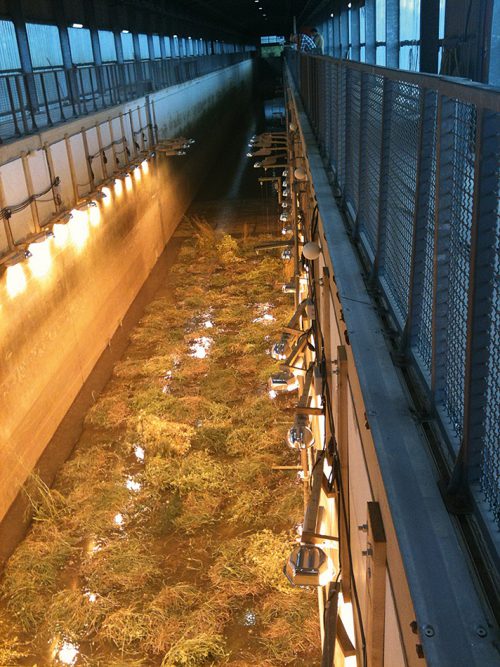
As with the eelgrass concept, there are several other ecosystem-based coastal protection approaches being considered today whose levels of effectiveness have not yet been accurately determined. This quantification is important in order to be able to assess the extent to which they will be able to supplement or even replace classical coastal defence methods in the future. Salt marshes, for example, which are located in front of the dikes at many locations along the North Sea coast, are known to slow down approaching waves during storm floods. To what extent this occurs, however, is not precisely known. So far it has not been possible to measure how effective the protective properties of heavily vegetated salt marshes are when the blades of grass are broken by the force of the waves. To make the necessary measurements, an actual patch of salt marsh from the Wadden Sea was recently removed and exposed to a strong surf in a 300-metre-long wave flume. The experiment revealed that the baffling effect was only negligibly reduced when the blades broke.
- 4.23 > Accurate measurements to determine how well a salt marsh with high-growth vegetation could reduce wave energy were made for the first time in a wave flume.
- There is a general rule in coastal protection, even today, that the turf on dikes should be kept short as possible through sheep grazing. For one reason, the ground is compacted by the treading hooves, so that the dikes do not weaken during flooding. For another, the grazing inhibits the tall growth of herbaceous plants. Strong waves could otherwise more easily rip out clusters of plants, creating holes in the dike that would then be enlarged by the wave action. In extreme cases this could lead to a breach in the dike.
For the first time coastal engineers are investigating the extent to which dikes can be seeded with various flowering plants in order to create diverse grassland biotopes. For this purpose, a dike replica of actual size is now being built in a wave tank and will be planted with various combinations of wild flowers. Storm floods will then be simulated to find out which combination forms a dense network of roots that stabilizes the turf, and which wild flowers can tolerate constant flooding by salt water.
A synthesis of old and new
More of these kinds of investigations will be necessary before ecosystem-based measures can receive wide acceptance as alternatives in coastal protection. Irrespective of this, the challenges that confront us with rising sea level in the future will have to be met with a combination of ecosystem-based and classical coastal protection methods. In the Netherlands and Germany, for example, it will not be possible to completely dispense with the use of dikes.
However, it is also evident that channelized estuaries cannot be sufficiently protected in the future by dikes alone. This has been shown through mathematical models produced by a team of Australian, German and US American researchers, which computed how wave dynamics change when the water surges higher due to sea-level rise. Under the assumption that the tidal flats will not grow proportionately to keep up with the rise of sea level, they found that the waves become higher not only by a measure equal to the amount of sea-level rise, rather their height will increase disproportionately. This is because friction with the bottom is reduced when the water level is higher. The baffling effect of the bottom is thus likewise reduced.
It is unsettling that this phenomenon already begins to become apparent when sea level is only a few centimetres higher. Because of this effect, waves could surge up to 56 per cent higher. This effect has so far not been taken into account in calculating the height of coastal protection structures. Presently only the amount by which sea level is predicted to rise in the future has been factored into the construction planning as a margin of safety.
Spheres that slow the wave surge
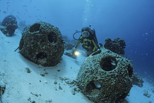
In contrast to groynes, which are built outward from the shore into the sea, breakwaters are elongate submerged structures that run parallel to the coast. They prevent the breakers from hitting the coast with unchecked strength, thus protecting beaches and promenades, for example. Today, they are typically made of massive concrete blocks or large stones in the water that otherwise have no further function. However, modules called reef balls have been in use for quite a long time and provide an ecosystem-based alternative. Hollow concrete spheres about one metre wide, made by a US American non-governmental organization, have numerous openings and not only reduce the wave energy, but at the same time provide shelter for fish and many other marine organisms. They are submerged beneath several metres of water and are ideal for organisms that colonize on firm substrates, such as mussels, sea anemones or sponges. Over time a densely settled underwater habitat is formed. Reef balls have also been set out in Germany, for example in the Bay of Kiel.
- 4.24 > Breakwaters known as reef balls. The spheres distributed by a US American non-governmental organization are deployed for coastal protection. At the same time they help to form productive submarine habitats.
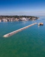
- 4.26 > The harbour of the British town of Cowes on the Isle of Wight is protected by massive breakwaters. Their construction is significantly more expensive than the creation of natural protection in the form of a salt marsh or eelgrass beds would be. Whether ecosystem-based coastal protection measures can actually be realized, however, largely depends on the form and use of a coastal area.
Is ecosystem-based coastal protection worth it?
Intact coral reefs and mangrove forests provide coastal protection at no cost, but other ecosystem-based measures can incur quite high expenditures, as demonstrated by the polder project in the Scheldt estuary. This then brings up the question of not only how reliable and effective ecosystem-based solutions are, but also how expensive they are and how high the costs are compared to classical coastal defence measures.
In a complex study, a team of international researchers analysed for the first time 52 coastal protection projects in which mangroves and salt marshes were planted or coral reefs were restored by introducing young corals. Eelgrass beds were also considered in the study. For one, they investigated how great the potential in the areas was for absorbing wave energy, and, for another, how high the project costs were compared to rigid defence measures. In a comparison of all projects, depending on the local situation, the various habitats decreased wave height as follows:- Coral reefs by 54 to 81 per cent,
- Salt marshes by 62 to 79 per cent,
- Eelgrass beds by 25 to 45 per cent,
- Mangroves by 25 to 37 per cent.
The salt marshes that were analysed, on the other hand, had widths from 100 to 2800 metres. The scientists point out, however, that in the creation of salt marshes one must take into account not only the width of the field but also the height of the vegetation. According to this study the cushioning effect in salt marshes is greatest when the vegetation height reaches up to just below the water surface.
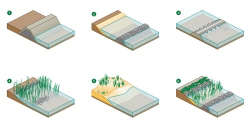
- 4.25 > Besides the classical coastal defence methods such as dikes (1), breakwaters (2), and barriers in river estuaries (3), ecosystem-based measures are being increasingly implemented today. These include the creation of man-made marshes (4) that collect fresh sediment, sand-fill areas (5) that promote the formation of sands and dunes along the coasts, and the installation of coastlines in harmony with nature (6) where species-rich green belts can develop behind structures that serve as breakwaters.
 For coral reefs, it was revealed that these have the greatest damping effect when they are at least twice as long as the incoming wave, and their tops lie at a depth of not greater than half the height of the wave.
Because there were no numbers for comparison for coral reefs and eelgrass beds, the cost analysis of the projects was limited to mangroves and salt marshes. For the latter, the study showed a clear cost advantage compared to conventional coastal defence in the form of breakwaters, and with the same damping effect. For the mangrove project, the study indicated that these can be three to five times cheaper than the construction of breakwaters. The salt marsh projects, which were primarily carried out in Europe and the USA, are either equal in cost or as much as three times cheaper than classical breakwaters, depending on the location. The differences are primarily due to the fact that the costs for breakwater construction increase disproportionately with water depth.
- 4.27 > In the Dutch resort town of Katwijk aan Zee, a parking garage was built parallel to the shore road and then covered with sand to create a high artificial dune.
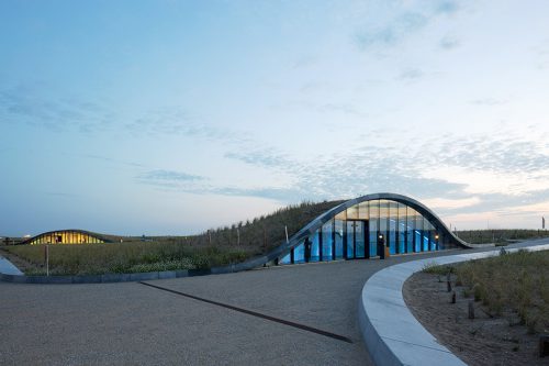
- In addition to the cost factor, the creation of mangroves and salt marshes also has the advantage that both of these habitats can grow naturally with rising sea level. Frequent flooding transports more sediment into the areas, so the bottom surface is elevated and coastal protection remains in place. Breakwaters, by contrast, lose their protective effectiveness as sea level rises.
Limitations of the ecosystem-based approach
Ecosystem-based coastal protection solutions are not suitable for all kinds of coasts. A critical exclusion criterion is the large area required for many of the solutions. The installation of polders or mangrove areas of sufficient size is impossible in the vicinity of heavily developed coastal areas or harbours. In these cases the shore could be protected by installing artificial reefs or eelgrass beds in front of the dikes. In deeper waters, however, these measures are also ineffective and the only remaining option is the rigid classical coastal defence that simply offers resistance. With rising sea level these kinds of structures have to be designed with sufficient height.
In the Netherlands, for aesthetic purposes, dikes and flood walls are planned in combination with other functions to make them, to some extent, multi-purpose structures that are integrated into the townscape but retain an aspect of coastal defence. An example is the construction of parking decks within segments of dikes or dunes, whereby the massive wall is on the sea side and serves as coastal defence, and is additionally protected by a dike or dune in front. Streets or promenades could then be built along the top of the dike. A project of this kind has been realized in the Dutch resort of Katwijk aan Zee, where a parking deck built parallel to the coast was then covered with sand and planted with typical dune vegetation. Thus, a high artificial dune was created that protects the town and is integrated harmoniously with the natural landscape.
Confronting the inevitable
Even if conventional and ecosystem-based measures are combined for effective coastal protection in the future, not all of the coasts in the world can be protected if sea level rises by several metres in the coming centuries. There is no question that people will be forced to abandon certain areas because they will be permanently flooded or uninhabitable due to frequent flooding. To begin with, this fate will befall some island nations in the South Pacific, because some of these already lie less than one metre above sea level. The governments of these island nations are now already facing the question of how the withdrawal of citizens can be organized so that the island populations can gain a foothold in a new country and achieve the same standard of living that they had in their lost homeland.
In this regard, the efforts of the government of the West Pacific island nation of Kiribati are noteworthy. On the one hand, they are continuing to promote coastal protection measures for as long as possible, especially to protect economically important facilities like the airport. But in view of the early indications of sea-level rise, such as more frequent storm floods, increasing coastal erosion and saltwater intrusion into the freshwater lenses, preparations are already being made for a future emigration.
The government of Kiribati constantly points out, on an international level, that they do not want their citizens to be considered as helpless climate refugees, rather that they are a nation combatting the results of climate change, which they are not responsible for and to which their contributions have been negligible.
Orderly retreat instead of hopeless flight
Under the motto of “migration with dignity” the former president of Kiribati, Anote Tong, initiated an emigration strategy that should enable the population to gradually build a new life in another country before the islands become uninhabitable and the approximately 100,000 inhabitants of Kiribati become homeless refugees. Together with other Pacific island nations, a strong call has been made for climate justice and support from the industrial countries – in particular, the plea to those countries is that they should offer employment perspectives to citizens of the island nations as well as permanent resident status. This outspoken pressure has led to an increase in public awareness in recent years of the hazards faced by the Pacific island nations. Nevertheless, support by the industrial countries leaves much to be desired, including by the closely neighbouring countries Australia and New Zealand. New Zealand, for example, has launched a job programme that would accommodate workers from the Pacific island nations. But New Zealand officials do not want this to be perceived as a climate relief programme. Furthermore, the number of immigrants accepted is very low. From Kiribati, based on a lottery procedure, only 75 families are allowed to immigrate each year. If the immigrants make an effort to find employment they are given permanent resident status. Beyond this, New Zealand has been offering the inhabitants of Kiribati seasonal employment in agricultural jobs since 2007. Although permanent residency permits have resulted from these measures in some cases, it certainly cannot be viewed as a broad-based climate relief programme so far. Kiribati and other island nations are calling for unambiguous assurances from the industrial nations.
- 4.28 > The inhabitants of Nukunonu island in the South Pacific do not want to be seen as climate victims, but as warriors struggling against a rising sea level. According to a UN report, the atoll, which belongs to the island group of Tokelau, could be submerged in the twenty-first century.

- While other industrial nations have so far shown even less willingness to assure rights of residency to the inhabitants of island nations threatened by sea-level rise, there is a remarkable degree of solidarity among the Pacific island nations themselves. The island nation of Fiji, for instance, has sold Kiribati around 24 hectares of land. Many of Fiji’s islands are higher in elevation than those of Kiribati, so they will be less impacted in the future by sea-level rise. Initially this area, which is located on Fiji’s second-largest island, Vanua Levu, will be used for agricultural purposes. Kiribati wants to plant food here when their own agricultural areas are lost to flooding. If parts of the Kiribati Islands become completely uninhabitable in the future, the affected Kiribati natives will be able to settle on this land. The president of Fiji has given a public verbal promise of this.
One advantage of this settlement policy is that the emigrants from Kiribati will find living conditions on Vanua Levu similar to those in their homeland. The willingness of the Fiji government to accept refugees is even more remarkable considering that some of the Fiji islands themselves will be affected by flooding like Kiribati. Fiji will therefore also have to cope with the resettlement of internally displaced persons. According to present plans, these people will also settle for the most part on Vanua Levu.
New homeland for millions of people?
The example of Kiribati illustrates that it is possible for people, with advance planning, to leave threatened coas- tal areas in time to be able to build a new livelihood with dignity in another location. Critics, however, raise the concern that there must be assurances that not only a well-educated minority, but the entire population will have the opportunity to emigrate. It is also uncertain to what extent the example of Kiribati can be applied to other countries. The approximately 100,000 inhabitants of Kiribati may be completely taken in by other countries. By contrast, many millions of other people living in areas threatened by flooding, in Bangladesh for example, cannot readily be absorbed by the densely populated neighbouring countries. Many experts are therefore calling for higher levels of international solidarity with respect to the impacts of sea-level rise, particularly on the part of industrial nations.
An initial positive step in this direction is the Nansen Initiative, launched jointly by Norway and Switzerland in 2011 and named after the first High Commissioner for Refugees of the former League of Nations, Fridtjof Nansen. The work of the Initiative consists of advising various nations regarding the problems of climate refugees and involving political representatives of the industrial nations as well as those of the developing and emerging countries, which are usually the ones most affected, in the consultation process. Above all, the aim is to mediate among the countries – those from which the people are fleeing and those that are potential destinations for the refugees. The Initiative is active worldwide, both in inland areas where, for example, people are escaping from drought, as well as on the coasts. In the past it has initiated large consultation meetings in various regions, where the public authorities and affected people sat together at one table. The Nansen Initiative has now been renamed as the Platform on Disaster Displacement. This body continues the work of the Initiative, and is supported by governmental institutions such as the Swiss Confederation and the Department of Foreign Affairs of the Federal Republic of Germany, among others.
