
Coastal functions
Close bonds between people and coasts
Coasts have been a significant human habitat for millennia. Initially the transition between land and sea functioned merely as a natural barrier. In time, though, people came to appreciate the advantages of the coastal region. From the earliest times, coastal waters supplied such resources as fish, algae or salt. As simple fishing boats were developed, coastal inhabitants became increasingly mobile. Fishers who were familiar with the ocean can largely be credited with venturing further out to sea and gradually discovering the islands along their native coastlines.
Early evidence of this exploration is found in China, for example. Archaeological finds in and around the southern Chinese city of Guangzhou indicate that by around 6500 BC, people in that area were using dugouts to navigate the expansive Pearl River Delta as well as open waters off the coast. From bases in the newly discovered territories, the more nautically experienced adventurers pushed ever further into previously unexplored sea regions. In time they discovered different cultures with different foods and tools at their disposal. Goods were exchanged between the different coastal peoples. This gave rise to the development of trading routes, which no longer just linked together coastal settlements but reached far inland via the traders involved.
- 2.1 > Excavations on the Isthmus of Corinth in the 1960s exposed a 2600-year-old portage cartway.


- Trading focused mainly on goods and resources that were important for everyday life. In Cyprus, for example, remnants have been found of knives made from the glass-like volcanic rock obsidian and dating from the period around 6000 BC. Since this rock does not occur on Cyprus, it must have arrived there from overseas during that period. Archaeologists suspect that it came via a Neolithic settlement on the Anatolian plateau, which had several thousand inhabitants at the time and was 150 kilometres away from the Mediterranean. Today the excavation site, named Çatalhöyük, has been listed as a World Heritage Site by UNESCO (United Nations Educational, Scientific and Cultural Organization). The obsidian itself must have come from the Göllü Da˘g volcano, located another 200 kilometres east of Çatalhöyük.
Other early evidence of maritime coast-to-coast trading routes is found in the Middle East. Inscriptions from Mesopotamia, a region extending over parts of modern day Iraq and Syria, indicate that as early as 2300 BC, Indian mariners were transporting copper, timber, ivory and pearls from the highly developed Indus valley into western Asia. On that evidence, a kind of long-distance trading across the sea developed in very early times.
Coastal links
In the centuries that followed, maritime trade in Europe and Asia became increasingly important. Initially, strong regional trading zones emerged – for example, around the East China and South China Seas and around the Mediterranean. In the Eastern Mediterranean the traders along the most heavily frequented shipping routes sought ways of shortening the routes very early on. Around 600 BC a paved roadway known as the Diolkos was built across the Isthmus of Corinth so that ships could be portaged overland from the Gulf of Corinth to the Saronic Gulf. This shortcut at the narrowest part of the land bridge made it possible to avoid the 400-kilometre detour around the Peloponnese peninsula. The portage road remained in use in the first century AD until ships became large and fast enough to make it redundant.
- 2.2 > In the third century BC the most important powers in the western Mediterranean were Carthage, Rome and Greece. Rome especially expanded its sphere of influence in the following centuries.


Supremacy in the Mediterranean
Coastwise trade was not solely about the pure exchange of goods, but also about gaining economic supremacy in a region. Time and time again, coastal dwellers fell into disputes over strategically important trading posts or mineral deposits, which not infrequently led to military conflicts. This is exemplified by the conflict lasting more than 300 years between the two main powers on the Mediterranean – the Romans and the Carthaginians. In the sixth century BC both powers were already vigorously engaged in commerce. Carthage dominated the area in the north of present-day Tunisia and traded predominantly in the western Mediterranean. At that time, Rome was beginning to expand its territorial dominion beyond the Apennine Peninsula. To avert competition, the two empires concluded several agreements over the course of time. The very first was negotiated around 500 BC and clearly defined each empire’s sphere of influence. The Romans were not permitted to proceed westward along the North African coast beyond a certain point north of the city of Carthage. If Roman merchants wished to conduct business in the Carthaginian territories in North Africa and on Sardinia, they could only do so in the presence of a Carthaginian official. In the western part of Sicily ruled by Carthage, on the other hand, Roman merchants were given equal standing with Carthaginians. For their part, the Carthaginians gave an undertaking not to attack Roman ruled cities in Latium, the region around the city of Rome.
- 2.3 > To this day the emblems of Amalfi, Genoa, Pisa and Venice adorn the flag of the Italian Navy. The erstwhile city-states, whose growth owed much to a fortunate combination of ocean, city and hinterland, reached the heights of their prosperity in the Middle Ages.


- Since both empires were still expanding, further treaties followed in 348 and 306 BC. These affirmed that both Rome and Carthage should respect each other’s extended territories. Among other concessions, Carthage was granted sovereignty over Libya and Sardinia.
In the ensuing years Rome proceeded to expand, ultimately dominating the entire Apennine Peninsula. The old rivalry persisted, however. Finally it erupted into a series of conflicts known as the Punic Wars, from which the Roman Empire emerged victorious in 146 BC. The city of Carthage was completely destroyed. From that time onward, Rome enjoyed a long period as the dominant power in the Mediterranean.
From the fifth century AD, the Roman Empire fell into decline. In the aftermath, various Islamic peoples rose to prominence around the Mediterranean and in the Middle East. Cities that became important trading posts at that time were the Syrian city of Damascus, the city of Cairo’s precursor settlements, Isfahan in present-day Iran, and Baghdad, later the capital of Iraq – inland cities which were nevertheless centres for the bulk of the trade between the coasts of the Mediterranean and China and India. For several centuries, Muslims controlled the trading routes along the North African coast, the Mediterranean, and the Red Sea which gave access to the Indian Ocean. In the view of historians, their great accomplishment is to have linked the trading routes of central and western Asia and the Mediterranean region into one large system.
In the early ninth century, the western Mediterranean was dominated largely by Muslim pirates who plundered the coasts and took control of Sardinia and Sicily. Christians referred to them indiscriminately as Saracens although they belonged to various Islamic peoples. The city of Amalfi on the present-day Italian Riviera was safe from the attacks due to its particular location. Situated on a steep coast on the Sorrentine Peninsula on the Gulf of Salerno, it was well protected. Its merchants succeeded in striking up business ties with the Saracens – and thus in gaining access to the important Islamic markets in North Africa. At that time the Saracens had key trading contacts with North Africa. This enabled Amalfi to grow into a major trading centre and build up a larger fleet. The city became so powerful that it eventually defeated the Saracens in the port of Ostia near Rome and significantly weakened their influence on trade in this region. Amalfi, along with Genoa, Pisa and Venice, ranks as one of the Italian maritime republics – city-states which rose to become major economic powers through astute trading and tactics, and whose trading ties reached as far as Byzantium, the empire in the eastern Mediterranean whose capital city was Constantinople, modern-day Istanbul.
Also impressive is the history of the Maritime Republic of Venice, which developed into an important economic metropolis from around the seventh century. The city had major advantages with regard to the exchange of goods. It possessed a well-established textile industry and a river port with water of considerable depth, and controlled the hinterland by means of a functioning network of rivers. Part of the reason for Venice’s dynamic development was the city’s aggressive actions towards its neighbours. Venice subjugated neighbouring competitors and controlled Dalmatia, the region that is now part of Croatia and Montenegro. Diplomatic skill, military brutality and trade boycotts targeting competitors: this was the mix with which Venice ultimately extended its sphere of influence to Crimea and Cyprus. Only in the course of the eighteenth century did the Maritime Republic decline in significance because trade in the Mediterranean no longer played such a major role. Thereafter, intercontinental trade to America and Asia took on more economic significance and was dominated by other powers such as England and the Netherlands.
The Hanseatic League – a strong alliance for 500 years
From the middle of the twelfth century, the Hanseatic League was a large trading alliance that formed in the Baltic and North Sea region, ranging from Bruges in present-day Belgium to Reval (now Tallinn) in Estonia. Originally it consisted of an alliance of merchants whose most important aim was safe passage through the coastal waters of the North Sea and the Baltic, and who joined forces for protection against pirates. Ultimately almost 300 cities in northern Europe became members.
Not all of these were on the coast; some – like Cologne, for example – were a long way inland. The success of the Hanseatic League rests particularly on the fact that it shipped goods which were only produced in certain regions to others where they were in heavy demand. Cloths, furs, wax, salt, dried or salted fish, cereals, timber and beer accounted for the bulk of the volume of goods. For some long time, textiles were the most significant commodity. The Hanseatic League was not dissolved until the mid-seventeenth century.
- 2.4 > At the end of the fifteenth century two maritime powers, Portugal and Spain, wielded such huge influence that Pope Alexander VI shared out the world between them. Territories to the west of the blue line in the Atlantic were awarded to Spain, and those to the east, to Portugal. The demarcation line was adjusted in the Treaty of Tordesillas.


Coastal prosperity and animosity
The extent to which power interests dominated merchant shipping after Christopher Columbus discovered the New World in 1492 is underlined by the way in which intercontinental trade unfolded between Europe and the ports of the newly discovered continent. The most powerful maritime nations at that time were Portugal and Spain. Spain had taken possession of the New World, while Portugal was keen to secure the newly opened trade routes to India along the African coast. Furthermore, the Portuguese had already seized Madeira and the Azores at the beginning of the fifteenth century. In 1493 Pope Alexander VI therefore issued a decree that the world beyond Europe should be divided up between Spain and Portugal. Spain received possession of the hitherto known western world and all western territories that were yet to be discovered. Portugal was allotted the eastern world. The proposed boundary between west and east was a longitudinal line in the middle of the Atlantic Ocean at the level of the 38th meridian. However, the Portuguese protested and demanded that the boundary be shifted about another 1000 kilometres to the west, i.e. approximately to the longitude of 46 degrees west. Their protest was ultimately successful; in 1494 the demarcation line was defined accordingly in the Treaty of Tordesillas. Today it is suspected that the Portuguese already knew the course of the South American coastline, because thanks to the westward displacement of the line, a large part of present-day Brazil was apportioned to Portugal. Just a few years after the Treaty, the exploitation of South America commenced. The conquered territories were turned into colonies. Large quantities of gold and silver were shipped from the New World to Europe. Important seaports for this early intercontinental cargo traffic between Europe and America were Seville and Lisbon. The Spanish fleet was the largest and most powerful of its time.
- But in the following decades, another maritime power began to stake its claim: England. The early decades of the sixteenth century saw the rising influence of an English bourgeoisie which venerated its own king, rather than the Pope, as the head of its church. Conflicts between Spain and this upstart newcomer were frequent, and in time they began to escalate. In the mid-sixteenth century, the English discovered the waters off Newfoundland to be rich fishing grounds because of the large stocks of cod to be found there. The Spaniards considered this fishing to be poaching in the waters of the western hemisphere granted to them by the Pope. Tensions rose when the Spaniards attacked English ships which were docked in the Gulf of Mexico awaiting shipyard work. Although no overt military conflicts broke out at that stage, Queen Elizabeth I sent English captains on sea raids. For a long time the conflict therefore remained more of a trade war.
Not until 1588 did a major naval battle break out between the powers. The Spanish King Philip II sent the large Spanish fleet, the Armada, to attack England and overthrow Elizabeth I. The invasion of England failed, however. The English were able to repel the Armada in the English Channel. But contrary to many accounts, the Spanish fleet was not destroyed completely. Spain remained a strong maritime power. Only a surprise attack by the Netherlands in the Bay of Gibraltar in 1607 was so resounding that Spain lost a substantial part of its fleet and its role as the strongest maritime power.
Historical shipping hubs
To trade between coasts separated by vast distances, it was necessary to establish ports on certain routes where crews could replenish their food and fresh water. Many of these ports developed into shipping hubs. One example is Mauritius. The island had been recorded on the maps of Arabian mariners since the tenth century. Portuguese sailors discovered it at the start of the sixteenth century as a stopover for their ships on their way to Asia and back to Portugal. The Portuguese only used Mauritius as a staging post, however, and did not turn the island into a colony. In the mid-seventeenth century the Dutch eventually settled on the island as colonial rulers, introducing sugarcane and commencing rum production.
- 2.6 > In 1607 Spain fought the Netherlands off the coast of Gibraltar. The Spaniards lost a substantial part of their fleet and consequently their maritime supremacy.
#/media/File: ©Battle_of_Gibraltar_1607.jpg (Stand: © 02.2017)")
#/media/File: ©Battle_of_Gibraltar_1607.jpg (Stand: © 02.2017)")
- Then, in 1715, the island was occupied by the French. They not only sold food, water and, most importantly, sugar and rum to the merchant ships that headed for Mauritius during their long voyages, but also used the prime strategic location to attack English ships in transit between Europe and Asia as they traversed the waters around Mauritius. The British put a stop to this piracy in 1810 by themselves mounting an attack on the French and taking control of the island. Thereafter Mauritius was used mainly by European merchants engaged in very active maritime trading between Europe, South America, India and South East Asia. Goods transshipped on Mauritius included textiles and spices from India, porcelain from China and ivory from Africa. Only the advent of modern motorized ships that could cover long distances non-stop, and finally the construction of the Suez Canal, caused the island’s significance to decline. In contrast, other ports managed to maintain their status as important shipping hubs for centuries. For instance, from as early as the beginning of the seventeenth century, the Dutch port of Rotterdam was an important base for the Dutch East India Company, which was active in the spice trade. From that time to this, goods from all over the world have been shipped to Rotterdam and then transported onward into mainland Europe – by ship down the Rhine, in the past, but today also by freight trains and heavy goods vehicles. Measured in terms of the volume of goods transshipped, Rotterdam ranks as the world’s sixth largest port today. Containers, natural gas and petroleum are mainly unloaded here.
Coasts develop as holiday destinations
The world’s coasts are more than just trading zones, military border zones or sources of food supply. Very early in human history, people also discovered the significance of coasts as a place of recreation, health and a wellspring of strength for the soul. In 414 BC the Greek philosopher Euripides wrote: “The sea washes away and cleanses every human stain.” He was referring particularly to the coastal zone where the elements of earth, water and wind meet. The Romans embraced the idea of the ocean’s healing power. Strolls and banquets on the beach were integral to the cultivated leisure of the aristocracy. For this sweet idleness, the Romans used the word “otium”. They did not bathe in the sea, however. Instead they established numerous thermal baths at warm volcanic springs, like those on the Italian island of Ischia which are still in use today.
- 2.7 > Back in 1907 the promenade at Brighton was already popular with visitors, and the appeal of the English coastal resort for tourists remains undiminished to this day.


 2.8 > The Hamburg shipowner Albert Ballin is acknowledged as the inventor of the cruise. In order to make better use of his passenger ships’ capacity in winter, from 1891 he began to offer cruise trips to cities all around the Mediterranean.
- In the Middle Ages, humans became more estranged from the ocean again. Despite the spread of trade between coasts, some of which were very long distances apart, the oceans were generally considered to be menacing and inhabited by monsters. The beaches of the Mediterranean were thought of as forbidding, pirate-infested territory. It was not until the seventeenth century that the ocean reverted to being a yearned-after location. One influence in this direction was the English scholar Robert Burton, whose book The Anatomy of Melancholy published in 1621 was a collection of historical and philosophical reflections from the previous 2000 years on the theme of melancholy. In this treatise he praised summer retreats beside the sea and advised those suffering from melancholy to observe the restless ocean.
The English gentry, or country nobility, also began to appreciate the importance of physical exercise in the fresh air. In the town of Scarborough on the east coast of England, acidic mineral springs were discovered in 1626. The population credited the water with healing effects, and the fame of the springs quickly spread throughout the country. By the beginning of the eighteenth century the town was developing into an established spa resort, although at first it was normally only members of the gentry who could afford to stay there.
The English doctor Richard Russell prompted a surge in popularity with his studies on the healing effect of sea water. In 1747 he settled in the seaside resort of Brighton on the south coast of England. He wrote that people with glandular illnesses would recover more quickly thanks to healing baths in the cool water, and that women suffering from physical weakness also recovered quickly. Countless people now began to travel, particularly from London, to convalesce in Brighton and it developed into one of the most popular coastal resorts in the country – no longer just for the nobility but also for members of the well-off middle classes.
Germany’s first seaside resort, Heiligendamm on the German Baltic coast, was founded in 1793. In the decades that followed, many other coastal locations in Europe turned into seaside resorts.
An entirely different kind of coastal tourism was launched by the Hamburg shipowner Albert Ballin in the 1890s: the passenger cruise, visiting a series of ports of call along the coasts. Ballin had been operating passenger ships on the route between North America and Europe for some long time. Many of those who set off in Ballin’s ships were emigrating. Since the ships were not sufficiently used in the winter period, Ballin came up with the idea of filling the ships’ capacity by offering pleasure trips to warmer regions. On 22 January 1891 the passenger ship Augusta Victoria put out to sea from Cuxhaven on the world’s first pleasure cruise. It was at sea for 57 days, 22 hours and 3 minutes, and headed for regions which sounded very exotic to most northern Europeans in those days: Egypt, the island of Malta or the port of Lisbon.

What coastlines can do
From a human perspective, coastal habitats perform a range of other functions, the “ecosystem services”, which can be categorized as follows:- Supporting ecosystem services, which are necessary for the provision of all other ecosystem services and include, for example, primary production and nutrient cycles;
- Regulating ecosystem services, which provide benefits and utility from the regulating effects of coastal waters and their ecosystems;
- Provisioning ecosystem services, which encompass products and goods for human use on the one hand and spaces provided by the sea on the other;
- Cultural ecosystem services, which include a range of functions and utility serving the nonmaterial well-being of humans.
- The concept of ecosystem services is well-suited to a systematic categorization and analysis of the multitude of services provided by coastal regions that are of material or nonmaterial benefit to humankind. However, such analyses often do not address societal issues such as, for example, the question of equitable distribution or of which societal groups benefit from services. In this respect a critical view must be taken of one-sided, purely economic assessments of ecosystem services that do not embrace sociocultural or ethical considerations.
Where habitats are considered solely with respect to the services they provide to humankind, all too often no consideration is given to the fact that every habitat can be of value whether it is utilized by people or not. Environmental ethicists speak of “non-utility value”. This includes the existence value ascribed by humans to beings such as corals or habitats such as mangrove forests regardless of whether they will ever be able to utilize or experience these organisms or habitats. The existence value is based purely on a sense of joy as to the fact that these species or habitats exist at all.
The non-utility value also includes the bequest value which is based on the human desire to pass on natural assets to future generations in as intact a condition as possible. Non-utility values, which are categorized as cultural ecosystem services, are not easily measured. Assessments of non-utility values must also obtain, for example, knowledge held by local communities and other stakeholders – such as knowledge of special religious or spiritual significance of a habitat for the population. Only if such knowledge is taken into account can the value of a habitat be measured.
- SUPPORTING ECOSYSTEM SERVICES –
THE BASIS OF FOOD WEBS
2.9 > Productive preciousness: Diatoms are among the most important primary producers. The beauty of their cell walls only becomes evident under high magnification. Microscopic samples such as these were popular souvenirs a century ago, especially among diplomats.
Small but productive
Primary production, the production of biomass by plants and microorganisms, is the basis of all marine life as well as the most important ecosystem service. Plants and microorganisms mostly obtain their energy from photosynthesis or from certain chemical compounds; they produce high-energy substances such as glucose (sugar). The most important primary producers in the oceans include microscopically small components of marine phytoplankton such as diatoms, coccolithophorid algae and cyanobacteria (formerly called blue algae). Since phytoplankton is dependent on sunlight, it lives exclusively in surface ocean waters. Similar to terrestrial plants, in addition to sunlight the phytoplankton needs nutrients such as phosphorus and nitrogen compounds. These are primarily transported by rivers into the sea. As coastal waters offer both sufficient sunlight and nutrients, they are among the particularly productive oceanic regions. This productivity also gives rise to particularly abundant fish stocks since tiny crustaceans as well as larvae of fish and bivalves feed on phytoplankton, and they in turn are a food source for fish.
However, not all the nutrients are derived from rivers. In the upwelling systems, for example, nutrient-rich cold water rises from the depths of the oceans. Such systems can be found along the coasts of Chile, California, Mauritania and Namibia. Their primary production is correspondingly high. Similar to the productive coastal waters, these upwelling systems give rise to particularly abundant fish stocks.

Seagrass meadows
Seagrass meadows are special habitats found on sandy soils in shallow waters and mudflats. While seaweeds use holdfasts to attach to rocks, seagrass sets roots with which it stabilizes sandy marine sediments. Numerous organisms, such as smaller seaweeds or molluscs, can gain hold among the plants, often making seagrass meadows particularly biodiverse habitats. Moreover, seagrass is an important food source for many species of marine fauna and waterfowl.- But the level of primary production in coastal waters is not only dependent on the nutrient quantities transported by currents and rivers but also on the intensity of water mixing. This mixing of water masses results in major variations in nutrient concentrations between different coastal segments and water depths. In the Bay of Bengal, where the Ganges and Brahmaputra form a large delta and transport a great amount of nutrients from the Himalaya Highlands into the ocean, the level of primary production changes with the monsoon. In the summer, when the moist monsoon winds blow, there is a lot of precipitation which strongly dilutes the coastal waters, thus reducing their nutrient concentration.
Another one of the world’s particularly productive coastal regions is the South China Sea. This is because the Pearl River reaches the sea west of Hong Kong. It has several tributaries and forms South China’s largest river system. Its watershed basin measures approximately 452,000 square kilometres, which is roughly equivalent to the land area of Sweden. Corresponding to the size of the river system, it transports enormous quantities of nutrients into the South China Sea.
- REGULATING ECOSYSTEM SERVICES –
PROTECTION FROM POLLUTION AND STORMS
Extra Info Transformations of a key nutrient – the nitrogen cycle

The coast – a wastewater treatment plant
Coastal waters play an important role in purifying effluent and removing pollutants conveyed by rivers and sewers and deposited from the atmosphere. They thus have a regulating function and are vital for nutrient decomposition, especially for the breakdown of nitrogen compounds. Plants need nutrients, notably nitrogen and phosphorus, in order to grow. To increase the productivity of arable land and achieve higher yields, these nutrients are applied to agricultural land in the form of slurry, sewage sludge or artificial fertiliser.
In intensive agriculture regions high levels of nutrients enter the soil as the crop plants grown tend to not fully take up the fertilizers applied. Rainwater washes these surplus nutrients into the groundwater, streams and rivers, and ultimately into the sea. The phosphorus and nitrogen compounds also increase algal growth. Where there is an oversupply of nutrients, algal growth can be so rapid that it results in pronounced algal blooms. The more abundant the algae, the more intensive is their decomposition by oxygen-consuming microorganisms in deeper water layers. This phenomenon is called eutrophication. In extreme cases it results in zones devoid of oxygen in which fish, crustaceans and molluscs can no longer survive.
With the intensification of farming, the number of oxygen-deficient or oxygen-depleted zones in coastal waters has sharply increased since the 1960s, especially in the northern hemisphere. Worldwide some 400 coastal areas are regularly affected by oxygen-deficiency; these areas cover a total of 245,000 square kilometres, which is roughly equivalent to the size of Romania. Oxygen-deficiency primarily affects coastal waters in Europe, along the eastern US seaboard, the Gulf of Mexico and increasingly also in China. The decomposition of nitrogen compounds is of particular significance in this context as these enter the seas in large quantities. Fertilizers, slurry and excrements mostly contain nitrogen in the form of ammonium ions (NH4+). In the presence of oxygen, ammonium oxidizes to nitrate. In environmental waters, microorganisms (denitrifying bacteria) convert the nitrate to gaseous nitrogen (N2) in a process called denitrification. Algae cannot use gaseous nitrogen as a plant nutrient. Thanks to denitrification, coastal waters to a certain degree function as the ocean’s wastewater treatment plants.
- 2.11 > The estuary of the Salak River on the island of Borneo is dominated by mangrove forests. They protect the coastline from hurricanes and storm surges.


- However, if the quantities of nutrients entering the ocean are too large, these can no longer be fully decomposed, thus leading to eutrophication.
The various plant communities occurring in coastal waters contribute significantly to the elimination of nutrients. These communities include, in particular, mangroves and seagrass meadows, the roots of which take up large quantities of nutrients in the same manner as terrestrial plants. Nutrient decomposition is further enhanced by the numerous organisms living in the seabed, such as molluscs or worms. Millions upon millions of these organisms live buried in the seabed. Their several centimetres long burrows give many sediments the appearance of sponges. Compared to the normally solid and dense sediment which water can only enter through the spaces between the sediment grains, the numerous burrows enlarge the surface area on which microorganisms can engage in denitrification. This significantly enhances the effluent purification function of coastal waters.
Coastal waters also have a regulating function when it comes to the decomposition or neutralization of pollutants such as persistent chemical compounds or heavy metals transported into the coastal seas by rivers or the atmosphere. The dilution of pollutants is one of the processes, while they are also sequestered into the sediment through the activities of sediment-dwelling organisms which, for example, filter pollutants from the water with their feed and subsequently deposit them in the sediment with their faeces. While the pollutants are not removed from the environment in this manner, their sequestration into the sediment prevents other marine organisms from ingesting them. Ultimately these processes also prevent pollutants from being ingested by humans through the food chain.
Taming the ocean’s force
Coastal habitats such as dunes, coral reefs and mangroves perform a key protective function for humans as they are able to break winds and swells, thus regulating the oceans’ physical forces. For example, Abidjan, the Ivory Coast town, is protected by seaward dunes, as are the Dutch city of Amsterdam, the Nigerian city of Lagos or Durban in South Africa.
The importance of mangrove forests for coastal protection has become particularly evident in recent years. Tropical storms can produce tidal waves of up to 7 metres in height. As a study conducted by British researchers has shown, mangroves provide outstanding protection against such storm surges and hurricanes. Using mathematical modelling the scientists were able to demonstrate that a one kilometre wide mangrove forest can be expected to reduce surface wind energy by 75 per cent and wave height by up to half a metre. Considering that natural mangrove forests can be many square kilometres in size, they offer significant protection, for example along the southern coastline of Florida where they cover an area of roughly 2000 square kilometres. However, mangrove forests along many tropical coasts have suffered large-scale destruction over many years. In Indonesia, for instance, they were removed to make space for aquaculture. Colombia has lost almost 20 per cent of its mangrove forests – here they fell victim to timber extraction. Studies have shown that the damage caused by the 2004 tsunami in the Indian Ocean, and especially the damage caused along the Indonesian coast, would not have been anywhere near as severe if the mangrove forests had not been cut down over many years.
- PROVISIONING ECOSYSTEM SERVICES –
FISH, DIAMONDS, AND A WHOLE LOT MORE
Aquaculture
The term "aquaculture" covers several different forms of production. Traditionally the term was used for freshwater fish production such as carp farming. However, aquaculture also includes mariculture, i.e. the cultivation of marine organisms at sea. There are now also hybrid forms in which marine animals are bred on land in special salt water tanks.Protein for a growing world population
Since time immemorial humans have eaten fish and seafood from the oceans.Since time immemorial humans have eaten fish and seafood from the oceans.For thousands of years marine fish were only consumed near the coasts as it was not possible to transport fish inland over long distances. Over time, however, processes were developed that made it possible to preserve fish. At first, fish was preserved in salt. Later it was canned, which made it possible to transport it over great distances. Only when freezing technology was invented and allowed for the almost indefinite preservation of food did fish become a staple food even far away from coastal regions. Today fish is consumed in significant quantities worldwide and plays a major role in human protein supply. This is particularly true for West African countries such as Senegal or the small island states in the South Pacific where fish is one of the most important staple foods.Further information on this topic is available here:
With the growth of the world population, the consumption of fish and seafood has increased vastly since the middle of the previous century. While in the 1960s the per capita consumption level stood at 9.9 kilograms, it passed the 20 kilograms mark for the first time in 2014, as the Food and Agriculture Organization of the United Nations (FAO) reports. This means that the consumption of fish and seafood doubled in just half a century. According to the United Nations, the world population will grow from 7 billion to approximately 9.5 billion people by 2050. More than an additional 2 billion people will need to be supplied with food and with protein in particular. Fish will contribute a significant proportion of this protein but it is obvious that wild caught fish cannot supply these additional quantities of protein if fish stocks are no longer to be subjected to overexploitation.
- 2.12 > The quantities of fish and seafood produced today are many times greater than they were in 1950. While aquaculture was insignificant at first, it now provides almost half of the global production.


- The degree to which coastal waters contribute to the supply of wild caught fish and seafood is difficult to quantify. Since the FAO’s global statistics do not differentiate between coastal waters and other waters, there are only rough estimates in the region of 90 per cent. In Europe, fisheries experts distinguish between coastal fishing, middle water fishing and distant water fishing, differentiating by size and levels of motorization of fishing vessels. Coastal fishing is dominated by smaller trawlers that are mostly 18 to 24 metres in length and have engine sizes of up to 300 HP. It overlaps with middle water fishing with trawlers that are mostly 18 to 32 metres long and have engine sizes of no more than 600 HP. Distant water fishing is carried out by even larger vessels up to and including factory ships with on-board facilities for processing and freezing caught fish.
Another definition of coastal fishing is that it is limited to the shelves – a term that describes the areas of relatively shallow water near the coastlines. The shelves slope gently to an average depth of 130 metres, ending at the break to the continental slope, which falls more steeply to greater depths. According to this definition, the fisheries in many of the shallow marginal seas, such as the East China Sea or the North Sea, would be considered coastal fisheries in their entirety, despite the fact that in purely legal terms a country’s coastal sea is limited to the 12 nautical mile zone.
Fish to feed the world
Aquaculture – the production of fish and other organisms in specialized installations – can play an important role in securing fish supplies in the future.Aquaculture – the production of fish and other organisms in specialized installations – can play an important role in securing fish supplies in the future.This form of production has grown significantly in recent years while the quantities of fish and seafood caught in the wild have hardly changed. In 2014 a total of 167.2 million tonnes of fish and seafood were consumed worldwide. Of these, 93.4 million tonnes were caught in the wild, 73.8 million tonnes originated from aquaculture production, and 26.7 million tonnes of the latter were produced at sea, exclusively in coastal waters. However, a much larger quantity, i.e. 47.1 million tonnes, now comes from land-based aquaculture installations. China accounted for the largest share of global aquaculture production at 60 per cent.Further information on this topic is available here:
- 2.13 > China contributes 60 per cent of the global aquaculture production. Aquaculture installations such as the one shown here in Tolo Harbour near Hong Kong can be found in many of China's coastal regions.


- Aquaculture must be carried out in a sustainable wayAquaculture must be carried out in a sustainable wayif it is to offer hope for the future, as major mistakes have been made in recent decades. For example, in the 1990s hundreds of kilometres of mangrove forests along the coast of Indonesia were cut down in order to establish shrimp farms in the form of aquaculture monocultures. In many places, shrimp as well as fish continue to be produced intensively and with a view to maximum yields. As a result they are more susceptible to diseases than their wild relatives and are preventively given antibiotics and other medication – with unforeseeable repercussions for the marine environment as well as for the end consumers. Another problem is the fact that the animals’ faeces lead to regional marine eutrophication, which considerably impairs water quality.Further information on this topic is available here:
Meanwhile there has been something of a shift in thinking towards environmentally sound aquaculture. Mixed aquaculture systems in which several organisms are kept together and in which the faeces of one species serve as a food supply for other organisms are regarded as a promising alternative. Such systems are termed Integrated Multi-Trophic Aquaculture (IMTA). They allow for the combined production of, for example, fish, algae, molluscs and sea cucumbers. The fish are fed, while the sea cucumbers feed on excess fish feed and fish faeces. The algae, for their part, take up inorganic substances exuded by the fish. The molluscs, finally, filter particles from the water and keep the installation clean. The feed is thus put to optimum use while several different products can be harvested from a single installation.
Natural gas and oil extraction
Subsea deposits of natural gas and oilSubsea deposits of natural gas and oilare a significant provisioning service from an economic perspective. Although the bulk of both resources are extracted onshore, the proportion coming from the ocean (offshore gas and oil) is now substantial. Currently, offshore oil accounts for about 40 per cent and offshore gas for about 30 per cent of global extraction. It is not always possible to draw a hard and fast line between coastal and offshore drilling rigs, but one certainty is that offshore extraction began directly on the coast and then shifted ever further out to sea. One reason for this is the increasing exploitation of coastal deposits, but another factor is the technical progress that has made it possible to extract gas and oil from ever greater depths.Further information on this topic is available here:
Offshore oil extraction began surprisingly early on. The first oil rigs in the sea were built back in 1896 in the Summerland field off the coast of Santa Barbara in California. In 1937 for the first time, oil was drilled from a platform two kilometres off the Gulf Coast of the United States. In the 1970s the relatively shallow North Sea with an average water depth of 90 metres was exploited as a natural gas and oil field. The first drilling platform was erected in 1971 in the Ekofisk oilfield on the Norwegian continental shelf. The Ekofisk field is 270 kilometres away from the Norwegian coast – in the middle of the North Sea, and thus a very long distance from the coast. Exactly as for fisheries, it is unclear how much of this sea area can reasonably be classified as coastal.
For example, in Ghana where the shelf is relatively slender and only extends 60 kilometres before dropping steeply into the deep sea, the large Jubilee oilfield is markedly closer to the coast. It is located on the steep slope at the edge of the continental shelf where the water depth is already around 1100 metres. The Iara oilfield off the Brazilian coast, only discovered in the year 2008, is in a similar situation. It is located around 230 kilometres off Rio de Janeiro at the foot of the continental slope at around 2200 metres depth.
It is now rare for oil drilling to take place directly on the coast within sight of land. With a few exceptions, most natural gas and oil fields today are found at water depths of several hundred metres. Among the exceptions are smaller and older natural gas or oil drilling rigs on the Dutch and German North Sea coast, which are just a few kilometres offshore.
Levelized electricity
generation costs
To determine how much it costs to generate electricity using a particular technology, generally the levelized cost of electricity generation is calculated. The levelized generation costs take account of all investment and operating costs and the costs of financing the technical plant. These are divided by the electricity output achieved over the plant’s lifetime, meaning that levelized electricity generation costs are usually stated in euros per megawatt-hour or euro cents per kilowatt-hour.Harvesting energy at sea
Coastal waters have also recently begun to attract more interest for the generation of electricity from wind power. The number of offshore wind turbines has risen rapidly over the past few years. Global installed capacity trebled between 2011 and 2015 alone. The wind is stronger and more constant over the ocean than inland, and the electricity output from the open sea is distinctly higher than on the mainland. On land, markedly less land area is available in any case because minimum distances from buildings or conservation areas must be respected. By making use of special ships and new technologies, it has now become possible to install wind turbines at sea far more cheaply, quickly and in larger numbers than a few years ago.
Manufacturers of wind power plants have now even begun to manufacture rotor blades directly on the coast, in the vicinity of large offshore wind farms, so as to avoid the need for costly and cumbersome transportation on special trucks. This has given rise to new jobs in structurally weak coastal areas, especially in Great Britain. Nevertheless, because of the higher cost of constructing foundations for offshore turbines and the expense of deploying special ships, it is still more expensive to construct wind farms offshore than onshore at present. The costs of one kilowatt-hour of offshore electricity, known as the levelized costs of electricity generation, currently range from 12.8 to 14.2 euro cents depending on the site. In contrast, the onshore levelized electricity generation costs are between 5.3 and 9.6 euro cents.
The wind turbines in operation worldwide at the end of 2015 had a rated capacity of well over 12,000 megawatts, which is roughly equivalent to the capacity of 24 nuclear reactors. A good 5000 megawatts of this was attributable to the coastal regions of Great Britain alone. The next-highest ranking countries in terms of installed wind farm capacity are Germany, Denmark and China.
- 2.14 > Great Britain leads the expansion of offshore wind power. Germany connected several large wind farms to the power grid in 2015, taking second place in the worldwide rankings ahead of Denmark.
")
")
- Paralleling the trend in natural gas and oil extraction, offshore wind turbines are no longer being installed directly adjacent to the coast but further out at sea. The world’s first offshore wind farm was commissioned in 1991 and consisted of eleven wind turbines just two kilometres off the Danish island of Lolland at a water depth of two to four metres. Today, offshore wind farms are constructed at average water depths of 27.1 metres and an average distance of 43.3 kilometres from the coast. A substantial distance is observed particularly in Germany and the Netherlands because the Wadden Sea along their coasts is an important resting site for migrating birds. Furthermore, wind speeds are higher at greater distances from land. German wind farms are an average of 52.6 kilometres from the mainland, as opposed to an average of 9.4 kilometres from the coast for those around Great Britain. The world’s largest wind farm, with 175 wind turbines over an area of 100 square kilometres, is the London Array wind farm in the outer Thames estuary on the east coast of England.
Wind power is not the only renewable form of energy that can be utilized in coastal waters. Additional forms are:- wave power,
- tidal power,
- marine current power,
- salinity gradient power (osmotic power),
- ocean thermal energy conversion (power generated from temperature differentials at different ocean depths).
- The role of these forms of energy is still relatively minor in comparison to wind power. In recent years facilities harvesting wave power have been taken into commission, but have not yet proven economically viable to operate. Generally they consist of research and development projects.
Also still in its infancy is the technology for generating power from differentials in salinity. Commissioned in 2009, a small power plant in Norway was the first of its kind in the world to feed electricity into the public grid. In terms of its developmental status, however, it is considered a prototype. The technology for ocean thermal energy conversion is likewise at prototype status. In 2015 a pilot plant was commissioned off the coast of Hawaii with a capacity of 105 kilowatts. It now supplies 120 households with electricity.
In comparison, the use of tidal and marine current power plants to harvest energy is a fully developed technology. An example is the La Rance tidal power plant near the French city of Saint-Malo, which has been in operation since 1966. All told, only a few larger plants exist worldwide because they are extremely elaborate to construct, since dams and barrages with large turbines have to be installed in order to harness energy from tides and currents.
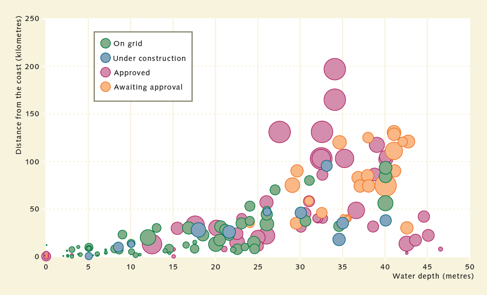
- 2.15 > So far the majority of the world’s wind farms have been constructed at distances of up to 40 kilometres from the coast and water depths up to 20 metres. In the meantime, offshore technology is so fully developed that installations can now be planned and built at far greater distances offshore. Proposed sites are located 120 kilometres offshore in extreme cases.

2.16 > Particularly on the west coast of Africa, as here in the Western Sahara but also in Morocco, sand is extracted on a large scale close to the coast. This is exported worldwide for use as building sand and for other purposes.
Valuable minerals
Another resource supplied by coasts are mineral raw materials, particularly sand and gravel which are used in concrete production, as filling sand on building sites, or for hydraulic filling to create new port or industrial sites on the coast. Well-known examples are the hydraulic fills that created land for the expansion of Hong Kong airport, the artificial Palm Islands off Dubai, or the new container terminal in Rotterdam, Europe’s largest port. Sand and gravel are either dredged from the sea floor using suction dredgers or extracted onshore – especially by demolishing dunes. Exact quantities are very difficult to estimate because data are not recorded centrally. Nonetheless, sand and gravel extraction and the export of both resources are considered to be a lucrative business.
For example, the island city-state of Singapore constantly consumes large quantities of sand in order to expand the city’s area by means of hydraulic filling. As a result of these activities, the area of the former British colony has expanded by a good 20 per cent since the 1950s. Singapore has much of the sand shipped in from very long distances. Many other countries also import sand. Sand from Australia is in particular demand because of its extremely hard, resilient and angular grains. On the one hand, this sand is good for concrete production because the grains adhere well to one another as the cement sets. On the other hand, the sand is used in industry as a blasting abrasive for sanding or smoothing other materials. According to data from the Australian Bureau of Statistics (ABS), Australia exports sand, gravel and stones valued at 5.5 to 8.5 million euros per month. It is extracted both from the coast and from inland sites.

Natural gold-panning effect
A more uncommon type of mineral resource are mineral placers: shallow deposits of metal or phosphorus compounds which form along coasts near to river estuaries. They come about through a kind of natural gold-panning effect: particles ranging from light to heavy are transported from the hinterland by flowing river water. In and around the estuary these are deposited in the shallow water off the coast. If the ocean swell is strong enough, the lighter particles are washed away while the heavier ones are buried more deeply in the sea floor. Over the course of millennia this process results in the formation of deposits several metres thick, which can be recovered by mining. Mineral placers can contain metals like iron, gold, platinum, tin or rare earth metals. At present, extraction is confined to especially valuable mineral placers only, such as those containing gold, platinum or diamonds. The latter are found along the coast of Namibia, where there is a strip just a few kilometres wide with a relatively shallow ocean depth of up to 150 metres. Ever since it was discovered in the late 1950s that large quantities of diamonds occurred in this part of the ocean, it has been the site of intensive offshore mining. Initially the sediments were only harvested by divers with large suction tubes. Currently extraction is taking place at depths of 90 down to 150 metres on an industrial scale using special ships. The area was divided up into several concessions in which different consortiums of firms operate. Today some two-thirds of all Namibian diamonds are obtained from the sea.
The fact that the sea floor off Namibia happens to be so rich in diamonds is thanks to the Orange River. The frontier river between Namibia and South Africa washed the gemstones from their region of origin, South Africa’s volcanic areas, into the sea. Over time, sea currents transported the sediment containing the diamonds northwards from the Namibian coast, where they concentrated in the sea floor as a result of the gold-panning effect.
Currently it is under discussion whether the mineral placers here containing phosphate compounds should also be extracted in future. These would be sold as fertilizers. Because the sea level has risen by around 130 metres since the last Ice Age, today these phosphate deposits lie deep below the waterline.
Resources from hydrothermal vents
Another type of valuable minerals that are likely to be recovered from the sea in future are the massive sulphides. These are found around hydrothermal vents on the sea floor, either at active undersea volcanoes or at plate boundaries where two continental plates are diverging.
Massive sulphides originate when cold seawater penetrates through fissures several kilometres deep in the sea floor. Around magma chambers at this depth, the water heats to temperatures of more than 400 degrees Celsius and dissolves sulphides, i.e. sulphur compounds, as well as minerals containing metals from the surrounding rock. Because it has been heated the mineralized water rises very quickly and shoots back into the sea. As soon as it mixes with the cold seawater, the minerals form a precipitate that settles around the plume in the form of massive ore deposits.
Normally the active volcanic sites are in the middle of the oceans and far from land. One exception is the Bismarck Sea off New Guinea, where a plate boundary is found just 30 kilometres from the coast. Known as the Solwara-1 field, its deposits are easily accessible by ship and contain copper, zinc, lead, gold and silver as well as numerous important trace metals like indium, germanium, tellurium and selenium. But despite the proximity to the coast, the water depth is around 1600 metres because the sea floor drops away steeply at this point. The Canadian mining company Nautilus Minerals has long been planning the extraction of the valuable ore deposits and has already had heavy underwater mining machinery built. In addition, a production ship is currently under construction. So far the commencement of mining activities has been repeatedly postponed because the financing of the project was not adequately secured or no agreement could be reached between Nautilus Minerals and the Papua New Guinea authorities. When the mining of massive sulphides might begin therefore remains to be seen.
Extra Info The Palm – artificial islands alter a whole coast
Areas for growing coastal cities
The availability of areas for particular uses can also be understood in a broader sense as an ecosystem service provided by coastal waters. This includes areas used for military training and for pipelines, residential complexes, port and industrial facilities, hotels and wind farms. Due to the growing population in coastal regions, land use along the coasts will increase, as new projections by a German-English team of researchers show. On the basis of various global population growth scenarios the scientists estimated how large the coastal population will be in the years 2030 and 2060. The study applied to the coastal strip located a maximum of 10 metres above sea level, which is known as the Low Elevation Coastal Zone (LECZ). This is especially under threat from sea-level rise, and is therefore of great interest. In the most extreme scenario assumed by the researchers, the global population will have grown to 11.3 billion people by the year 2060. In that scenario, up to 12 per cent of the global population will be living in the LECZ: around 1.4 billion people. For comparison: in the year 2000 it was inhabited by some 625 million people. The study predicts that megacities close to the coasts will grow proportionately.
According to this study, the most drastic population increases will occur along the coasts of Bangladesh, China, India, Indonesia and Nigeria. It is also expected that cities such as the Angolan capital, Luanda, Madras in India and the Chinese city of Tianjin will turn into megacities of far in excess of 8 million inhabitants.
- 2.18 > Global population growth means that low-lying coastal areas, especially in Africa and Asia, will be increasingly densely settled in future.


- Future population growth will not be the only reason for greater land consumption along the coasts. There is demand for new land even today for growing international trade – particularly for the enlargement of container ports such as Rotterdam. A start was made in 2008 with reclaiming an area of around 2000 hectares to form a site for what is now the Maasvlakte 2 container terminal. Surrounded by a foredike 12 kilometres long, it protrudes like a nose into the North Sea, i.e. into deep water. In contrast to many shallower parts of the port, even the largest container ships in current use with a capacity of 19,000 containers and a loaded draft of up to 20 metres can dock here.
The drastic expansion of offshore wind power in Great Britain and Germany is another factor that is changing the character of original marine landscapes. At these construction sites the sea floor of the North Sea normally consists of sandy sediments, and solid structures like rocks are seldom found. Now, to accommodate the hundreds of wind turbines, increasing numbers of solid structures – also referred to as hard substrates – are being created. These can increasingly be colonized by species that require a hard substrate – for example, sea anemones, various snail species and calcareous tubeworms. How this will change the species composition in the North Sea is a current subject of research.
Since shipping and the operation of fishery vehicles are prohibited in the vicinity of windfarms for safety reasons, it is possible that these areas might also contribute to the recovery of sea-floor biotic communities that have been adversely affected by years of fishery
Extra Info The Strait of Malacca – a historical shipping metropolis
The highways of global trade
The transportation routes afforded by coastal waters are one of the provisioning ecosystem services that are taken for granted. Land-based transportation entails the great expense of constructing infrastructure in the form of canals, rails or roads. By contrast, coastal waters essentially provide waterways that are almost entirely cost-free. Today around 90 per cent of all goods worldwide are transported by ship – a total of almost 10 billion tonnes of goods per year according to the latest data from the United Nations Conference on Trade and Development (UNCTAD). The lion’s share is made up of crude oil, containerized goods, and what are known as “minor bulk” cargoes such as steel, cement or sugar.
- 2.22 > Ships are the most important means of cargo transportation. Every year they move almost 10 billion tonnes of goods around the world.


 2.23 > The most important goods transported by ship are crude oil, containerized goods and minor bulk goods like steel, cement or sugar.
- The most significant shipping routes today are those between South East Asia and Europe and between South East Asia and America. Particularly container freighters operate a regular schedule of crossings between the continents nowadays. Freighters often cover extremely long routes non-stop and in most cases offload their cargoes at large central ports which act as hubs for onward distribution. A share of the containers are transferred to the mainland transport networks and transported by truck or rail into the country’s interior. Another share of the containers are taken to smaller ports by smaller ships known as feeder ships.
From the container terminal in the port of Hamburg, some 40 per cent of containers are transported onward by heavy goods vehicle. 30 per cent are transshipped onto feeder ships and 30 per cent are transported inland on rail freight wagons. A noteworthy aspect is that in many cases, transportation inland remains in the hands of the terminal operators on the coast, meaning that the influence of the coastal hubs reaches far into the hinterland. From the seaport of Hamburg, for example, onward connections extend as far as Eastern and South Eastern Europe. One large terminal operator in Hamburg even maintains its own railway company which transports containers to its own terminals elsewhere, in Slovakia for example, in order to supply goods to the markets there and in neighbouring countries.

- CULTURAL ECOSYSTEM SERVICES –
COASTS OFFER RECREATION AND FORGE IDENTITY
The value of coastal aesthetics
In aesthetic and cutural terms, too, the world’s coasts play a special role. Moreover, they have religious and spiritual value for many people.
By way of an example, the significance of this ecosystem service is reflected in the traditions of the islanders of the Torres Strait, the relatively shallow seaway some 185 kilometres wide between Australia and the island of New Guinea. Within the strait are around 270 islands surrounded by extensive coral reefs, parts of which fall dry during the tidal cycle. Hence the transition from land to open sea is not abrupt but relatively gentle, over an area of many square kilometres. Therefore the language of the indigenous inhabitants does not have distinct concepts for “land” and “sea”; they refer to their environment as “sea country” or “saltwater country”. Traditionally they conceive of the islands, coral reefs and open sea as a kind of continuum without strict boundaries. Their sense of identity is bound up with the coastal habitat in its totality.
- 2.24 > Wyer Island which is fringed with a coral reef is situated in the seaway between Australia and the island of New Guinea, the Torres Strait. The indigenous inhabitants refer to this marine landscape as "saltwater country", a concept encompassing both the dry land of the islands and the ocean with its coral reefs.


 2.25 > The town of Positano on Italy’s Amalfi Coast illustrates the attraction that the coasts exert on people. They are aesthetic areas which offer cultural and spiritual enrichment and recreation.
- In past centuries the ocean has increasingly become a landscape that people yearn for and a destination for coastal tourists. Tour operators entice customers with images of palm beaches and blue water. Although comprehensive global data on coastal tourism does not exist, its huge economic importance is undeniable in the view of the United Nations Environment Programme (UNEP). It sees coastal tourism as based on a unique combination of factors resulting from the conjunction of land and sea. Among these are the intense sunlight that frequently prevails, the recreational value of the water and its numerous opportunities for sporting activities, panoramic views and a vast biological diversity of birds, fish and coral species.
According to data from the World Tourism Organization (UNWTO), the global added value of tourism is immense, accounting for a 7-per-cent share of all worldwide exports of goods and services. In 2015 alone, it generated income amounting to 1.26 trillion US dollars. Whereas the number of tourists travelling internationally was put at just 25 million in 1950, by 2015 the figure had reached almost 1.2 billion worldwide.
Measured in terms of numbers of tourists entering the country, the global rankings of the most popular countries for holidays are headed by nations with highly developed coastal tourism. Four of the top ten travel destinations are countries bordering the Mediterranean, led by France with 84.5 million foreign visitors, although it should be borne in mind that the French holiday destinations also include inland locations like Paris or the châteaux of the Loire Valley. In second place is the USA with 77.5 million visitors. Spain is placed third with 68.2 million and China fourth with 56.9 million holidaymakers from abroad. Narrowing the perspective solely to international travel within Europe, Spain actually achieves first place, being the destination for a good 20 per cent of all foreign travel by Europeans within Europe.

- 2.26 > The importance of coastal regions for tourism can be seen from the list of the ten most popular travel destinations. Four of these countries with well-developed tourism sectors are on the Mediterranean alone.


- Highly developed coastal tourism also has its downsides, however. In many locations, the construction of hotel complexes has resulted in the loss of natural areas. Moreover, the wastewater and waste from tourism centres have polluted coastal waters, while coral reefs have been severely degraded by heavy use for tourism. Original, unspoiled coastal landscapes are ever more seldom found; a state of affairs that is criticized by many. Ultimately it can be said that the uniqueness, beauty and special aesthetic quality of the coasts is an ecosystem service in its own right.
Even more of a good thing
Coastal areas in their entirety provide numerous other ecosystem services, although it is not always possible to differentiate strictly between coastal waters and the open sea. The ocean absorbs large quantities of carbon dioxide, thus regulating the climate and having a very significant effect on the global climate system. What share of this is attributable to coastal waters alone is impossible to quantify with certainty. Nevertheless, it is evident that they are under particular threat since they are far more severely exposed than more remote ocean regions to human-induced negative impacts.