The myriad faces of the coasts
A million kilometres of coasts
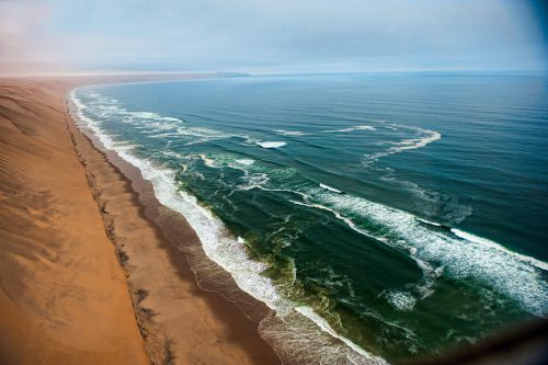
The coasts of the world are highly diverse. The northern coast of Brittany in France is characterized by granite cliffs interspersed with numerous bays. In Namibia the high dunes of the Namib Desert extend to the Atlantic shore, where the coast runs nearly parallel to the dunes. In Siberia, by contrast, the flat coastal region is dominated by permafrost, a metres-thick layer of frozen soil whose surface thaws out for a few weeks each year during the short Arctic summer, when it is especially susceptible to wave action. During storm-flood events, several metres of the saturated banks can break off, creating a constantly changing shore face.
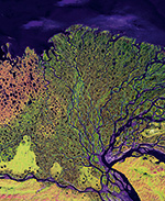
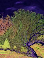 1.19 > This satellite photo shows the Lena River delta in Siberia with all its fine structures, extending around 150 kilometres into the Laptev Sea. A large proportion of the sea ice that eventually drifts out into the Arctic Ocean originates in this marine region.
- What all of these coasts have in common is that they are narrow strips of land exposed to the forces of the sea. Depending on the context they can be classified in different ways. Coasts can be distinguished based on whether they are strongly or weakly washed by the surf and currents. They can, alternatively, be classified according to the materials they comprise or by the rate that the material is eroded away by the sea. Coasts can furthermore be characterized by their ability to capture sediments that are delivered by rivers or currents. The ultimate form exhibited by a coast also depends significantly on the interplay between the materials that make up the substrate or that rivers transport to the coast, and the physical forces of wind and wave action that impact those materials.
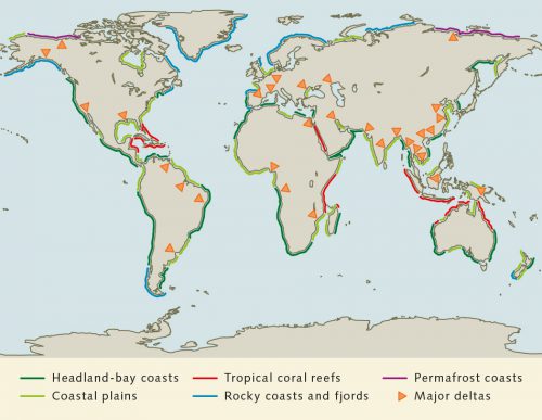
Geologists estimate the total global length of coastline to be around one million kilometres. This projection, of course, depends on how fine a scale is applied. When considering the entire globe, any differentiation of the coasts is only practical at a relatively coarse scale. For this categorization the continental margins can be traced in their present forms, which are in part a result of plate tectonics. Researchers created such a classification system in the 1970s, under which six different categories of coasts were distinguished.- Coastal plain: an area where the land gently flattens toward the sea. An example is the coast of the West African country of Mauritania, where the land merges into the sea through a broad strip of coastal marshes and low dunes.
- Major delta: a large river mouth where sediments from the river are deposited because the ocean currents or tides are not strong enough to transport the material away. This is the case with the delta of the Lena River in Russia, which flows into the Laptev Sea in the Arctic Ocean.
- Tropical coral reef: a structure composed of carbonate produced by sessile corals (Cnidarians). It develops as a fringe along the coasts in near-surface waters penetrated by abundant light. Reef-building corals occur in tropical and subtropical waters at temperatures consistently greater than 20 degrees Celsius. A spectacular tropical coral reef is situated along the Central American Caribbean coast between Honduras and Belize. It is around 250 kilometres long and is among the most popular diving areas in the world.
- Rocky coast and fjord: a coast of solid rock. Fjords, like those found abundantly on the west coast of Norway, represent a special kind of rocky coast. They were formed during glacial periods, when the motion of the glaciers scoured deep valleys into the bedrock.
- Permafrost coast: a deeply frozen soil covering large areas of the Arctic land masses in the northern hemisphere since the last glacial period. Permafrost is found over many thousands of kilometres along the coasts of North America, Siberia and Scandinavia.
- Headland-bay coast: a coast where rocky headlands extend into the sea. The headlands act as barriers to obstruct the surf and currents. Slow eddy currents form in the sheltered areas between headlands, gradually eroding the shore and forming bays. An example of this is Half Moon Bay on the Pacific Coast of the United States near San Francisco. There, over thousands of years, a half-moon shaped bay has formed behind a prominent headland.
Wind and waves shape the coasts
The physical forces of the sea – the waves, currents and winds – have a substantial effect on the shape of the coasts. The intensity of these forces is used to distinguish between low-energy and high-energy coasts.
The kind of material that makes up the substrate of a coastal area is also a key factor influencing the formation of the coasts. Tidal flats comprising relatively fine sediments can be reworked fairly quickly because these materials are easily transported by the currents. Fine sands can also be easily transported, as illustrated by the East Frisian Islands off the German North Sea coast. Because the prevailing winds there blow from the west, wave action carries sand away from the northwest side of the islands and redeposits it on the east side. In the past this has caused the islands to slowly migrate eastward. To impede this motion, rock jetties and breakwaters were built as early as the 19th century to fortify the islands. This greatly helped in preventing further migration.
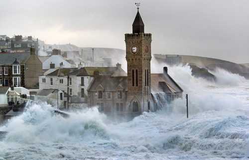
- 1.22 > The village of Porthleven in the English county of Cornwall is located on an extremely high-energy rocky coast. Accordingly, the shoreline fortifications, including massive walls, are very substantial. Under conditions of very high seas, however, they are hardly noticeable.
-
The intertidal zone
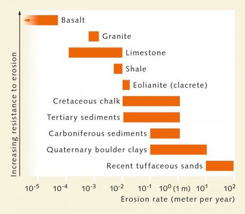
The intertidal zone is the area of the coast that is flooded and then exposed again by the rhythm of daily tidal cycles. The surface can be mudflats, sandy beaches or rocky cliffs. Rocky shores are exceptional because they occur on steep coastlines, while most other intertidal zones are found on flat coasts. Large-scale flat intertidal areas which include the salt marshes on the shore are called mudflats. - While changes in the shape of sandy coasts are often visible with the naked eye, they can be more difficult to recognize when other material is involved. But even high-energy rocky coasts do change their appearance over time. The rate of change, however, depends largely on the properties of the rocks. Coasts composed of compacted but not yet lithified ash, generated over time by ash falls from volcanic eruptions, are especially easily eroded. Examples of this kind of coast are found in New Zealand. Up to ten metres of coast can be lost there within a single year at some locations. Chalk cliffs, like the White Cliffs of Dover in the extreme southeast of England are also relatively soft. When exposed to strong currents they can be eroded by several centimetres per year. By contrast, hard granitic rock is depleted at most by only a few millimetres in the same space of time. Harder still, black volcanic basalt is only destroyed by water each year by a maximum of a few hundred billionths of a metre.
- 1.23 > Depending on the material making up the coasts, they can be eroded slowly or more rapidly. Some can be depleted by several metres in a single year.
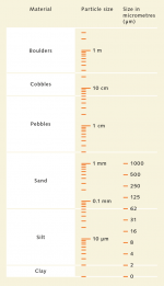
- 1.24 > The materials that make up the coasts are classified according to the size of the particles they are composed of. This scale extends from microscopically small clay particles to large boulders.
A question of particle size
Understanding the nature of the substrate in coastal areas is especially crucial for coastal protection, coastal management, and the planning of waterways and port installations. In particular, the size and density of the particles that make up the material play an important role. These can be factors, for example, in determining whether the shore of a populated island is in danger of erosion or whether shipping channels might shift their positions causing ships to run aground. With respect to the size of particles, the following coastal types are differentiated:- muddy coasts,
- sandy coasts,
- pebble coasts,
- cobble coasts,
- rocky or boulder coasts.
The filtering function of the coasts
In many areas the character of the coasts is strongly shaped by rivers – through both their current strength and the material loads that they transport. They carry many minerals and nutrients that are incorporated to some extent into the sediments. Coasts that are rich in such sediments are also highly productive. A good example are the Sundarbans in Bangladesh and India, which, with a total area of around 10,000 square kilometres, comprise the largest block of mangrove forest in the world. The Sundarbans formed in the estuarine areas of the Ganges and Brahmaputra Rivers, which deliver immense amounts of material into the Gulf of Bengal. The Sundarbans are a vital unspoiled natural region. They are home to abundant birds, fish, crocodiles, pythons, deer and wild boar. Furthermore, rare animals such as the axis deer and Bengal tiger may also find refuge here.
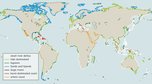
Depending on the ability of a particular coast to filter and store the material transported by rivers, it can be designated as having an active or inactive filtering function.
Coasts with an active filtering function
- Delta: A river mouth that gradually grows outward into the sea due to the deposition of sediments is called a delta. The ocean currents or tides are not strong enough to carry the material away. Deltas can take on different forms. Ultimately they are shaped by the interacting forces of waves, river currents and tides. Depending on which of these forces is predominant, different types of deltas are created, which are then categorized as tide-dominated, fluvial-dominated and wave-dominated deltas.
- Because of the constant cycle of advancing and receding tidal currents, sediments in a tide-dominated delta form long sand banks perpendicular to the coast. The surf here is comparatively weak. The combined mouth of the Ganges and Brahmaputra Rivers in India is an example of this kind of delta.
- The influence of waves is also relatively minor in a fluvial-dominated delta. Furthermore, the tidal range, the vertical difference between low- and high-tide levels, is at most two metres, which produces a relatively weak tidal flow. A large amount of sediment can thus be deposited at the river mouth. Over time, this kind of river delta can become choked by sand. The river is then diverted to a new channel, creates new beds and bifurcates repeatedly to form a bird’s foot delta.
- Over time, in the wave-dominated form, the surf pushes the sediment into mouth bars, beaches and sand bodies orientated parallel to the shore. Neither the river nor the tides are strong enough to carry these mouth bars away. An example of this can be seen in the Danube Delta in the Black Sea.
- Delta: A river mouth that gradually grows outward into the sea due to the deposition of sediments is called a delta. The ocean currents or tides are not strong enough to carry the material away. Deltas can take on different forms. Ultimately they are shaped by the interacting forces of waves, river currents and tides. Depending on which of these forces is predominant, different types of deltas are created, which are then categorized as tide-dominated, fluvial-dominated and wave-dominated deltas.
- 1.26 > River deltas can be formed in different ways. Their shapes are ultimately determined by the interplay of the forces of tides, waves and river currents.

- Tide-dominated estuary: In contrast to the delta, a tide-dominated estuary refers to a single large river estuary that is shaped by the tides. This usually has a funnel-shaped mouth that extends far inland, following old river valleys formed during the glacial period, as in northern Europe, for example. During high tide the river water is piled up into these funnels. At low tide the backed-up water then flows rapidly into the sea, washing a load of sediment out with it, so a delta cannot form within the estuary. Instead, large-scale tidal flats may be created on both sides of the funnel, such as those seen near the mouth of the Elbe River in Germany. The Elbe can thus be considered a typical tide-dominated estuary.
- Lagoon: Lagoons are characterized by relatively shallow coastal waters with a maximum depth of five metres. As a rule they are separated from the open ocean by barriers. These can be sandbanks, coral reefs, or offshore islands. Lagoons are usually elongate and orientated parallel to the coast. This is the case for those in the Baltic Sea, which are separated from the sea by elongated dunes, such as the Vistula Lagoon. In lagoons the interaction between the sediments and water is especially pronounced. Because wave and current action are virtually absent in lagoons, the water is relatively quiet. There is thus more time for suspended material to sink and be deposited. Lagoons often have narrow openings to the sea so that salt water and seawater mix to create brackish water. Chemical reactions can occur in this mixing area that result in a fine precipitation of flocculated material, which is then deposited in the sediment.
- Fjord:Generally, fjords are valleys that were formed by glaciers. These often very steep and deep valleys were flooded with the rise of sea level. Many fjords are closed off from the sea by coarse debris. This commonly consists of a deposit called moraine that was piled up by glaciers. The German term, “Förde”, refers to a feature similar to a fjord that is also formed by glaciers, but is generally wider, shallower and more branching. Because no large rivers flow into the fjords as a rule, the currents are weak and material can also be deposited here.
Coasts with an inactive filtering function
- Coasts with rapidly flowing rivers: In many cases large rivers flow with such a high velocity that, even though they carry a heavy load of sediment, the material is not deposited near the coast but carried out to sea in a kind of suspended cloud. To the extent that this occurs, the filtering effect of the river mouth is limited. An example of this is seen in the Columbia River in North America.
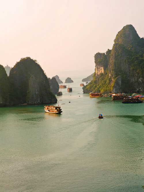
- Karst-dominated coasts: This kind of coast consists primarily of limestone. It was formed over millions of years from the carbonate shells and carapaces of marine organisms. Plate tectonic forces lifted these chalk masses up out of the sea, where they then consolidated and hardened over time to limestone. As a result of chemical weathering caves and passages are typically formed within the limestones, and rain and river waters flow underground through these into the sea. Karst landscapes form and rivers carve deeply into the rock. In some locations the karst landscapes have been flooded by rising sea level since the last glacial period. One example of this is the world famous Ha Long Bay in Vietnam, which was originally a river and karst landscape, but was later flooded by the rising sea level. Today, former cliffs on the river banks project out of the water as islands. Karst-dominated coasts are characterized by a paucity of sediment deposition due to their typical craggy structure and wave action.
- Arheic coasts: The coasts in very arid regions and deserts where precipitation is so low that no water at all flows into the ocean are called arheic coasts. The name derives from the geological term for rivers whose waters seep into the ground in a desert or salt flat before they can reach an ocean. These rivers are called arheic.
- 1.27 > The karst cliffs in the Ha Long Bay in Vietnam are world famous. Tourists ride on boats through the archipelago.
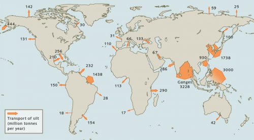
- The amount of sediment transported into coastal waters annually is immense. The material basically originates as a weathering product of rocks on the land. It is eroded by rainwater either directly from mountainous regions or washed out of the soils in the flatlands. Over millennia the landscape is gradually flattened. The leading transporter of material is the Ganges River, which carries 3.2 billion tonnes annually into the ocean. It transports mostly silt particles from the central Asian highlands that are dislodged from the substrate by physical weathering. The same process occurs in the Yellow River in China, whose distinctive colour is derived from a particular type of silt particles.
Degradation and accretion
Depending on local conditions coasts can grow or shrink. While some coasts increase in volume with sediment deposition, others are eroded over time due to current or wave action, as evidenced on the Norfolk coast of England. The village of Happisburgh here, with a popu-lation of about 1400 living in 600 houses, has achieved a sad measure of fame as a result of its location.
- 1.28 > Coasts can also be differentiated based on how strongly they filter sediments that are delivered by rivers from the inland.
- At the end of the 19th century Happisburgh was located several hundred metres from the coast. Because of perpetual erosion of the coast, the village now stands directly on the edge of a ten-metre high cliff at the coastal margin. It continues to break off due to its composition of a soft mix of clay, silt and sand. Large pieces break off when strong east winds pound heavy waves against the coast. A number of houses have already fallen into the sea. Within the next decade Happisburgh could lose its Norman church, its lighthouse and a 14th century manor house to the sea. Attempts were made to counteract the erosional forces by constructing breakwaters, but these have proved ineffective. It is thus only a matter of time before Happisburgh falls completely into the North Sea.
- 1.29 > The sediment loads that rivers carry to the sea can be enormous. The world record is held by the Ganges River in Asia with a load of 3.2 billion tonnes annually.
- Accretion or degradation of a coast depends on various factors. A more detailed classification of constructive and destructive processes follows, whereby different time scales must be taken into account:
Destructive processes
- Endogenous erosion: destruction induced by the coasts themselves. This includes cliff slump and cracks (faults) resulting from earthquakes, or the collapse of volcanic islands, for example, when old craters cave in.
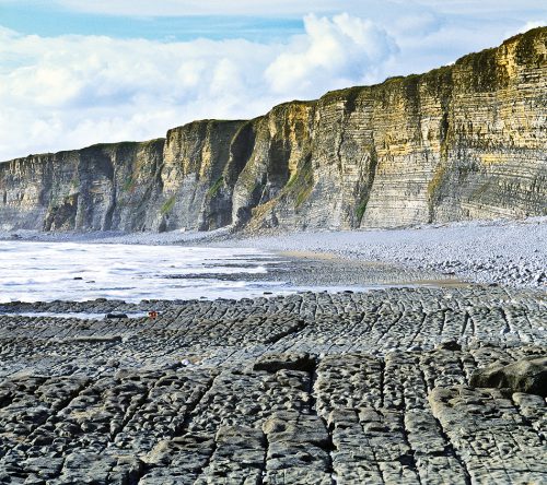
- Mechanical erosion: abrasion produced by wave action and drifting ice. This can generate many different coastal forms. Cliffs are one example, steep walls of rock that are by no means immutable, for even hard rocks are eroded over time. Cliffs begin to form when waves undercut the rocks at the base of a steep wall. The wall thus becomes unstable and breaks off, forming the typical high cliffs. Another coastal form caused by abrasion is the flat coast. This is characterized by a broad area in the littoral zone sloping gently seaward. Depending on the material, these can be categorized as sand, pebble, or rocky shores. On sandy beaches the shore is the gently sloping, wet part of the beach that is shaped by the forces of water. Seaward of rocky cliffs a flat wave-cut shore is found. These are recognizable by parallel deep ridges in the rock that are created when the bedrock is composed of different individual rock layers. Because the different materials are eroded at different rates by the energy of the surf, deeper and shallower areas result, creating a profile of ridges defined by the boundaries of the rock layers. Erosion can also wear away coasts in other ways. An example is the undercut cliff. These begin as notches in rocky coasts at the level of the water line caused by wave action.
- Scouring of the coastline: destruction that occurs on frozen coasts such as those with permafrost or glaciers. In the permafrost regions of the northern hemisphere summer thawing leads to softening of the soil that was frozen during the winter, making it more susceptible to erosion by the waves. This kind of destruction, called thermoabrasion, changes the coastline. In the Arctic and Antarctic, the coastline changes primarily due to the breaking off of large fragments of glaciers. Because of their massive weight, continental glaciers slide slowly from the land into the sea where they can sometimes project several kilometres out into the water as shelf ice. Because the ice is less dense than water, the glaciers float on the sea surface in spite of their great weight. Large chunks break off continually because the glacial mass is being pushed from the land out into the sea. This is called glacier calving.
- Bioerosion: destruction of hard substrates by microorganisms that slowly break down the rocks through their metabolism. This occurs, for example, in undercut cliffs.
- 1.30 > On the southern coast of Wales, near the city of Cardiff, abrasion has cut a flat shore into the limestone.
Constructive processes
- Endogenous build-up: the formation of new coastal areas due to plate tectonic processes whereby land masses are uplifted. These include volcanic eruptions that through time release sufficient magma from the Earth’s interior to create islands. In other cases new coastal segments are created when large amounts of lava from a volcanic eruption flow into the sea.
- Potamogenic origin:formation of deltas, tidal flats or wetlands by material imported by rivers.
- Formation by ice: accretion produced by coastal or pack ice shoving material together. The driving forces are provided by waves or tides pushing ice toward the coasts.
- Formation by wind: build-up of coastal dunes from loose sand that is piled up by wind.
- Thalassogenic origin: formation by materials that are deposited on a coast by waves, tidal currents or ocean currents.
- Biogenic origin: construction of coasts by living organisms. These include corals, which build solid and durable structures, or mangroves, which can abruptly curb the wave and current energy so that fine particles are deposited and tidal flats are formed. Not only do organisms contribute to the construction of coasts, however, but also to their protection. Corals and mangroves are natural breakwaters. Kelp forests can also absorb large amounts of wave energy. Furthermore, these plants also consolidate the sediments so that they cannot be washed away again by strong currents. Salt marshes also act as natural current barriers to protect the inland regions.
- The extent to which these natural formation processes act is very well illustrated by the deltas of large rivers. Over time, the Mississippi River has transported so much material that the delta has grown to a width of around 200 kilometres. The weight of the sediments is so great that the delta is continuously subsiding. In addition, water is being squeezed out of the sediment, which represents a kind of compaction. In geological terms, compaction refers to the compression and decrease in volume of sediments, due in part to the pressure created by overlying sediment layers. The subsidence was formerly compensated by fresh material being constantly transported in. Human activity, how-ever, has disturbed this compensatory process. Dams have been constructed along the river, trapping large volumes of material before they can reach the delta. Sediment replenishment at the coast has been thus cut off. But because the delta continues to subside under the weight of the old sediment packages, humankind is now exposed to the problem of a significant increase in the frequency of floods.

