How nature and humankind alter the coasts
Importance and characteristics of coastal zones
The coast is the interface between the land, ocean and atmosphere.The coast is the interface between the land, ocean and atmosphere.There is no standard definition of what constitutes “the coast” because it depends largely on one’s perspective or the scientific question – the coastal zone can be considered more the sea, or more the land. Simply stated, the coastal zone encompasses that area where the land is significantly influenced by the sea, and the sea is notably influenced by the land. This is a complex space that is also strongly impacted by human activ- ity. The coastal zones of the Earth are extremely diverse and tremendously important, not only for humankind.Further information on this topic is available here:- They cover around 20 per cent of the Earth’s surface;
- They are the site of vital transport routesthe site of vital transport routesand industrial facilities;Further information on this topic is available here:
- They are prime recreation and tourist areas;prime recreation and tourist areas;Further information on this topic is available here:
- They are a resource for mineralsa resource for mineralsand geological products;Further information on this topic is available here:
- They contain important ecosystems with large species diversity;
- They function as an important sediment trap that consolidates sediments from the rivers;an important sediment trap that consolidates sediments from the rivers;Further information on this topic is available here:
- They influence many global parameters in their role as a buffer between the land and sea;
- 75 per cent of the mega-cities with populations over ten million are located in coastal zones;mega-cities with populations over ten million are located in coastal zones;Further information on this topic is available here:
- 90 per cent of the global fishery activity occurs in coastal waters;global fishery activity occurs in coastal waters;Further information on this topic is available here:
- They are the place where more than 45 per cent of the world’s population lives and works.
Sediments shape the coasts
The shape of a coastThe shape of a coastis influenced by many factors. One important factor is the shifting of sediments, such as mud, sand and gravel. The sediments are primarily transported by wind-induced waves and water currents – either tidal currents, or rivers that flow into the sea. Depending on the currents, sediments are either eroded, redistributed or deposited (accumulation). If sediments are carried away instead of being redeposited, the shape of the coast will change over time. One example of this is the East Frisian island Memmert, where currents caused so much erosion on the southwest side that the old lighthouse was standing in water until it was finally demolished. Another example is seen on the western beach of the Danish North Sea island Rømø. It is continually growing wider due to sediment input.Further information on this topic is available here:
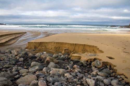
- 3.6 > Tidal currents on the coast of the Isle of Lewis, off the west coast of Scotland, have carried away the sand and left the stony ground exposed.
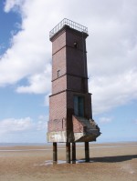 3.7 > The old lighthouse on the East Frisian island of Memmert once stood in the dunes, but was washed out by erosion over the course of decades.
- In principle, there are two main directions of sediment transport. One of these is parallel to, or along the coast. The other direction is either toward or away from the coast. The more sediment that is eroded or deposited, the more strongly the coastal form changes. The rate at which sediment can be eroded depends on its composition, as well as on the intensity and persistence of the wind and water currents. A strong storm tide can wash away immense amounts of sediment within a few hours. On hard, rocky coasts, which are more resistant to erosion than loosely deposited sand, the shape of the coastline changes comparatively slowly. A coast usually recedes as a result of erosion: More sediment is lost than is replaced by the currents. The developmental status of a coast, however, is not defined by its sediment balance alone. There are coastal areas that are stable over the long term because sediment is simply transported along them. In many coastal regions today, the natural input of sediments is hampered by construction projects such as dams. Only 20 per cent of the coastal regions worldwide are made up of loose materials such as sand, mud or gravel, but more than half of these coasts are suffering from erosion today. Of course, the loose-material coasts generally adapt quickly to changes because the sediments are redistributed relatively easily – material deficits at one place are balanced again by new sediment input. Yet whether the character of such a coast is preserved in individual cases is essentially dependent on the rate of sea-level rise, stability of the sediment, and sediment input. Even coastal protection measures do not only contribute to the preservation of the coasts. They can also alter the coasts. It is even very possible that by attempting to protect one segment of a coastline, another area is damaged. When one area is protected from erosion by construction of a breakwater, an adjacent, non-protected area may be deprived of its essential sediment input. Compared to sandy coasts, sea-level rise will have a less severe impact on steep and especially rocky coasts. Worldwide, steep and rocky coastlines make up about 80 per cent of all coasts.
Sediments cause the Earth’s crust to sink
It is clear that coastal areas subside under the weight of the glacial masses placed there in ice ages. But sediments can also accumulate in such thick layers that they press down on the lithosphere, the Earth’s crust. This subsides initially and then rises again later when the load is removed. In the case of glaciers, this happens when the ice melts at the end of an ice age. The rebound movement can last for several tens of thousands of years. An example of this can be seen on the Scandinavian land mass, which is still rising today by up to 9 millimetres a year. Sometimes the Earth’s crust rebounds unevenly, so that one part is still sinking while another is rising.
Thick sediment packages are often deposited in delta regions where the rivers transport enormous quantities of sediment to the sea. Because of the stacking of sediments, the lithosphere gradually yields to the pressure. The subsiding bedrock thus produces a rise in sea level relative to the land. In some cases this isostatic subsidence is compensated by the gradual upward increase in sediment thickness. In other cases, however, the sediment itself is compressed by the increasing load so that the land mass still sinks.
Humans can also accelerate the subsidence, for instance by extracting groundwater, oil or natural gas, as in the Niger Delta. There are regions where the land surface is falling by up to 5 cm per year due to the combined effects of these factors. Relative sea level rises there accordingly.
Humans mould the face of the coasts
Over the past 8000 years, during the final phase of sea-level rise after the last ice age, sedimentation has contributed enormously to the development of the coasts. Coastal land areas grew by the deposition of transported material, and in some regions large river deltas were formed. Rivers are very important transport paths for carrying sediments to the coasts.Rivers are very important transport paths for carrying sediments to the coasts.The volume that they carry depends on several factors:Further information on this topic is available here:- The size of the catchment basin from the source to the estuary;
- The relief in the catchment basin (rivers in high-relief mountainous areas transport more sediment than rivers that flow through flatlands);
- The rock and sediment characteristics (for example, grain size) or the amount of available sediments from weathering and mechanical erosion;
- The climate in the catchment area and its impact on weathering;
- The amount of surface water flowing downstream and the storage capacity of the soil (how much water flows also depends on the amount of precipitation, which is, in turn, dependent on climate).
- By contrast, many regions are plagued by a paucity of sediments because the water is held back by dams.many regions are plagued by a paucity of sediments because the water is held back by dams.Worldwide over 41,000 large dams are in operation. There are also many smaller dams and water reservoirs. Together, they block 14 per cent of the total global river flow, as well as enormous volumes of sediment. This is a severe loss for the replenishment of the coasts. Erosion increases. This sediment deficit is fatal in places where the basement is subsiding beneath the old, heavy sediment packages. New sediment is lacking that would normally be deposited to compensate for the subsidence.Further information on this topic is available here:
If the land sinks, saltwater gradually intrudes into the estuary and adds salt to the groundwater. The Nile is a good example of this. Before construction of the Aswan Dam, recurrent annual floods washed fertile sediments from the interior of the continent into the Nile Delta on the Mediterranean Sea. Not only were the sediments essential for the farmers on the banks of the Nile, they were also crucial to compensating for subsidence in the heavy delta region. After the dam was built in the 1960s, the flooding and transport of sediments came to a halt. This resulted in sustained harvest reduction and massive coastal erosion. Similar problems can be expected in China’s Yangtze Delta because of the recently completed Three Gorges Dam.
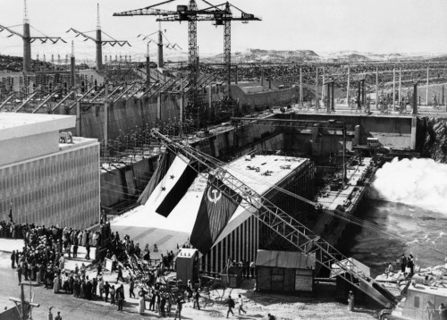
- 3.8 > With the beginning of operations in 1968, the Aswan Dam was celebrated as a masterpiece of technology. At that time nothing was known about environmental impacts such as land salination on the coasts. The dam was officially opened in 1971. Its construction took around eleven years.
- Recent investigations on the North American Atlantic coast, based on interpretations of satellite photos and topographical maps covering a period of over 100 years, suggest that rising sea level also disturbs important sedimentation processes and will lead to changes on the coasts. It is believed that a sea-level rise of 1 metre will result in an average retreat of the coastline by about 150 metres. This presumes, according to the researchers, that the sediment balance (erosion and deposition) is in a state of equilibrium. The examples cited here, however, clearly show that that is not the case. For the calculations, therefore, one would at least have to consider the sediment transport along the coasts and changes in the sedimentation balance that sea-level rise would cause. So far that has not been done. The coastal retreat could therefore be even more drastic.
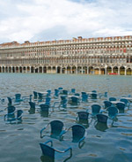
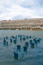 3.9 > At times of especially high water levels in the Lagoon of Venice some areas of the city, like the Piazza San Marco, are repeatedly flooded. Italians call the high water acqua alta.
Hydrologic engineering impacts
In many estuarine regions there is an alternating in- and outflow of seawater in phase with the tides, and thus a mixing of saline water with the fresh water continuously flowing out from the rivers. Suspended sediment from the land and sea can be deposited when the currentenergy level drops. The sediment budget is subject to a very sensitive balance. The building of dams, deepening of channels, or other construction can severely disturb this balance. The impacts are often very serious.
Among other activities, the deepening of channels is highly controversial today. 95 per cent of global commerce depends on shipping. For logistical reasons most of the world’s large harbours are located on river estuaries. The ever-increasing sizes of the ships used, with their corresponding deep draughts, require deeper channels. Additionally, the shipping routes are stabilized by structures on the banks, and current flow is optimized by control structures. The deepening of channels can release pollutants trapped in the sediments. In addition, the flow rates can increase, which also increases sediment redistribution.
Due to the larger volume of water flowing in and out, the tidal range can also increase. This further affects the sediment budget, because more rapidly flowing water has more energy for moving sediments. Sea-level rise and high-water events amplify these effects. There is already concern about how this impacts the structural integrity of the river dams. The high volume of ship traffic exacerbates the situation because the ships’ wakes often erode the river banks. The removal of sediment or sand,removal of sediment or sand,which is a common procedure on the island of Sylt for beach restoration, changes the shape of the sea floor. In the long term this can definitely have an impact on the protection of the coasts. It is possible that deepening the seafloor could shift the wave-break zone to a position closer to shore.Further information on this topic is available here:
The removal of large quantities of sand would also change the habitats of marine organisms. This is similarly the case in the reverse situation when sand is discharged into the sea, for instance when dredged material is dumped onto the sea floor. 80 to 90 per cent of these sediments originate from operations related to channel deepening. Hundreds of millions of cubic metres of sediment are dumped annually worldwide. If they are not able to escape, marine organisms living in the dumping areas are covered up.
- 3.10 > If the coasts were not protected by dikes, sea-level rise of 2 metres would produce this picture. The red-coloured areas would be permanently inundated. According to current predictions sea level could rise by as much as 180 cm by the end of this century.

Coastal city growth
Human societies also damage the biotic environment through the tremendous growth rates of coastal cities. New land areas are often created in the sea to make room for the overflowing development. Many large projects worldwide, including the airport in Hong Kong, have been built in this way. For that project an area of over 9 square kilometres was filled. The harbour at Tianjin in China was even larger, appropriating around 30 square kilometres of marine area. These encroachments have significant impacts on the directly adjacent coastal zones. For example, fill material covering 180 hectares used in construction of the Nice airport triggered a disastrous landslide in 1979. This then caused a tsunamitsunamithat took the lives of 23 people.Further information on this topic is available here:
Climate change alters the coasts
In order to accurately predict the future fate of coastal regions, researchers must first determine whether the present measurable changes are actually a consequence of climate change or an expression of natural climate variability. We can only speak of climate change if climate-related changes are statistically discernable from natural fluctuations. Climate change is thus not equivalent to climate variability. Scientists hence need to have measurements and observations covering representative time intervals.
We already know that global warming will not lead to uniform increases of air and water temperatures everywhere, and the change is not restricted to temperature changes. The consequences of climate change can be highly variable. This is clearly illustrated in the following examples.
Melting of sea ice and thawing of permafrost grounds
Sea ice in the sub-polar and polar coastal waters acts as a buffer between the atmosphere and seawater. It prevents storms from creating waves that would roll into the coasts and remove sediments. If the ice masses shrink by thawing, this buffering effect is lost. Sediments that were previously protected by the ice cover are also more strongly eroded. Permanently hard-frozen soils, called permafrost grounds, thaw out. These are also more easily eroded by wind and waves on the coasts than the frozen land masses. On the other hand, erosion typically caused by icebergs and glaciers no longer occurs.thawing of permafrost groundsFurther information on this topic is available here:
Changes in freshwater balance, precipitation and sediment input
Climate change will presumably lead to the melting of continental glaciers, while at the same time the amount of new snow required for maintaining the glaciers will probably decrease. Over time this will also lead to a decline in the amount of freshwater flowing from the mountains. Water shortages could result. People could respond by increasing the amount of water held in reservoirs. This, however, would result in less fresh water and sediments being transported to the ocean. At the same time, in other areas, increased precipitation is expected as a consequence of global warming, for example, in the monsoon regions of the world. The strong monsoon rains and water discharge will lead to increased flooding and the transport of large amounts of sediments and nutrients by rivers into the coastal seas.
High tide and spring tides Mean high tide refers to the average high-water level at a particular location on the coast. Flood tides that reach especially high above the mean high tide are referred to as spring tides. These occur regularly, corresponding to certain alignments of the sun and moon. It is particularly dangerous for the German North Sea coast when heavy storms from the west coincide with the spring tides.
Island and coastal flooding
The rise in sea level caused by climate change will lead to flooding in many coastal areas and island groups. It is expected that these regions will not be just temporarily, but permanently submerged. These floods thus cannot be equated with the short-term, episodic flooding of land areas that will occur more frequently in the near future. Sea-level rise could reach the two-metre mark as early as the next century or soon thereafter. This scenario, however, is based on topographic data alone. It does not take account of dikes and other protective structures. Simulations simply allow the water to flow over the coastal contours. This model also does not consider the increased removal of land by coastal erosion, which will probably accompany rising sea level. Complete coastlines, along with their surf zones, will likely shift landward due to the erosion. The destructive power of the water will then be unleashed on areas that were previously protected. Today, storm floods are already tearing out protective vegetation. These negative effects will only intensify in the future. The very gently rising coastal slopes, where the surf can gradually roll up to the land, are becoming steeper. The steeper coastal foreland presents a greater surface area of vulnerability for future storms to assault. Erosion gains dynamic momentum. The buffering capacity of the coastal foreland decreases. Threatened regions also include many areas that are presently protected by dikes. For dike structures on the North and Baltic Seas the crown height is designed to be 30 to 90 cm above the maximum storm event height, as a safety factor in consideration of future sea-level rise. This will not be sufficient, however, for a sea-level rise of 2 metres. Many densely settled areas in the North Sea area today already lie below the mean high-tide level, and in the Baltic Sea area at around the present-day sea level.
- Other coastal areas are characterized by complex and important ecosystems. These produce biomass that sometimes has a direct impact on the shape of the coast. For example, the growth of corals can create new islands. Coral banks are also important bulwarks that break the surf. In some cases the growth of corals can even compensate for the rise of sea level. Whether the formation of new corals will be able to keep up with the rise of sea level in the future depends on the rate of the rise as well as on water temperature. Researchers are concerned that living conditions for the adaptable but sensitive corals will become worse; firstly, because the water temperature in some areas is already too high today and, secondly, because the corals will not be able to keep up with the projected sea-level rise or possible subsidence of the coasts.
Other shallow coastal segments, such as estuarine areas, mangroves and marshes, which themselves provide natural protection against storm floods, are also threatened by flooding. In case the mangroves and marshes sink, waves can encroach onto the land and cause considerable damage. Only in very rare and uncommon cases could such changes be compensated by sediment input from inland.
- 3.11 > The storm surge of 1976 is notable as the most severe storm flood ever recorded on the German North Sea coast, and failure of the dike, as seen here on the Haseldorfer Marsh on the Elbe River, caused extremely severe damage. The water level in Cuxhaven reached a record high of 5.1 metres above normal. Nonetheless, the consequences were less severe than those of the flood of 1962 because many segments of the dike had been reinforced in the meantime.

Extreme water levels
It is now believed that extreme weather events such as tropical storms and storm surges will occur more frequently due to global warming. These will likely intensify the impacts of sea-level rise because when sea level is higher the destructive capacity of a storm on the coast is much greater. Scientists expect to see increased storm activity particularly in the temperate and tropical regions. There is still no consensus as to whether the frequency of storm activity will increase worldwide, because dif- ferent scientific computer models and measurement data have yielded different results.
- Storm floods originate through the interplay of storm systems and tides. When storm winds push the water toward the coasts during flood tide, especially during spring flood, the risk of flooding for large land areas is greatly increased. Such storms can last for several days and cause the water to rise so high that it does not abate even during the ebb tide.
Storms can also have severe effects in marginal seas such as the Baltic Sea, where the tidal ranges are minimal. Just like in a bathtub, the wind piles water masses up in one part of the basin, and when the wind abates or changes direction they slosh back. If the wind then blows in the opposite direction, the two factors can amplify the effect. As a consequence the water level on the German Baltic Sea coast can rise by more than 3 metres. Heavy precipitation can even intensify this situation because the rainwater or high water from the rivers cannot flow off due to the already high water level on the coast.
Increasing incidence of high water
There are other factors related to sea-level rise besides just increased water levels. It is of critical importance that unusually high storm-surge levels are occurring more often, as the example of the threat for Germany illustrates. With a sea-level rise of 1 metre, dangerous storm surges will occur more often because the base level is then a metre higher. In this case, a 100-year highwater level, like the storm flood of 1976 on the German North Sea coast, could take place every ten years. The probability of recurring severe storm surges would increase significantly. On the German Baltic Sea coast with its lower storm-flood levels, this effect would be even more pronounced. A 100-year high-water level with an elevation of 2.5 metres above mean sea level (German: Normalnull, NN) would occur every 2 to 5 years there.
