- Coastal dynamics
- > Coasts – the areas where land and sea meet and merge – have always been vital habitats for the human race. Their shape and appearance is in constant flux, changing quite naturally over periods of millions or even just hundreds of years. In some places coastal areas are lost, while in others new ones are formed. The categories applied to differentiate coasts depend on the perspective from which we regard them.

The shape of our coasts – a long and changing history
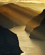
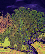
Coasts have a special significance for humankind. More than 90 per cent of global fishery is carried out in coastal waters. They are important transportation routes and significant sites for industrial and power plants. They are popular destinations for global tourism as well as a source of mineral and fossil resources. They are thus very attractive as working and living areas, which is evidenced by the fact that 75 per cent of all megacities with a population of more than 10 million are located in coastal areas. Coasts are generally viewed as a thin line where the land and sea meet. They are transitional areas that are constantly subjected to change that can take place at very different rates: over millions of years through continental drift, in phases of tens of thousands of years through the alternation of interglacial and glacial periods, and over recent centuries through their settlement by humans. Over relatively short periods of geological time, the fluctuations of sea level are primarily responsible for changes in the shape of the coasts. Because large amounts of water are sequestered in the form of ice and snow on the land during a glacial period, and the amount of water flowing from the land into the sea is diminished, sea level drops. Around 20,000 years ago, during the last glacial, sea level was about 120 metres lower than it is today. Many areas that are flooded today were dry at that time and the global area of land masses protruding from the water was about 20 million square kilometres greater than at present. Australia and the island of New Guinea were connected then by a land bridge and America was presumably being colonized by people from Asia over a land bridge across today’s Bering Strait. The formation of coasts in the northern hemisphere, however, was also strongly influenced by glacial ice. The Norwegian fjords, for example, originated when immense ice masses flowed from land into the sea and gouged out the bedrock. After the glaciers thawed and sea level rose, these grooves filled with water. Over millennia, the movement of glaciers and numerous other processes have been instrumental in creating a large number of coastal types: bare granite coasts like those in Scandinavia, permafrost coasts frozen several metres deep in Arctic regions and dense mangrove forests in tropical areas. Scientists organize this diversity into a range of categories. For instance, coasts can be classified according to whether their form is heavily or weakly influenced by wave action and currents. Coasts can also be categorized by the material that they are composed of, or by how strongly the material is eroded by the sea. They can be classified, furthermore, by how well they are able to trap sediments that are brought in by rivers or currents. This ability is referred to as the filtering function of the coasts. There are regions where large amounts of sediment are deposited on the coasts, such as the Mississippi Delta in the Gulf of Mexico. These coastal areas are often highly productive with abundant fish because the water receives a large volume of nutrients along with the sediments. The amounts washed into the sea by individual rivers are sometimes gigantic. The Ganges River, for example, carries an extremely large load of material from the Himalayas to the Gulf of Bengal – around 3.2 billion tonnes annually. In many cases people have intervened in the natural sedimentation processes through various kinds of construction projects. The resulting changes have caused problems in many locations.

