![© [M], Bryan & Cherry Alexander/Arcticphoto/laif](https://worldoceanreview.com/wp-content/images/wor1/kapitel_01b_k.jpg)
The great ocean currents – the climate engine
What drives the water masses
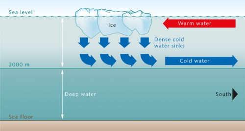
Water plays a central role in the climate system. Its density varies depending on salinity and temperature. Cold, salty water is heavy and sinks to great depths. This causes the circulation of millions of cubic metres of water in the ocean. This powerful phenomenon, which primarily occurs in a few polar regions of the ocean, is called convection. The surface water in the North Atlantic region sinks to a depth of around 2000 metres due to convection. There it settles on an even denser deep-water layer from the Antarctic that extends down to the sea floor. As the cold and salty surface water sinks by convection, salty water flows in from nearby warmer regions, from the direction of the equator. This water is then cooled in the Arctic air and also begins to sink, so that the convection is continuous. Before sinking, the water absorbs enormous amounts of gases such as carbon dioxide at the sea surface, and then transports them rapidly to much greater depths. That is why the highest concentrations of carbon dioxide in the ocean are found in the convection areas. The high carbon dioxide concentrations pumped into the water by convection have been shown to reach depths today of around 3000 metres. Carbon dioxide is transported relatively rapidly by convection to a depth of 2000 metres. In the North Atlantic the transport to greater depths takes significantly longer because carbon dioxide and other gases can only penetrate the deep water by slow mixing processes.
- Low temperature and high salinity are the primary driving forces of convection. They pull the dense water of the polar regions downward, which drives a worldwide convection engine called thermohaline circulation (thermo – driven by temperature differences; haline – driven by salinity differences). The cold, salty water submerges primarily in the Labrador and Greenland Seas, and then flows southward toward the equator and beyond. Although convection only occurs locally in the polar regions, it propels thermohaline circulation, which spans the globe like a giant conveyor belt. Even the Gulf Stream and its branches are driven by convection and thermohaline circulation. Although wind also influences the transport of water masses, its contribution is significantly less.
- 1.6 > The convection process in the North Atlantic: Cold, salty water sinks in the Labrador and in the Greenland Sea. This water forms a layer above the denser deep water from the Antarctic at a depth of around 2000 metres and flows toward the equator. Warmer waters from the upper ocean layers move into the convection area to replace the sinking water.
- But how do the water masses of different densities that drive ocean convection actually originate? Air temperature, evaporation and precipitation are among the most important factors in the answer to this question. The freezing of water in the polar convection regions also plays a central role. Because ice only contains about five tenths of a per cent salt, it leaves behind a considerable amount of salt in the water when it freezes, which increases the salinity of the surrounding ocean water and thus increases its density. The water mass produced by convection in the Arctic is called the North Atlantic Deep Water (NADW).
The global conveyor belt
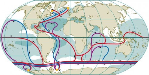
Convection also occurs in the Antarctic regions. Because of their even higher salinity, the water masses produced here sink all the way to the sea floor. This is called the Antarctic Bottom Water (AABW), and it flows across the ocean floor halfway around the globe into the North Atlantic. The AABW is also the deep water layer that the thick intermediate NADW overlies when it sinks by convection. The NADW forms in the Greenland and Labrador Seas. Figure 1.8 schematically illustrates its flow path and the return flow of warm water in the near-surface layers, in the global conveyor belt of thermohaline circulation. The NADW, and especially the AABW, remain in the deep ocean for an amazingly long time. Radioactive carbon-isotope dating of the deep waters indicates that from the time of sinking into the deep until its return to the surface, a period of several hundred or even up to 1000 years will pass.
- 1.8 > The worldwide ocean currents of the thermohaline circulation system are extremely complex. The flow of cold, saline surface water (blue) downward and toward the equator can only be clearly recognized in the Atlantic. Warm surface water (red) flows in the opposite direction, toward the pole. In other areas the current relationships are not as clear-cut as they are in the Gulf Stream system (between North America and Europe). The Circumpolar Current flows around Antarctica, and does so throughout the total depth of the water column. The small yellow circles in the polar regions indicate convection areas. The dark areas are characterized by high salinity and the white areas by low salinity. Salty areas are mostly located in the warm subtropics because of the high evaporation rates here.
- For most of this time the water remains in the colder deep regions of the thermohaline conveyor belt because there the flow rate is slow, at around one to three kilometres per day, due to its high density. The amount of water involved in this cycle is truly immense. Its volume is around 400,000 cubic kilometres, which is equivalent to about one third of the total water in the ocean. This is enough water to fill a swimming pool 400 kilometres long, 100 kilometres wide, and ten kilometres deep. The oceanic conveyor belt transports about 20 million cubic metres of water per second, which is almost 5000 times the amount that flows over Niagara Falls in North America.
Concerns about the breakdown of the Gulf Stream
There has been a great deal of discussion about the extent to which climate change could influence thermohaline circulation and its turnover processes in the Atlantic. After all, convection at high latitudes could be weakened by anthropogenic (caused by humans) warming of the atmosphere and the accompanying decrease in surface-water density. Additionally the density will decrease as a result of lower salinity in the North Atlantic. Climate change will probably cause an increase in freshwater input through a number of pathways, which will affect convection and thermohaline circulation. One way would be by an increase in precipitation over both the continents and the ocean. Another would be the increase of freshwater run-off from the melting glaciers to the sea. Furthermore, because less ice forms when it is warmer, the salt concentration in the surface water would not be increased as much by this process.
- Present-day climate models assume a weakening of the Atlantic turnover process by about 25 per cent by the end of this century. This would mean that less heat is transported northward from the tropics and subtropics. Ice-age scenarios such as those commonly proposed in the literature or films, however, are completely inappropriate, even if the circulation were to completely break down. The decreased influx of heat would be more than compensated by future global warming caused by the enhanced greenhouse effect. The Earth is warming up because of the insulating effect of carbon dioxide in the atmosphere. This temperature increase would offset the decreased northward heat transport from the tropics into the North Atlantic, and even exceed it on the adjacent land masses. When talking about the human impact on climate, scientists therefore tend to refer to a “warm age” rather than an “ice age”.
The Coriolis force The Earth’s rotation causes all free linear motion on the Earth, such as air or water currents, to be diverted to one side. The diverting force is called the Coriolis force or Coriolis acceleration. It works in opposite directions in the northern and southern hemispheres. The Coriolis force is named after the French natural scientist Gaspare Gustave de Coriolis (1792 to 1843), who derived it mathematically.
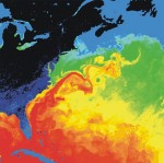
1.9 > Satellite photograph of the Gulf Stream and its eddies. Warm areas are red, cold areas are blue.
Eddies in the ocean – an important climate component
In addition to the large conveyor belt of thermohaline circulation, heat is also transported in the ocean by eddies, which are analogous to low-pressure systems in the atmosphere. But they are significantly smaller than the atmospheric low-pressure systems, which can often be several hundred kilometres wide. These mesoscale eddies form when water flows between regions with large density or temperature differences. They can be clearly recognized on satellite photographs. Investigations have shown that they not only occur at the ocean surface as, for example, in the North Atlantic area, but can also be located at great depths of thousands of metres, e.g. off the coast of Brazil. Because of their strong influence on the large-scale heat transport, these deep-sea eddies also play an important role in long-term climate processes.Variable and dynamic – the influence of wind
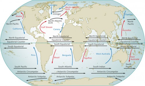
Along with convection, winds also provide an important contribution in driving the ocean currents. In combination with the diverting force caused by the Earth’s rotation (Coriolis force) and the shape of the ocean basins, winds determine the characteristic patterns of the worldwide system of surface currents. Especially striking are the large gyres that extend across entire ocean basins, for example between America and Europe. These surface currents include the Gulf Stream in the Atlantic Ocean, which is driven both by wind and the thermohaline force, as well as the Kuroshio in the Pacific Ocean, whose intensity just decreases with depth. The Gulf Stream is a relatively fast current. Along the coast of North America it reaches a speed of around 3.6 kilometres per hour at the sea surface, which is a casual walking speed. It extends down to a depth of around 2000 metres, where the speed is around ten times slower because the influence of the wind is less and the density of the water is greater. Nevertheless, the wind can in fact have a direct influence down to great depths. Typical wind conditions can change for extended time periods. For example, the normally steady trade winds can blow from a different direction for months at a time, causing changes in the upwelling of water masses, and creating waves and currents in the ocean’s interior that resonate at depth for decades. These waves can also change the ocean temperature and thus also the regional climate. From satellites these waves are perceived as slowly moving ups and downs of the ocean surface.
- Furthermore, in certain regions the prevailing winds cause persistent upwelling and downwelling motion. In some areas the winds drive surface waters away from the land masses, allowing cold water from greater depths to rise in its place. The surface-water temperatures in these areas are therefore especially low. Important upwelling regions are often found on the western margins of continents where the winds blow parallel to the coast (Chile, California, Namibia). In the southern hemisphere, for example, because of the Coriolis force, the water is pushed to the left away from the coast when the wind is blowing from the south. This produces a rolling motion in the water, whereby the water on the surface moves away from the coast and water rises to replace it from below. This upwelling water is usually rich in nutrients, which is why many upwelling regions are also abundant with fish.
- 1.10 > The world’s large ocean currents are also influenced by the prevailing winds. Warm ocean currents are red, and cold currents are shown in blue.
 1.11 > Heat exchange between the atmosphere and the sea surface (in watts per square metre) is very variable depending on the ocean region. Positive values indicate absorption of heat by the ocean, which is characteristic of the tropics, and negative values indicate a heat loss, which is typical for the northern latitudes. In the high arctic regions, however, heat loss is relatively low because the sea ice acts as an insulating layer and prevents heat escaping from the water.
The ocean – a global storehouse for heat
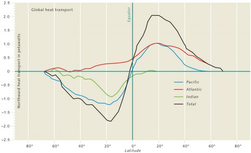
In addition to huge masses of water, large ocean currents also transport enormous amounts of heat around the globe. Similar to the way the water tank in a heating system stores heat from the solar installation on the roof, the oceans are an immense heat reservoir that retains energy from the sun over a long time. The large ocean currents transport this heat for thousands of kilometres and, as illustrated by the example of the Gulf Stream, significantly influence the climate in many regions of the world. In the warm tropics and subtropics up to a latitude of around 30 degrees, more heat arrives at the Earth’s surface on a yearly average than it releases. In the higher latitudes, and extending to the poles, the opposite relationship exists. As a result the atmosphere and the oceans transport energy northward and southward from the equator to compensate for the imbalance. In some tropical regions, such as the eastern Pacific, the ocean gains more than 100 watts of heat per square metre, which is about what a hot-water tank produces to keep an apartment comfortable. In the higher latitudes the ocean releases heat. The areas of greatest heat loss are off the eastern coasts of North America and Asia and in parts of the Arctic, with values of up to 200 watts per square metre. In the North Atlantic and North Pacific regions the oceans release heat on an immense scale. The beneficiaries of this heat are those regions, including Europe, toward which the large current systems transport the warm water. The giant ocean currents transport a maximum amount of heat of just under three petawatts (quadrillion watts) to the north, which is around 600 times that produced by all the power stations worldwide. But the atmosphere also contributes to the energy balance between the tropics and the colder, higher latitudes. It transports an additional 2.5 to three petawatts of heat, resulting in a total northward transport of 5.5 to six petawatts. At European latitudes, heat transport in the atmosphere takes place through propagating low-pressure systems. In the Atlantic Ocean, however, the currents are more controlled and transport heat directly to the north. Here, warm water from the tropics flows northward far into the Arctic Ocean, where the water cools and releases heat into the environment. When it cools, the density increases. It sinks to greater depths and flows southward. The Atlantic current system transports enormous amounts of heat to the north through this thermohaline process and greatly exceeds the share transported by the wind-driven ocean circulation.
- The Atlantic and Pacific Oceans each carry around one petawatt of heat northward from the tropics and subtropics. By comparison, the share moved by the Indian Ocean is negligible. In this system the Atlantic has a unique function among the world’s oceans. It is the only ocean basin that transports heat northward throughout its length, even in the southern hemisphere. Europeans all benefit from the northward trend, thanks to the Gulf Stream and the North Atlantic Current. The climate in the region of the North Atlantic is comparatively mild, especially in northwest Europe, including Germany. The winters in other regions at the same latitude are notably colder. In Canada, for example, the winter temperatures are around ten degrees Celsius lower than in Western Europe. But it is not the ocean circulation alone that causes the mildclimate. Air currents also contribute significantly to this phenomenon. The distribution of mountain ranges, particularly the Rocky Mountains, which run from north to south along the west coast of North America, together with the influence of the Coriolis force, causes the formation of very stable, large-scale vortices in the atmosphere called standing planetary waves. Such a vortex lies above the USA because the Rocky Mountains act as an obstacle to divert large air masses. As a consequence the winds are predominantly westerly over the Atlantic carrying relatively mild air to northwest Europe, and fend off the cold from the east.
- 1.12 > Oceans contribute to the global transport of heat with different intensities. In the southern hemisphere, only the Atlantic transports heat to the north (positive values). The equator lies at zero degrees. The Atlantic and Pacific each carry around one petawatt of heat as far as 20 degrees north latitude. Further to the north, the Atlantic carries more than the Pacific. The Indian Ocean, on the other hand, makes a negligible contribution to northward heat transport.
![Fig. 1.13: © [M], Bryan & Cherry Alexander/Arcticphoto/laif 1.13 > As a rule, icebergs consist of freshwater or contain only small amounts of salt. Because of their slightly lower density compared to seawater, a small fraction extends above the water. The largest part is below the surface. © [M], Bryan & Cherry Alexander/Arcticphoto/laif](https://worldoceanreview.com/wp-content/uploads/2010/10/kapitel_01b-150x166.jpg) 1.13 > As a rule, icebergs consist of freshwater or contain only small amounts of salt. Because of their slightly lower density compared to seawater, a small fraction extends above the water. The largest part is below the surface.
1.13 > As a rule, icebergs consist of freshwater or contain only small amounts of salt. Because of their slightly lower density compared to seawater, a small fraction extends above the water. The largest part is below the surface.The uncertain future of sea ice
Sea ice in the Arctic regions has a significant impact on heat exchange between the atmosphere and ocean, because it acts as an insulating layer to prevent heat from escaping from the water. Considering how large the area of ice is, it is clear that it must have an impact on the global climate. In the Arctic Ocean the sea ice, which is commonly called pack ice, has an average thickness of three metres. In the Southern Ocean it averages around one metre. The total area of sea ice expands and recedes with the seasons. On a yearly average around seven per cent of the oceans (about 23 million square kilometres) is covered with ice, which is equal to about three times the size of Australia. By comparison, the ice masses on land are relatively stable. They permanently cover around ten per cent of the land surface (14.8 million square kilometres). Scientists call the ice-covered areas of the Earth the cryosphere. In addition to land and sea ice, this also includes the shelf ice, the parts of continental ice sheets that extend into the ocean. Changes in the sea ice, including its extent, areal coverage, thickness, and movement, are caused by dynamic processes such as ocean currents and by thermodynamic processes such as freezing and melting. These, in turn, are influenced by solar radiation as well as the heat flux at the sea surface. One of the most conspicuous and important characteristics of climate fluctuations is the change in sea-ice extent in the polar regions. During some winters the Arctic sea ice extends much further to the south than in others. Geophysicists consider the sea ice to be simply a thin, discontinuous layer on the polar oceans that is driven by winds and ocean currents, and is variable in thickness and extent. Sea ice forms a boundary between the two large components of the Earth system, the atmosphere and the ocean, and very significantly influences their interaction. Sea ice has a strong reflective property, called albedo, and it reflects a considerable amount of the incoming sunlight. This effect is enhanced when the ice is covered with snow. The sea ice therefore influences the radiation balance of the Earth and thus plays an important role in the climate system.
- The impact of sea ice on climate is further amplified by its insulating effect between the atmosphere and ocean. It inhibits the exchange of heat and wind energy between the atmosphere and ocean considerably. The atmosphere is therefore much colder above the sea-ice surface than above the open ocean. This has the effect of increasing the air-temperature difference between the tropics, subtropics, and the polar regions. In warmer regions the air has a greater tendency to rise, which lowers the air pressure significantly. By contrast, in very cold regions the air is heavier, and high pressure zones are created. Accordingly, the compensating air flow between high and low pressure areas is strong and, in concert with the Coriolis force, creates stronger westly winds in the middle latitudes. Of course, sea ice also influences convection processes in the ocean, and thus the formation of deep and bottom water. Sea ice therefore plays an important role in the large-scale ocean circulation, especially with regard to thermohaline circulation. It is not yet known how global warming affects the formation of sea ice and the related processes. Ice melts when it becomes warmer. But it is difficult to predict what effect this has on the currents. In any case, all climate models predict an acceleration of warming in the Arctic with a continuing rise in trace-gas concentrations.
- In addition, observations indicate a clear decrease in Arctic sea-ice cover in recent decades. This is partly related to a positive feedback mechanism called the ice-albedo feedback. Light surfaces have a very high albedo. When the sea ice retreats as a result of global warming, albedo decreases and more solar energy is available, which leads to additional warming, and melts more ice. This process primarily occurs at the margins of the sea ice. Similar to a spot of grass on the edge of a patchy snow cover, the seawater at the margins of the ice warms more rapidly, and the ice thaws faster there. The further the ice retreats, the larger the area of the open, relatively dark sea surface becomes. The melting is thus amplified. The shrinking of sea ice could therefore amplify climate change in the future. Ironically, this would provide people with something that they have been wanting for a long time: the opening of a northern seaway from Europe across the Arctic to Asia – the Northern Sea Route. In recent years the ice has retreated at such a rate that Arctic waters along the north coast of Russia could be navigable year-round by commercial ships in the future. The route is several thousand kilometres shorter than the trip through the Suez Canal. In the early autumn of 2009 a Bremen shipping company became one of the first private companies in the world to navigate the Northern Sea Route with a merchant vessel. But the negative consequences of climate change will presumably outweigh the advantages of a navigable northern route. There is, for instance, a substantial negative impact on Arctic animals such as the polar bear, whose habitat is melting away.
- The large ocean currents and their driving forces have already been intensively investigated, but there are still many unanswered questions in the fine details. For example, thermohaline circulation, with the interplay of its driving factors, has not yet been completely explained. Different mathematical models have produced different conclusions. All models use the same equations, variables, and input parameters. But it is difficult to accurately estimate climate influences at scales of a few kilometers or even smaller and to apply them correctly within the large, global models.
